![](/images/other/stat-length.png)
![Tour Wandern Morancé - A_MORANCÉ 69480 Isérable - Culattes - Photo](https://media.geolcdn.com/t/1900/400/ext.pjpeg?maxdim=2&url=https%3A%2F%2Fstatic1.geolcdn.com%2Fsiteimages%2Fupload%2Ffiles%2F1553511878bg_sport_marche.png)
A_MORANCÉ 69480 Isérable - Culattes
ANDREJAC
Benutzer
![Länge](/images/other/stat-length.png)
Länge
10,5 km
![Maximale Höhe](https://static1.geolcdn.com/siteimages/upload/files/1508320355ic_sort_altitude_max_24dp.png)
Maximale Höhe
273 m
![Positive Höhendifferenz](https://static1.geolcdn.com/siteimages/upload/files/1508320355ic_sort_den_pos_24dp.png)
Positive Höhendifferenz
121 m
![Km-Effort](/images/other/stat-length.png)
Km-Effort
12,1 km
![Min. Höhe](https://static1.geolcdn.com/siteimages/upload/files/1508320355ic_sort_altitude_min_24dp.png)
Min. Höhe
176 m
![Negative Höhendifferenz](https://static1.geolcdn.com/siteimages/upload/files/1508320355ic_sort_den_neg_24dp.png)
Negative Höhendifferenz
121 m
![Boucle](https://static1.geolcdn.com/siteimages/upload/files/16400158638029165_repeat_loop_refresh_sync_direction_icon.png)
Boucle
Ja
Erstellungsdatum :
2017-02-14 00:00:00.0
Letzte Änderung :
2017-02-14 00:00:00.0
![Wandern](https://static1.geolcdn.com/sitytour/trail-icons/101.png)
2h40
Schwierigkeit : Einfach
![Scannen Sie diesen QR-Code, um die Tour in der SityTrail-Anwendung zu öffnen](https://capi.geolives.com/qq0zvz2zws4bq2lad0pu/sitytour/trails/694775/qr.png?size=200)
Kostenlosegpshiking-Anwendung
Über SityTrail
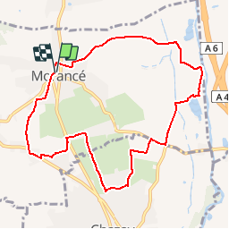
Tour Wandern von 10,5 km verfügbar auf Auvergne-Rhone-Alpen, Rhône, Morancé. Diese Tour wird von ANDREJAC vorgeschlagen.
Beschreibung
Départ et retour : Eglise de Morancé.
Rue de l'Eglise, rue du Coteau,ch de la Poyat, ch des lacs, st épuration, le Bief, les Grandes Culattes, bois Micollier, Trédo, ch de la Combe, rue de la Libération.
Ort
Land:
France
Region :
Auvergne-Rhone-Alpen
Abteilung/Provinz :
Rhône
Kommune :
Morancé
Standort:
Unknown
Gehen Sie:(Dec)
Gehen Sie:(UTM)
631884 ; 5084127 (31T) N.
Kommentare
Touren in der Umgebung
![Tour Mountainbike Lozanne - La 5ème Vélozannaise (2014-VTT-45km) - Lozanne - Photo](https://media.geolcdn.com/t/375/260/ext.jpg?maxdim=2&url=https%3A%2F%2Fservices.sitytrail.com%2FGeolivesWS%2FDownloadMedia.ashx%3FTrailID%3D318042%26Media%3D17513_6.jpg)
![Mountainbike Mountainbike](https://static1.geolcdn.com/sitytour/trail-icons/202.png)
La 5ème Vélozannaise (2014-VTT-45km) - Lozanne
Mountainbike
Schwierig
(1)
Lozanne,
Auvergne-Rhone-Alpen,
Rhône,
France
![](/images/other/stat-length.png)
45 km | 59 km-effort
3h 45min
![](https://static1.geolcdn.com/siteimages/upload/files/16400158638029165_repeat_loop_refresh_sync_direction_icon.png)
Ja
![Tour Reiten Chasselay - chasselay florian alain - Photo](https://media.geolcdn.com/t/375/260/ext.jpg?maxdim=2&url=https%3A%2F%2Fstatic1.geolcdn.com%2Fsiteimages%2Fupload%2Ffiles%2F1524743154cheval.jpg)
![Reiten Reiten](https://static1.geolcdn.com/sitytour/trail-icons/301.png)
chasselay florian alain
Reiten
Einfach
(1)
Chasselay,
Auvergne-Rhone-Alpen,
Rhône,
France
![](/images/other/stat-length.png)
13,3 km | 17,3 km-effort
2h 16min
![](https://static1.geolcdn.com/siteimages/upload/files/16400158638029165_repeat_loop_refresh_sync_direction_icon.png)
Ja
![Tour Zu Fuß Saint-Jean-des-Vignes - De Bagnols à Lozanne - Photo](https://media.geolcdn.com/t/375/260/0483cf43-fc67-45ae-bc2f-363ddcb48e98.jpeg&format=jpg&maxdim=2)
![Zu Fuß Zu Fuß](https://static1.geolcdn.com/sitytour/trail-icons/100.png)
De Bagnols à Lozanne
Zu Fuß
Einfach
Saint-Jean-des-Vignes,
Auvergne-Rhone-Alpen,
Rhône,
France
![](/images/other/stat-length.png)
4 km | 5 km-effort
1h 7min
![](https://static1.geolcdn.com/siteimages/upload/files/16400158638029165_repeat_loop_refresh_sync_direction_icon.png)
Nein
![Tour Zu Fuß Lozanne - De Lozanne à Marcy - Photo](https://media.geolcdn.com/t/375/260/08fe2957-d9d7-452a-b8d4-1f5434bd4ed8.jpeg&format=jpg&maxdim=2)
![Zu Fuß Zu Fuß](https://static1.geolcdn.com/sitytour/trail-icons/100.png)
De Lozanne à Marcy
Zu Fuß
Einfach
Lozanne,
Auvergne-Rhone-Alpen,
Rhône,
France
![](/images/other/stat-length.png)
12,2 km | 15,6 km-effort
3h 32min
![](https://static1.geolcdn.com/siteimages/upload/files/16400158638029165_repeat_loop_refresh_sync_direction_icon.png)
Nein
![Tour Wandern Saint-Jean-des-Vignes - A_ST JEAN DES VIGNES 69380 Pierre Folle - Fontainebleau - Photo](https://media.geolcdn.com/t/375/260/ext.jpg?maxdim=2&url=https%3A%2F%2Fstatic1.geolcdn.com%2Fsiteimages%2Fupload%2Ffiles%2F1553511878bg_sport_marche.png)
![Wandern Wandern](https://static1.geolcdn.com/sitytour/trail-icons/101.png)
A_ST JEAN DES VIGNES 69380 Pierre Folle - Fontainebleau
Wandern
Einfach
(1)
Saint-Jean-des-Vignes,
Auvergne-Rhone-Alpen,
Rhône,
France
![](/images/other/stat-length.png)
8 km | 11 km-effort
3h 0min
![](https://static1.geolcdn.com/siteimages/upload/files/16400158638029165_repeat_loop_refresh_sync_direction_icon.png)
Ja
![Tour Wandern Morancé - morance - Photo](https://media.geolcdn.com/t/375/260/ext.jpg?maxdim=2&url=https%3A%2F%2Fstatic1.geolcdn.com%2Fsiteimages%2Fupload%2Ffiles%2F1553511878bg_sport_marche.png)
![Wandern Wandern](https://static1.geolcdn.com/sitytour/trail-icons/101.png)
morance
Wandern
Sehr leicht
(1)
Morancé,
Auvergne-Rhone-Alpen,
Rhône,
France
![](/images/other/stat-length.png)
7,9 km | 9,7 km-effort
1h 46min
![](https://static1.geolcdn.com/siteimages/upload/files/16400158638029165_repeat_loop_refresh_sync_direction_icon.png)
Ja
![Tour Reiten Les Chères - 5 nov formation - Photo](https://media.geolcdn.com/t/375/260/ext.jpg?maxdim=2&url=https%3A%2F%2Fstatic1.geolcdn.com%2Fsiteimages%2Fupload%2Ffiles%2F1524743154cheval.jpg)
![Reiten Reiten](https://static1.geolcdn.com/sitytour/trail-icons/301.png)
5 nov formation
Reiten
Einfach
(2)
Les Chères,
Auvergne-Rhone-Alpen,
Rhône,
France
![](/images/other/stat-length.png)
13,6 km | 15 km-effort
1h 58min
![](https://static1.geolcdn.com/siteimages/upload/files/16400158638029165_repeat_loop_refresh_sync_direction_icon.png)
Ja
![Tour Wandern Charnay - Charnay/Châtillon/Chessy (12 km - D. 330 m) - Photo](https://media.geolcdn.com/t/375/260/1a2d3b7e-3e2e-464b-b810-b35fd7c37452.jpeg&format=jpg&maxdim=2)
![Wandern Wandern](https://static1.geolcdn.com/sitytour/trail-icons/101.png)
Charnay/Châtillon/Chessy (12 km - D. 330 m)
Wandern
Einfach
Charnay,
Auvergne-Rhone-Alpen,
Rhône,
France
![](/images/other/stat-length.png)
12,5 km | 16,9 km-effort
3h 7min
![](https://static1.geolcdn.com/siteimages/upload/files/16400158638029165_repeat_loop_refresh_sync_direction_icon.png)
Ja
![Tour Zu Fuß Chazay-d'Azergues - Tour des Pierres Dorées en Beaujolais - Photo](https://media.geolcdn.com/t/375/260/85e178bb-7e2d-451d-ad36-673bc672e36a.jpeg&format=jpg&maxdim=2)
![Zu Fuß Zu Fuß](https://static1.geolcdn.com/sitytour/trail-icons/100.png)
Tour des Pierres Dorées en Beaujolais
Zu Fuß
Einfach
Chazay-d'Azergues,
Auvergne-Rhone-Alpen,
Rhône,
France
![](/images/other/stat-length.png)
7,6 km | 10,2 km-effort
2h 19min
![](https://static1.geolcdn.com/siteimages/upload/files/16400158638029165_repeat_loop_refresh_sync_direction_icon.png)
Nein