![](/images/other/stat-length.png)
![Tour Wandern Aspres-sur-Buëch - Circuit de la Digue. - Photo](https://media.geolcdn.com/t/1900/400/ext.pjpeg?maxdim=2&url=https%3A%2F%2Fservices.sitytrail.com%2FGeolivesWS%2FDownloadMedia.ashx%3FTrailID%3D694564%26Media%3Dfix__20170207131547.jpg)
Circuit de la Digue.
Dervalmarc
Benutzer
![Länge](/images/other/stat-length.png)
Länge
6,1 km
![Maximale Höhe](https://static1.geolcdn.com/siteimages/upload/files/1508320355ic_sort_altitude_max_24dp.png)
Maximale Höhe
893 m
![Positive Höhendifferenz](https://static1.geolcdn.com/siteimages/upload/files/1508320355ic_sort_den_pos_24dp.png)
Positive Höhendifferenz
155 m
![Km-Effort](/images/other/stat-length.png)
Km-Effort
8,1 km
![Min. Höhe](https://static1.geolcdn.com/siteimages/upload/files/1508320355ic_sort_altitude_min_24dp.png)
Min. Höhe
754 m
![Negative Höhendifferenz](https://static1.geolcdn.com/siteimages/upload/files/1508320355ic_sort_den_neg_24dp.png)
Negative Höhendifferenz
150 m
![Boucle](https://static1.geolcdn.com/siteimages/upload/files/16400158638029165_repeat_loop_refresh_sync_direction_icon.png)
Boucle
Ja
Erstellungsdatum :
2017-02-07 00:00:00.0
Letzte Änderung :
2017-02-07 00:00:00.0
![Wandern](https://static1.geolcdn.com/sitytour/trail-icons/101.png)
1h02
Schwierigkeit : Einfach
![Scannen Sie diesen QR-Code, um die Tour in der SityTrail-Anwendung zu öffnen](https://capi.geolives.com/qq0zvz2zws4bq2lad0pu/sitytour/trails/694564/qr.png?size=200)
Kostenlosegpshiking-Anwendung
Über SityTrail
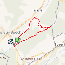
Tour Wandern von 6,1 km verfügbar auf Provence-Alpes-Côte d'Azur, Hochalpen, Aspres-sur-Buëch. Diese Tour wird von Dervalmarc vorgeschlagen.
Beschreibung
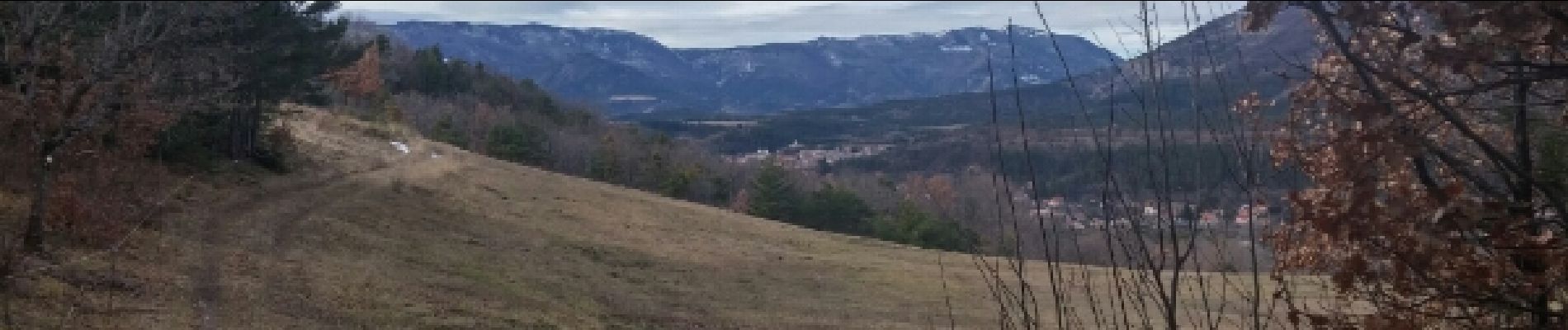
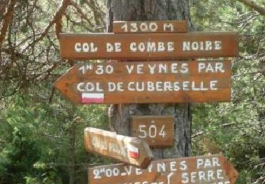
Randonnée très varié.Première partie au bord du Buech,seconde partie dans une forêt mixte de feuillus et de pins.
Ort
Land:
France
Region :
Provence-Alpes-Côte d'Azur
Abteilung/Provinz :
Hochalpen
Kommune :
Aspres-sur-Buëch
Standort:
Unknown
Gehen Sie:(Dec)
Gehen Sie:(UTM)
719036 ; 4932811 (31T) N.
Kommentare
Touren in der Umgebung
![Tour Mountainbike Veynes - VTT29 - Rando famille - Photo](https://media.geolcdn.com/t/375/260/ext.jpg?maxdim=2&url=https%3A%2F%2Fservices.sitytrail.com%2FGeolivesWS%2FDownloadMedia.ashx%3FTrailID%3D894049%26Media%3D41fd01b2-a1b9-4de0-b05b-7c7f08af0a98.jpg)
![Mountainbike Mountainbike](https://static1.geolcdn.com/sitytour/trail-icons/202.png)
VTT29 - Rando famille
Mountainbike
Einfach
(1)
Veynes,
Provence-Alpes-Côte d'Azur,
Hochalpen,
France
![](/images/other/stat-length.png)
10,9 km | 13,6 km-effort
54min
![](https://static1.geolcdn.com/siteimages/upload/files/16400158638029165_repeat_loop_refresh_sync_direction_icon.png)
Ja
![Tour Mountainbike Veynes - VTT14 - Les crêtes de la Longeagne - Photo](https://media.geolcdn.com/t/375/260/ext.jpg?maxdim=2&url=https%3A%2F%2Fservices.sitytrail.com%2FGeolivesWS%2FDownloadMedia.ashx%3FTrailID%3D893997%26Media%3D7ccf264f-f2dd-40d2-9710-b4f1366285f7.jpg)
![Mountainbike Mountainbike](https://static1.geolcdn.com/sitytour/trail-icons/202.png)
VTT14 - Les crêtes de la Longeagne
Mountainbike
Sehr schwierig
(1)
Veynes,
Provence-Alpes-Côte d'Azur,
Hochalpen,
France
![](/images/other/stat-length.png)
39 km | 57 km-effort
3h 15min
![](https://static1.geolcdn.com/siteimages/upload/files/16400158638029165_repeat_loop_refresh_sync_direction_icon.png)
Ja
![Tour Mountainbike Veynes - VTT03 - Tous les Eygaux - Photo](https://media.geolcdn.com/t/375/260/ext.jpg?maxdim=2&url=https%3A%2F%2Fservices.sitytrail.com%2FGeolivesWS%2FDownloadMedia.ashx%3FTrailID%3D893894%26Media%3Dff964c78-0895-4177-a23a-bbf5c1f8ef2b.jpg)
![Mountainbike Mountainbike](https://static1.geolcdn.com/sitytour/trail-icons/202.png)
VTT03 - Tous les Eygaux
Mountainbike
Medium
(2)
Veynes,
Provence-Alpes-Côte d'Azur,
Hochalpen,
France
![](/images/other/stat-length.png)
23 km | 31 km-effort
1h 31min
![](https://static1.geolcdn.com/siteimages/upload/files/16400158638029165_repeat_loop_refresh_sync_direction_icon.png)
Ja
![Tour Mountainbike Veynes - VTT02 - Aiguebelle - Photo](https://media.geolcdn.com/t/375/260/ext.jpg?maxdim=2&url=https%3A%2F%2Fservices.sitytrail.com%2FGeolivesWS%2FDownloadMedia.ashx%3FTrailID%3D893892%26Media%3Da8e741f3-b85e-4e92-89bd-a0f44b11f95d.jpg)
![Mountainbike Mountainbike](https://static1.geolcdn.com/sitytour/trail-icons/202.png)
VTT02 - Aiguebelle
Mountainbike
Einfach
(2)
Veynes,
Provence-Alpes-Côte d'Azur,
Hochalpen,
France
![](/images/other/stat-length.png)
16,7 km | 21 km-effort
1h 23min
![](https://static1.geolcdn.com/siteimages/upload/files/16400158638029165_repeat_loop_refresh_sync_direction_icon.png)
Ja
![Tour Mountainbike Veynes - VTT01 - Les Eygaux - Photo](https://media.geolcdn.com/t/375/260/ext.jpg?maxdim=2&url=https%3A%2F%2Fservices.sitytrail.com%2FGeolivesWS%2FDownloadMedia.ashx%3FTrailID%3D893891%26Media%3Da3cfe01b-296c-449d-80b6-97a4ee7d4f1d.jpg)
![Mountainbike Mountainbike](https://static1.geolcdn.com/sitytour/trail-icons/202.png)
VTT01 - Les Eygaux
Mountainbike
Einfach
(3)
Veynes,
Provence-Alpes-Côte d'Azur,
Hochalpen,
France
![](/images/other/stat-length.png)
14,1 km | 19,2 km-effort
1h 13min
![](https://static1.geolcdn.com/siteimages/upload/files/16400158638029165_repeat_loop_refresh_sync_direction_icon.png)
Ja
![Tour Wandern Veynes - R10 Le tour des Eygaux - Photo](https://media.geolcdn.com/t/375/260/ext.jpg?maxdim=2&url=https%3A%2F%2Fservices.sitytrail.com%2FGeolivesWS%2FDownloadMedia.ashx%3FTrailID%3D890865%26Media%3D045a0fa6-2484-4383-b3d3-624322b8ead1.jpg)
![Wandern Wandern](https://static1.geolcdn.com/sitytour/trail-icons/101.png)
R10 Le tour des Eygaux
Wandern
Sehr leicht
(4)
Veynes,
Provence-Alpes-Côte d'Azur,
Hochalpen,
France
![](/images/other/stat-length.png)
7,8 km | 11,3 km-effort
2h 24min
![](https://static1.geolcdn.com/siteimages/upload/files/16400158638029165_repeat_loop_refresh_sync_direction_icon.png)
Ja
![Tour Wandern Veynes - R09 Le tour de Veynes - Photo](https://media.geolcdn.com/t/375/260/ext.jpg?maxdim=2&url=https%3A%2F%2Fservices.sitytrail.com%2FGeolivesWS%2FDownloadMedia.ashx%3FTrailID%3D890863%26Media%3Ddcd71a68-090d-41eb-95df-d7f5c76863f4.jpg)
![Wandern Wandern](https://static1.geolcdn.com/sitytour/trail-icons/101.png)
R09 Le tour de Veynes
Wandern
Sehr leicht
(3)
Veynes,
Provence-Alpes-Côte d'Azur,
Hochalpen,
France
![](/images/other/stat-length.png)
9,5 km | 12,3 km-effort
2h 40min
![](https://static1.geolcdn.com/siteimages/upload/files/16400158638029165_repeat_loop_refresh_sync_direction_icon.png)
Ja
![Tour Wandern Veynes - R52 Le col de Cuberselle - Photo](https://media.geolcdn.com/t/375/260/ext.jpg?maxdim=2&url=https%3A%2F%2Fservices.sitytrail.com%2FGeolivesWS%2FDownloadMedia.ashx%3FTrailID%3D890856%26Media%3D09e22e66-6969-4dad-8e24-d5d048fec167.jpg)
![Wandern Wandern](https://static1.geolcdn.com/sitytour/trail-icons/101.png)
R52 Le col de Cuberselle
Wandern
Medium
(3)
Veynes,
Provence-Alpes-Côte d'Azur,
Hochalpen,
France
![](/images/other/stat-length.png)
10,8 km | 17,2 km-effort
3h 31min
![](https://static1.geolcdn.com/siteimages/upload/files/16400158638029165_repeat_loop_refresh_sync_direction_icon.png)
Ja
![Tour Laufen Veynes - Trail 05 - Le Défi des Argouses - Photo](https://media.geolcdn.com/t/375/260/ext.jpg?maxdim=2&url=https%3A%2F%2Fservices.sitytrail.com%2FGeolivesWS%2FDownloadMedia.ashx%3FTrailID%3D839610%26Media%3Dfix__20171003172659.jpg)
![Laufen Laufen](https://static1.geolcdn.com/sitytour/trail-icons/103.png)
Trail 05 - Le Défi des Argouses
Laufen
Schwierig
(3)
Veynes,
Provence-Alpes-Côte d'Azur,
Hochalpen,
France
![](/images/other/stat-length.png)
9 km | 11,9 km-effort
48min
![](https://static1.geolcdn.com/siteimages/upload/files/16400158638029165_repeat_loop_refresh_sync_direction_icon.png)
Ja