![](/images/other/stat-length.png)
![Tour Wandern Ceaulmont - Le circuit du Val de Creuse - Photo](https://media.geolcdn.com/t/1900/400/ext.pjpeg?maxdim=2&url=https%3A%2F%2Fstatic1.geolcdn.com%2Fsiteimages%2Fupload%2Ffiles%2F1553511878bg_sport_marche.png)
Le circuit du Val de Creuse
Phil36
Benutzer
![Länge](/images/other/stat-length.png)
Länge
15,1 km
![Maximale Höhe](https://static1.geolcdn.com/siteimages/upload/files/1508320355ic_sort_altitude_max_24dp.png)
Maximale Höhe
248 m
![Positive Höhendifferenz](https://static1.geolcdn.com/siteimages/upload/files/1508320355ic_sort_den_pos_24dp.png)
Positive Höhendifferenz
215 m
![Km-Effort](/images/other/stat-length.png)
Km-Effort
18 km
![Min. Höhe](https://static1.geolcdn.com/siteimages/upload/files/1508320355ic_sort_altitude_min_24dp.png)
Min. Höhe
121 m
![Negative Höhendifferenz](https://static1.geolcdn.com/siteimages/upload/files/1508320355ic_sort_den_neg_24dp.png)
Negative Höhendifferenz
215 m
![Boucle](https://static1.geolcdn.com/siteimages/upload/files/16400158638029165_repeat_loop_refresh_sync_direction_icon.png)
Boucle
Ja
Erstellungsdatum :
2017-03-23 00:00:00.0
Letzte Änderung :
2017-03-23 00:00:00.0
![Wandern](https://static1.geolcdn.com/sitytour/trail-icons/101.png)
3h55
Schwierigkeit : Medium
![Scannen Sie diesen QR-Code, um die Tour in der SityTrail-Anwendung zu öffnen](https://capi.geolives.com/qq0zvz2zws4bq2lad0pu/sitytour/trails/684883/qr.png?size=200)
Kostenlosegpshiking-Anwendung
Über SityTrail
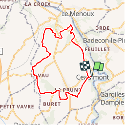
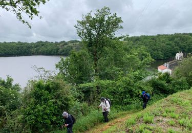
Tour Wandern von 15,1 km verfügbar auf Zentrum-Loiretal, Indre, Ceaulmont. Diese Tour wird von Phil36 vorgeschlagen.
Beschreibung
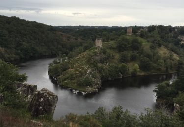
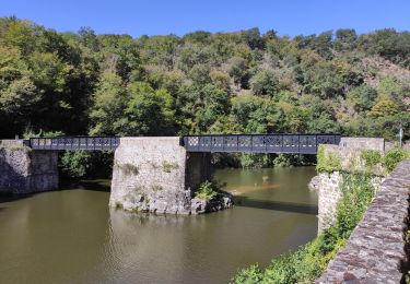
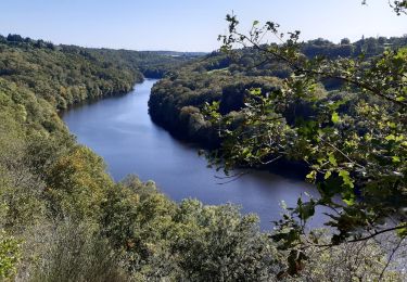
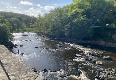
Riveraine de la Creuse sur une quinzaine de kilomètres entre le pont Noir et le Vivier, la commune de Ceaulmont compte de nombreux moulins hérités de l'exploitation de l'énergie hydroulique.
Ort
Land:
France
Region :
Zentrum-Loiretal
Abteilung/Provinz :
Indre
Kommune :
Ceaulmont
Standort:
Unknown
Gehen Sie:(Dec)
Gehen Sie:(UTM)
391036 ; 5153172 (31T) N.
Kommentare
Touren in der Umgebung
![Tour Wandern Gargilesse-Dampierre - SityTrail - La Chaumerette,Gargilesse - Photo](https://media.geolcdn.com/t/375/260/ext.jpg?maxdim=2&url=https%3A%2F%2Fstatic1.geolcdn.com%2Fsiteimages%2Fupload%2Ffiles%2F1553511878bg_sport_marche.png)
![Wandern Wandern](https://static1.geolcdn.com/sitytour/trail-icons/101.png)
SityTrail - La Chaumerette,Gargilesse
Wandern
Sehr schwierig
(1)
Gargilesse-Dampierre,
Zentrum-Loiretal,
Indre,
France
![](/images/other/stat-length.png)
15,8 km | 19,7 km-effort
4h 28min
![](https://static1.geolcdn.com/siteimages/upload/files/16400158638029165_repeat_loop_refresh_sync_direction_icon.png)
Ja
![Tour Zu Fuß Gargilesse-Dampierre - La Gargilesse secrète et sauvage - Photo](https://media.geolcdn.com/t/375/260/f45fabfe-9f8e-4791-bb71-f646d5039a7b.jpeg&format=jpg&maxdim=2)
![Zu Fuß Zu Fuß](https://static1.geolcdn.com/sitytour/trail-icons/100.png)
La Gargilesse secrète et sauvage
Zu Fuß
Einfach
Gargilesse-Dampierre,
Zentrum-Loiretal,
Indre,
France
![](/images/other/stat-length.png)
6,7 km | 8,3 km-effort
1h 53min
![](https://static1.geolcdn.com/siteimages/upload/files/16400158638029165_repeat_loop_refresh_sync_direction_icon.png)
Nein
![Tour Wandern Gargilesse-Dampierre - Compostelle etape 13 - Photo](https://media.geolcdn.com/t/375/260/392da69d-726a-4863-8547-359569904a75.jpg&format=jpg&maxdim=2)
![Wandern Wandern](https://static1.geolcdn.com/sitytour/trail-icons/101.png)
Compostelle etape 13
Wandern
Schwierig
Gargilesse-Dampierre,
Zentrum-Loiretal,
Indre,
France
![](/images/other/stat-length.png)
29 km | 39 km-effort
9h 58min
![](https://static1.geolcdn.com/siteimages/upload/files/16400158638029165_repeat_loop_refresh_sync_direction_icon.png)
Nein
![Tour Wandern Gargilesse-Dampierre - Beau parcours au départ du moulin de Gargilesse - Photo](https://media.geolcdn.com/t/375/260/fa1c368f-74d0-46db-8d60-0af1fbae6602.jpg&format=jpg&maxdim=2)
![Wandern Wandern](https://static1.geolcdn.com/sitytour/trail-icons/101.png)
Beau parcours au départ du moulin de Gargilesse
Wandern
Sehr leicht
Gargilesse-Dampierre,
Zentrum-Loiretal,
Indre,
France
![](/images/other/stat-length.png)
16,2 km | 21 km-effort
3h 48min
![](https://static1.geolcdn.com/siteimages/upload/files/16400158638029165_repeat_loop_refresh_sync_direction_icon.png)
Ja
![Tour Mountainbike Le Menoux - Vallée de la Creuse 1 - Photo](https://media.geolcdn.com/t/375/260/ext.jpg?maxdim=2&url=https%3A%2F%2Fstatic1.geolcdn.com%2Fsiteimages%2Fupload%2Ffiles%2F1524743154velo.jpg)
![Mountainbike Mountainbike](https://static1.geolcdn.com/sitytour/trail-icons/202.png)
Vallée de la Creuse 1
Mountainbike
Medium
(1)
Le Menoux,
Zentrum-Loiretal,
Indre,
France
![](/images/other/stat-length.png)
51 km | 63 km-effort
Unbekannt
![](https://static1.geolcdn.com/siteimages/upload/files/16400158638029165_repeat_loop_refresh_sync_direction_icon.png)
Nein
![Tour Wandern Gargilesse-Dampierre - La chaumerette pont des piles - Photo](https://media.geolcdn.com/t/375/260/c178561a-edbd-4064-b2a7-0ed1ebb39ac8.jpg&format=jpg&maxdim=2)
![Wandern Wandern](https://static1.geolcdn.com/sitytour/trail-icons/101.png)
La chaumerette pont des piles
Wandern
Schwierig
Gargilesse-Dampierre,
Zentrum-Loiretal,
Indre,
France
![](/images/other/stat-length.png)
22 km | 27 km-effort
5h 28min
![](https://static1.geolcdn.com/siteimages/upload/files/16400158638029165_repeat_loop_refresh_sync_direction_icon.png)
Ja
![Tour sport Le Menoux - Sob 17 le menoux cuzion - Photo](https://media.geolcdn.com/t/375/260/a7ea09a4-f376-4dab-a4f6-85126f46f916.jpg&format=jpg&maxdim=2)
Sob 17 le menoux cuzion
sport
Sehr leicht
Le Menoux,
Zentrum-Loiretal,
Indre,
France
![](/images/other/stat-length.png)
16,6 km | 21 km-effort
Unbekannt
![](https://static1.geolcdn.com/siteimages/upload/files/16400158638029165_repeat_loop_refresh_sync_direction_icon.png)
Nein
![Tour Wandern Cuzion - Cuzion - Photo](https://media.geolcdn.com/t/375/260/b03cf623-7ff8-4acd-94ea-f6c2044c2cbd.jpg&format=jpg&maxdim=2)
![Wandern Wandern](https://static1.geolcdn.com/sitytour/trail-icons/101.png)
Cuzion
Wandern
Schwierig
Cuzion,
Zentrum-Loiretal,
Indre,
France
![](/images/other/stat-length.png)
13,6 km | 17,2 km-effort
3h 24min
![](https://static1.geolcdn.com/siteimages/upload/files/16400158638029165_repeat_loop_refresh_sync_direction_icon.png)
Ja
![Tour Wandern Gargilesse-Dampierre - 1 er rando - Photo](https://media.geolcdn.com/t/375/260/ext.jpg?maxdim=2&url=https%3A%2F%2Fstatic1.geolcdn.com%2Fsiteimages%2Fupload%2Ffiles%2F1553511878bg_sport_marche.png)
![Wandern Wandern](https://static1.geolcdn.com/sitytour/trail-icons/101.png)
1 er rando
Wandern
Sehr schwierig
Gargilesse-Dampierre,
Zentrum-Loiretal,
Indre,
France
![](/images/other/stat-length.png)
16,9 km | 20 km-effort
3h 58min
![](https://static1.geolcdn.com/siteimages/upload/files/16400158638029165_repeat_loop_refresh_sync_direction_icon.png)
Ja