![](/images/other/stat-length.png)
![Tour Wandern Miribel-Lanchâtre - Les crêtes de la Ferrière - Photo](https://media.geolcdn.com/t/1900/400/ext.pjpeg?maxdim=2&url=https%3A%2F%2Fservices.sitytrail.com%2FGeolivesWS%2FDownloadMedia.ashx%3FTrailID%3D683639%26Media%3Dfix__20170112133023.jpg)
Les crêtes de la Ferrière
patjobou
Benutzer
![Länge](/images/other/stat-length.png)
![Maximale Höhe](https://static1.geolcdn.com/siteimages/upload/files/1508320355ic_sort_altitude_max_24dp.png)
![Positive Höhendifferenz](https://static1.geolcdn.com/siteimages/upload/files/1508320355ic_sort_den_pos_24dp.png)
![Km-Effort](/images/other/stat-length.png)
![Min. Höhe](https://static1.geolcdn.com/siteimages/upload/files/1508320355ic_sort_altitude_min_24dp.png)
![Negative Höhendifferenz](https://static1.geolcdn.com/siteimages/upload/files/1508320355ic_sort_den_neg_24dp.png)
![Boucle](https://static1.geolcdn.com/siteimages/upload/files/16400158638029165_repeat_loop_refresh_sync_direction_icon.png)
![Wandern](https://static1.geolcdn.com/sitytour/trail-icons/101.png)
4h57
Schwierigkeit : Medium
![Scannen Sie diesen QR-Code, um die Tour in der SityTrail-Anwendung zu öffnen](https://capi.geolives.com/qq0zvz2zws4bq2lad0pu/sitytour/trails/683639/qr.png?size=200)
Kostenlosegpshiking-Anwendung
Über SityTrail
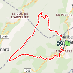
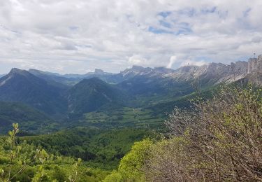
Tour Wandern von 9,7 km verfügbar auf Auvergne-Rhone-Alpen, Isère, Miribel-Lanchâtre. Diese Tour wird von patjobou vorgeschlagen.
Beschreibung
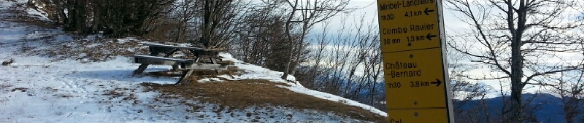
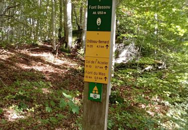
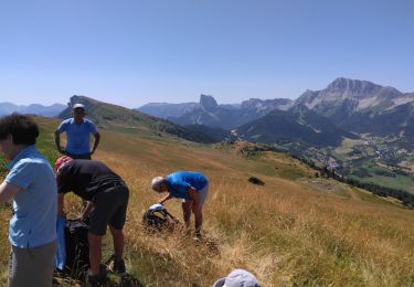
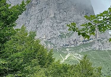
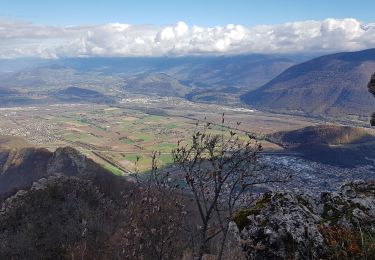
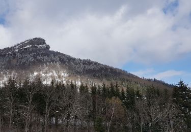
Belle boucle; la pente est plus raide sur la partie Nord; il vaut mieux tourner dans le sens inverse des aiguilles d'une montre; dans ce sens la montée est soutenue. Belle vue à 360° au sommet, au niveau de la clairière. Légère neige au sol.
Refaite en Nov 2017 dans les mêmes conditions.
Ort
Kommentare
Touren in der Umgebung
![Tour Wandern Château-Bernard - la soldanelle - Photo](https://media.geolcdn.com/t/375/260/75f3f6c9-7fa9-4e53-8263-c310156b3409.jpg&format=jpg&maxdim=2)
![Wandern Wandern](https://static1.geolcdn.com/sitytour/trail-icons/101.png)
Wandern
![](/images/other/stat-length.png)
![](https://static1.geolcdn.com/siteimages/upload/files/16400158638029165_repeat_loop_refresh_sync_direction_icon.png)
![Tour Wandern Château-Bernard - tête des chaudières et rocher de la Balme - Photo](https://media.geolcdn.com/t/375/260/0195d12b-3165-4d3f-81a6-2df422d450fa.jpg&format=jpg&maxdim=2)
![Wandern Wandern](https://static1.geolcdn.com/sitytour/trail-icons/101.png)
Wandern
![](/images/other/stat-length.png)
![](https://static1.geolcdn.com/siteimages/upload/files/16400158638029165_repeat_loop_refresh_sync_direction_icon.png)
![Tour Wandern Saint-Guillaume - Rando de la Montagne de la Pâle - Photo](https://media.geolcdn.com/t/375/260/58496464-99a1-4508-832d-153331e34cae.jpg&format=jpg&maxdim=2)
![Wandern Wandern](https://static1.geolcdn.com/sitytour/trail-icons/101.png)
Wandern
![](/images/other/stat-length.png)
![](https://static1.geolcdn.com/siteimages/upload/files/16400158638029165_repeat_loop_refresh_sync_direction_icon.png)
![Tour Wandern Château-Bernard - sous pas Balme de Arzelier - Photo](https://media.geolcdn.com/t/375/260/ad496dd6-d014-4fff-96cc-8f3a271c17a6.jpg&format=jpg&maxdim=2)
![Wandern Wandern](https://static1.geolcdn.com/sitytour/trail-icons/101.png)
Wandern
![](/images/other/stat-length.png)
![](https://static1.geolcdn.com/siteimages/upload/files/16400158638029165_repeat_loop_refresh_sync_direction_icon.png)
![Tour Wandern Avignonet - Circuit des 3 Châteaux - Photo](https://media.geolcdn.com/t/375/260/89ca6681-2cd7-4118-9588-52e735372338.jpg&format=jpg&maxdim=2)
![Wandern Wandern](https://static1.geolcdn.com/sitytour/trail-icons/101.png)
Wandern
![](/images/other/stat-length.png)
![](https://static1.geolcdn.com/siteimages/upload/files/16400158638029165_repeat_loop_refresh_sync_direction_icon.png)
![Tour Wandern Le Gua - Le Pieu depuis Les Petits Amieux - Photo](https://media.geolcdn.com/t/375/260/bc0f1a32-2a26-4597-a0e3-8997a2b8a6b8.jpg&format=jpg&maxdim=2)
![Wandern Wandern](https://static1.geolcdn.com/sitytour/trail-icons/101.png)
Wandern
![](/images/other/stat-length.png)
![](https://static1.geolcdn.com/siteimages/upload/files/16400158638029165_repeat_loop_refresh_sync_direction_icon.png)
![Tour Wandern Le Gua - Tour des arêtes du Gerbier - Photo](https://media.geolcdn.com/t/375/260/e28f2edb-9b96-4c03-9a1e-b9e1e5dfdb76.jpg&format=jpg&maxdim=2)
![Wandern Wandern](https://static1.geolcdn.com/sitytour/trail-icons/101.png)
Wandern
![](/images/other/stat-length.png)
![](https://static1.geolcdn.com/siteimages/upload/files/16400158638029165_repeat_loop_refresh_sync_direction_icon.png)
![Tour Wandern Château-Bernard - Le Pas de La Balme depuis le Col de l Arzelier - Photo](https://media.geolcdn.com/t/375/260/2f2a8518-f240-4e56-89cb-15c3915e072a.jpg&format=jpg&maxdim=2)
![Wandern Wandern](https://static1.geolcdn.com/sitytour/trail-icons/101.png)
Wandern
![](/images/other/stat-length.png)
![](https://static1.geolcdn.com/siteimages/upload/files/16400158638029165_repeat_loop_refresh_sync_direction_icon.png)
![Tour Wandern Le Gua - L'Eperrimont ou l'Indien en mode hivernal - Photo](https://media.geolcdn.com/t/375/260/14d17471-c49b-4ce8-9fe1-a90ccbaf7a8b.jpg&format=jpg&maxdim=2)
![Wandern Wandern](https://static1.geolcdn.com/sitytour/trail-icons/101.png)
Wandern
![](/images/other/stat-length.png)
![](https://static1.geolcdn.com/siteimages/upload/files/16400158638029165_repeat_loop_refresh_sync_direction_icon.png)