![](/images/other/stat-length.png)
![Tour Wandern Nassogne - forrieres - Photo](https://media.geolcdn.com/t/1900/400/ext.pjpeg?maxdim=2&url=https%3A%2F%2Fstatic1.geolcdn.com%2Fsiteimages%2Fupload%2Ffiles%2F1553511878bg_sport_marche.png)
forrieres
Wernerch
Benutzer
![Länge](/images/other/stat-length.png)
Länge
11,2 km
![Maximale Höhe](https://static1.geolcdn.com/siteimages/upload/files/1508320355ic_sort_altitude_max_24dp.png)
Maximale Höhe
360 m
![Positive Höhendifferenz](https://static1.geolcdn.com/siteimages/upload/files/1508320355ic_sort_den_pos_24dp.png)
Positive Höhendifferenz
345 m
![Km-Effort](/images/other/stat-length.png)
Km-Effort
15,8 km
![Min. Höhe](https://static1.geolcdn.com/siteimages/upload/files/1508320355ic_sort_altitude_min_24dp.png)
Min. Höhe
199 m
![Negative Höhendifferenz](https://static1.geolcdn.com/siteimages/upload/files/1508320355ic_sort_den_neg_24dp.png)
Negative Höhendifferenz
345 m
![Boucle](https://static1.geolcdn.com/siteimages/upload/files/16400158638029165_repeat_loop_refresh_sync_direction_icon.png)
Boucle
Ja
Erstellungsdatum :
2017-02-12 00:00:00.0
Letzte Änderung :
2017-02-12 00:00:00.0
![Wandern](https://static1.geolcdn.com/sitytour/trail-icons/101.png)
2h54
Schwierigkeit : Medium
![Scannen Sie diesen QR-Code, um die Tour in der SityTrail-Anwendung zu öffnen](https://capi.geolives.com/qq0zvz2zws4bq2lad0pu/sitytour/trails/680615/qr.png?size=200)
Kostenlosegpshiking-Anwendung
Über SityTrail
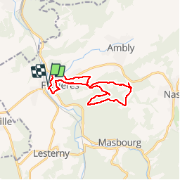
Tour Wandern von 11,2 km verfügbar auf Wallonien, Luxemburg, Nassogne. Diese Tour wird von Wernerch vorgeschlagen.
Beschreibung
D&part de l'église de Forrières. Un petit échauffement avant d'attaquer la première difficulté- la Chavée-et ensuite un beau tronçon boisé.
Nous sommes passés dire bonjour aux walabis avant le retour par l'orée du bois des Eyîs et redescendre vers le point de départ.
Ort
Land:
Belgium
Region :
Wallonien
Abteilung/Provinz :
Luxemburg
Kommune :
Nassogne
Standort:
Forrières
Gehen Sie:(Dec)
Gehen Sie:(UTM)
662849 ; 5555784 (31U) N.
Kommentare
Touren in der Umgebung
![Tour Motor Rochefort - Car tour - Heritage : churches, chapels and abbeys - Rochefort - Photo](https://media.geolcdn.com/t/375/260/ext.jpg?maxdim=2&url=https%3A%2F%2Fservices.sitytrail.com%2FGeolivesWS%2FDownloadMedia.ashx%3FTrailID%3D153103%26Media%3D05603f1b-9f7c-481f-bc84-6cc819555dbb.jpg)
![Motor Motor](https://static1.geolcdn.com/sitytour/trail-icons/400.png)
Car tour - Heritage : churches, chapels and abbeys - Rochefort
Motor
Einfach
(5)
Rochefort,
Wallonien,
Namur,
Belgium
![](/images/other/stat-length.png)
65 km | 78 km-effort
2h 40min
![](https://static1.geolcdn.com/siteimages/upload/files/16400158638029165_repeat_loop_refresh_sync_direction_icon.png)
Ja
![Tour Wandern Rochefort - GG2-Lu-34_Jemelle-Marche-en-Famenne (2021-11-04) - Photo](https://media.geolcdn.com/t/375/260/ext.jpg?maxdim=2&url=https%3A%2F%2Fmedia.geolcdn.com%2Ff%2F91b7d059-d006-40d3-874c-d8599db21b3d.gpx)
![Wandern Wandern](https://static1.geolcdn.com/sitytour/trail-icons/101.png)
GG2-Lu-34_Jemelle-Marche-en-Famenne (2021-11-04)
Wandern
Medium
(1)
Rochefort,
Wallonien,
Namur,
Belgium
![](/images/other/stat-length.png)
19,2 km | 24 km-effort
5h 32min
![](https://static1.geolcdn.com/siteimages/upload/files/16400158638029165_repeat_loop_refresh_sync_direction_icon.png)
Nein
![Tour Wandern Tellin - GG-Lu-13_Grupont - Poix-Saint-Hubert - Photo](https://media.geolcdn.com/t/375/260/ext.jpg?maxdim=2&url=https%3A%2F%2Fmedia.geolcdn.com%2Ff%2F5959367f-35e5-42da-bbcc-7bf6a947c3d1.jpg)
![Wandern Wandern](https://static1.geolcdn.com/sitytour/trail-icons/101.png)
GG-Lu-13_Grupont - Poix-Saint-Hubert
Wandern
Sehr schwierig
(2)
Tellin,
Wallonien,
Luxemburg,
Belgium
![](/images/other/stat-length.png)
26 km | 34 km-effort
7h 23min
![](https://static1.geolcdn.com/siteimages/upload/files/16400158638029165_repeat_loop_refresh_sync_direction_icon.png)
Nein
![Tour Wandern Tellin - Balade à Grupont - Photo](https://media.geolcdn.com/t/375/260/ext.jpg?maxdim=2&url=https%3A%2F%2Fservices.sitytrail.com%2FGeolivesWS%2FDownloadMedia.ashx%3FTrailID%3D963883%26Media%3D35fabe2c-0877-4435-b4f9-1ab0863175f9.jpg)
![Wandern Wandern](https://static1.geolcdn.com/sitytour/trail-icons/101.png)
Balade à Grupont
Wandern
Einfach
(1)
Tellin,
Wallonien,
Luxemburg,
Belgium
![](/images/other/stat-length.png)
8,4 km | 11,9 km-effort
2h 33min
![](https://static1.geolcdn.com/siteimages/upload/files/16400158638029165_repeat_loop_refresh_sync_direction_icon.png)
Ja
![Tour Wandern Tellin - Bure - Promenade des chapelles - Photo](https://media.geolcdn.com/t/375/260/ext.jpg?maxdim=2&url=https%3A%2F%2Fservices.sitytrail.com%2FGeolivesWS%2FDownloadMedia.ashx%3FTrailID%3D551016%26Media%3D367a68c9-5f59-4fbe-aa6c-c01d282ce6b9.jpg)
![Wandern Wandern](https://static1.geolcdn.com/sitytour/trail-icons/101.png)
Bure - Promenade des chapelles
Wandern
Einfach
(1)
Tellin,
Wallonien,
Luxemburg,
Belgium
![](/images/other/stat-length.png)
4,5 km | 5,9 km-effort
1h 15min
![](https://static1.geolcdn.com/siteimages/upload/files/16400158638029165_repeat_loop_refresh_sync_direction_icon.png)
Ja
![Tour Motor Rochefort - Roadbook](https://media.geolcdn.com/t/375/260/ext.jpg?maxdim=2&url=https%3A%2F%2Fservices.sitytrail.com%2FGeolivesWS%2FDownloadMedia.ashx%3FTrailID%3D428715%26Media%3Dff47641a-75c9-4285-926b-b7008d6e40b8.png)
![Motor Motor](https://static1.geolcdn.com/sitytour/trail-icons/400.png)
Roadbook "On the road by car/motorbike" - "Local delicacies, crafts and tradi...
Motor
Sehr leicht
(3)
Rochefort,
Wallonien,
Namur,
Belgium
![](/images/other/stat-length.png)
140 km | 169 km-effort
2h 0min
![](https://static1.geolcdn.com/siteimages/upload/files/16400158638029165_repeat_loop_refresh_sync_direction_icon.png)
Ja
![Tour Wandern Tellin - Grupont - Promenade du Bois du Machi (EN) - Photo](https://media.geolcdn.com/t/375/260/ext.jpg?maxdim=2&url=https%3A%2F%2Fservices.sitytrail.com%2FGeolivesWS%2FDownloadMedia.ashx%3FTrailID%3D334604%26Media%3Dcf0f2910-0190-4469-9f88-d94c6a2716b3.jpg)
![Wandern Wandern](https://static1.geolcdn.com/sitytour/trail-icons/101.png)
Grupont - Promenade du Bois du Machi (EN)
Wandern
Medium
(1)
Tellin,
Wallonien,
Luxemburg,
Belgium
![](/images/other/stat-length.png)
8,6 km | 12,6 km-effort
2h 37min
![](https://static1.geolcdn.com/siteimages/upload/files/16400158638029165_repeat_loop_refresh_sync_direction_icon.png)
Ja
![Tour Wandern Tellin - Bure - Promenade du pont des Clôyes - Photo](https://media.geolcdn.com/t/375/260/ext.jpg?maxdim=2&url=https%3A%2F%2Fservices.sitytrail.com%2FGeolivesWS%2FDownloadMedia.ashx%3FTrailID%3D334602%26Media%3D8e0d2c95-f7df-4bf3-a998-440fe6cfb5b4.jpg)
![Wandern Wandern](https://static1.geolcdn.com/sitytour/trail-icons/101.png)
Bure - Promenade du pont des Clôyes
Wandern
Medium
(1)
Tellin,
Wallonien,
Luxemburg,
Belgium
![](/images/other/stat-length.png)
6,9 km | 9 km-effort
1h 59min
![](https://static1.geolcdn.com/siteimages/upload/files/16400158638029165_repeat_loop_refresh_sync_direction_icon.png)
Ja
![Tour Mountainbike Nassogne - Nassogne - Circuit VTT rouge 4 - Photo](https://media.geolcdn.com/t/375/260/ext.jpg?maxdim=2&url=https%3A%2F%2Fservices.sitytrail.com%2FGeolivesWS%2FDownloadMedia.ashx%3FTrailID%3D334498%26Media%3D7e3b25c4-69c3-43b8-9aff-2ac9aa518f72.jpg)
![Mountainbike Mountainbike](https://static1.geolcdn.com/sitytour/trail-icons/202.png)
Nassogne - Circuit VTT rouge 4
Mountainbike
Schwierig
(1)
Nassogne,
Wallonien,
Luxemburg,
Belgium
![](/images/other/stat-length.png)
26 km | 36 km-effort
2h 16min
![](https://static1.geolcdn.com/siteimages/upload/files/16400158638029165_repeat_loop_refresh_sync_direction_icon.png)
Ja