![](/images/other/stat-length.png)
![Tour Wandern Welkenrath - Henri-Chapelle-Cimetière Américain. - Photo](https://media.geolcdn.com/t/1900/400/ext.pjpeg?maxdim=2&url=https%3A%2F%2Fstatic1.geolcdn.com%2Fsiteimages%2Fupload%2Ffiles%2F1553511878bg_sport_marche.png)
Henri-Chapelle-Cimetière Américain.
rogo112
Benutzer
![Länge](/images/other/stat-length.png)
Länge
13,5 km
![Maximale Höhe](https://static1.geolcdn.com/siteimages/upload/files/1508320355ic_sort_altitude_max_24dp.png)
Maximale Höhe
344 m
![Positive Höhendifferenz](https://static1.geolcdn.com/siteimages/upload/files/1508320355ic_sort_den_pos_24dp.png)
Positive Höhendifferenz
225 m
![Km-Effort](/images/other/stat-length.png)
Km-Effort
16,5 km
![Min. Höhe](https://static1.geolcdn.com/siteimages/upload/files/1508320355ic_sort_altitude_min_24dp.png)
Min. Höhe
254 m
![Negative Höhendifferenz](https://static1.geolcdn.com/siteimages/upload/files/1508320355ic_sort_den_neg_24dp.png)
Negative Höhendifferenz
225 m
![Boucle](https://static1.geolcdn.com/siteimages/upload/files/16400158638029165_repeat_loop_refresh_sync_direction_icon.png)
Boucle
Ja
Erstellungsdatum :
2017-01-01 00:00:00.0
Letzte Änderung :
2017-01-01 00:00:00.0
![Wandern](https://static1.geolcdn.com/sitytour/trail-icons/101.png)
3h05
Schwierigkeit : Medium
![Scannen Sie diesen QR-Code, um die Tour in der SityTrail-Anwendung zu öffnen](https://capi.geolives.com/qq0zvz2zws4bq2lad0pu/sitytour/trails/678281/qr.png?size=200)
Kostenlosegpshiking-Anwendung
Über SityTrail
Tour Wandern von 13,5 km verfügbar auf Wallonien, Lüttich, Welkenrath. Diese Tour wird von rogo112 vorgeschlagen.
Beschreibung
Les hauteurs d'Henri Chapelle via le bois de Hees et le cimetière américain.
(Asphalte,prairies et chemins partiellement boueux).
Ort
Land:
Belgium
Region :
Wallonien
Abteilung/Provinz :
Lüttich
Kommune :
Welkenrath
Standort:
Henri-Chapelle
Gehen Sie:(Dec)
Gehen Sie:(UTM)
707141 ; 5617969 (31U) N.
Kommentare
Touren in der Umgebung
![Tour Wandern Thimister-Clermont - Froidthier - Photo](https://media.geolcdn.com/t/375/260/ext.jpg?maxdim=2&url=https%3A%2F%2Fmedia.geolcdn.com%2Ff%2F9142f7fe-feb5-4533-8005-65992f1c4338.jpg)
![Wandern Wandern](https://static1.geolcdn.com/sitytour/trail-icons/101.png)
Froidthier
Wandern
Einfach
(1)
Thimister-Clermont,
Wallonien,
Lüttich,
Belgium
![](/images/other/stat-length.png)
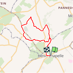
6,6 km | 7,9 km-effort
1h 48min
![](https://static1.geolcdn.com/siteimages/upload/files/16400158638029165_repeat_loop_refresh_sync_direction_icon.png)
Ja
![Tour Wandern Bleiberg - 20220428 - Bois de Hess 6.7 Km - Photo](https://media.geolcdn.com/t/375/260/ext.jpg?maxdim=2&url=https%3A%2F%2Fmedia.geolcdn.com%2Ff%2Fa5b9728a-379a-44f7-9b32-760730404ded.JPG)
![Wandern Wandern](https://static1.geolcdn.com/sitytour/trail-icons/101.png)
20220428 - Bois de Hess 6.7 Km
Wandern
Medium
(1)
Bleiberg,
Wallonien,
Lüttich,
Belgium
![](/images/other/stat-length.png)
6,7 km | 8,4 km-effort
3h 11min
![](https://static1.geolcdn.com/siteimages/upload/files/16400158638029165_repeat_loop_refresh_sync_direction_icon.png)
Ja
![Tour Wandern Lontzen - 2021-05-03_18h55m44_herbesthal - Photo](https://media.geolcdn.com/t/375/260/ext.jpg?maxdim=2&url=https%3A%2F%2Fmedia.geolcdn.com%2Ff%2Ff329bf39-b33b-4890-a8af-1e7d956ba015.jpg)
![Wandern Wandern](https://static1.geolcdn.com/sitytour/trail-icons/101.png)
2021-05-03_18h55m44_herbesthal
Wandern
Einfach
(2)
Lontzen,
Wallonien,
Lüttich,
Belgium
![](/images/other/stat-length.png)
13,4 km | 15,8 km-effort
3h 35min
![](https://static1.geolcdn.com/siteimages/upload/files/16400158638029165_repeat_loop_refresh_sync_direction_icon.png)
Ja
![Tour Wandern Aubel - RB-Lg-04 - Raccourci - À travers le bocage aubelois - Photo](https://media.geolcdn.com/t/375/260/ext.jpg?maxdim=2&url=https%3A%2F%2Fservices.sitytrail.com%2FGeolivesWS%2FDownloadMedia.ashx%3FTrailID%3D209393%26Media%3D9ac6c0af-9a08-4948-b5d5-06a09e8ba132.jpg)
![Wandern Wandern](https://static1.geolcdn.com/sitytour/trail-icons/101.png)
RB-Lg-04 - Raccourci - À travers le bocage aubelois
Wandern
Medium
(3)
Aubel,
Wallonien,
Lüttich,
Belgium
![](/images/other/stat-length.png)
17,1 km | 22 km-effort
4h 50min
![](https://static1.geolcdn.com/siteimages/upload/files/16400158638029165_repeat_loop_refresh_sync_direction_icon.png)
Ja
![Tour Wandern Welkenrath - Promenade des deux Châteaux (5km) - Photo](https://media.geolcdn.com/t/375/260/ext.jpg?maxdim=2&url=https%3A%2F%2Fstatic1.geolcdn.com%2Fsiteimages%2Fupload%2Ffiles%2F1553511878bg_sport_marche.png)
![Wandern Wandern](https://static1.geolcdn.com/sitytour/trail-icons/101.png)
Promenade des deux Châteaux (5km)
Wandern
Sehr leicht
(2)
Welkenrath,
Wallonien,
Lüttich,
Belgium
![](/images/other/stat-length.png)
5,4 km | 6 km-effort
Unbekannt
![](https://static1.geolcdn.com/siteimages/upload/files/16400158638029165_repeat_loop_refresh_sync_direction_icon.png)
Ja
![Tour Wandern Bleiberg - Promenade autour de Moresnet (7km) - Photo](https://media.geolcdn.com/t/375/260/ext.jpg?maxdim=2&url=https%3A%2F%2Fstatic1.geolcdn.com%2Fsiteimages%2Fupload%2Ffiles%2F1553511878bg_sport_marche.png)
![Wandern Wandern](https://static1.geolcdn.com/sitytour/trail-icons/101.png)
Promenade autour de Moresnet (7km)
Wandern
Sehr leicht
(1)
Bleiberg,
Wallonien,
Lüttich,
Belgium
![](/images/other/stat-length.png)
6,9 km | 8,7 km-effort
Unbekannt
![](https://static1.geolcdn.com/siteimages/upload/files/16400158638029165_repeat_loop_refresh_sync_direction_icon.png)
Ja
![Tour Wandern Bleiberg - 20230518 - Balade ornithologique MORESNET Village - 5 Km - Photo](https://media.geolcdn.com/t/375/260/ext.jpg?maxdim=2&url=https%3A%2F%2Fmedia.geolcdn.com%2Ff%2Fe916bcb8-f81b-482a-b372-2c9e52280cd8.jpeg)
![Wandern Wandern](https://static1.geolcdn.com/sitytour/trail-icons/101.png)
20230518 - Balade ornithologique MORESNET Village - 5 Km
Wandern
Einfach
Bleiberg,
Wallonien,
Lüttich,
Belgium
![](/images/other/stat-length.png)
5 km | 5,6 km-effort
2h 35min
![](https://static1.geolcdn.com/siteimages/upload/files/16400158638029165_repeat_loop_refresh_sync_direction_icon.png)
Ja
![Tour Wandern Thimister-Clermont - 20221219 - Thimister 7.7 Km - Photo](https://media.geolcdn.com/t/375/260/ext.jpg?maxdim=2&url=https%3A%2F%2Fmedia.geolcdn.com%2Ff%2F3807267e-0351-4366-bb63-c0a72cf91378.jpg)
![Wandern Wandern](https://static1.geolcdn.com/sitytour/trail-icons/101.png)
20221219 - Thimister 7.7 Km
Wandern
Medium
Thimister-Clermont,
Wallonien,
Lüttich,
Belgium
![](/images/other/stat-length.png)
7,5 km | 9,2 km-effort
Unbekannt
![](https://static1.geolcdn.com/siteimages/upload/files/16400158638029165_repeat_loop_refresh_sync_direction_icon.png)
Ja
![Tour Wandern Bleiberg - 20220731 - Montzen - 8.7 Km - Photo](https://media.geolcdn.com/t/375/260/ext.jpg?maxdim=2&url=https%3A%2F%2Fmedia.geolcdn.com%2Ff%2F77a1be7c-cec6-4949-b04d-135cea679147.JPG)
![Wandern Wandern](https://static1.geolcdn.com/sitytour/trail-icons/101.png)
20220731 - Montzen - 8.7 Km
Wandern
Medium
Bleiberg,
Wallonien,
Lüttich,
Belgium
![](/images/other/stat-length.png)
8,7 km | 10,7 km-effort
6h 52min
![](https://static1.geolcdn.com/siteimages/upload/files/16400158638029165_repeat_loop_refresh_sync_direction_icon.png)
Ja