![](/images/other/stat-length.png)
![Tour Mountainbike Bondoufle - 2016-11-17 autour de Lardy avec tour de pocancy et cabane ILEX - Photo](https://media.geolcdn.com/t/1900/400/ext.pjpeg?maxdim=2&url=https%3A%2F%2Fservices.sitytrail.com%2FGeolivesWS%2FDownloadMedia.ashx%3FTrailID%3D670852%26Media%3Dfix__20161117165815.jpg)
2016-11-17 autour de Lardy avec tour de pocancy et cabane ILEX
Lucquiaud
Benutzer
![Länge](/images/other/stat-length.png)
Länge
48 km
![Maximale Höhe](https://static1.geolcdn.com/siteimages/upload/files/1508320355ic_sort_altitude_max_24dp.png)
Maximale Höhe
163 m
![Positive Höhendifferenz](https://static1.geolcdn.com/siteimages/upload/files/1508320355ic_sort_den_pos_24dp.png)
Positive Höhendifferenz
389 m
![Km-Effort](/images/other/stat-length.png)
Km-Effort
53 km
![Min. Höhe](https://static1.geolcdn.com/siteimages/upload/files/1508320355ic_sort_altitude_min_24dp.png)
Min. Höhe
57 m
![Negative Höhendifferenz](https://static1.geolcdn.com/siteimages/upload/files/1508320355ic_sort_den_neg_24dp.png)
Negative Höhendifferenz
392 m
![Boucle](https://static1.geolcdn.com/siteimages/upload/files/16400158638029165_repeat_loop_refresh_sync_direction_icon.png)
Boucle
Ja
Erstellungsdatum :
2018-09-15 15:04:42.63
Letzte Änderung :
2018-09-15 15:04:42.796
![Mountainbike](https://static1.geolcdn.com/sitytour/trail-icons/202.png)
2h59
Schwierigkeit : Medium
![Scannen Sie diesen QR-Code, um die Tour in der SityTrail-Anwendung zu öffnen](https://capi.geolives.com/qq0zvz2zws4bq2lad0pu/sitytour/trails/670852/qr.png?size=200)
Kostenlosegpshiking-Anwendung
Über SityTrail
Tour Mountainbike von 48 km verfügbar auf Île-de-France, Essonne, Bondoufle. Diese Tour wird von Lucquiaud vorgeschlagen.
Beschreibung
rando devant le château de Chamarande (détour possible), château de Gillevoisin, Tour de Pocancy et cabane ILEX, moulin de Goujon pour finir sur la Juine
Ort
Land:
France
Region :
Île-de-France
Abteilung/Provinz :
Essonne
Kommune :
Bondoufle
Standort:
Unknown
Gehen Sie:(Dec)
Gehen Sie:(UTM)
454058 ; 5384623 (31U) N.
Kommentare
Touren in der Umgebung
![Tour Wandern Écharcon - Autour de Vert le Petit - Photo](https://media.geolcdn.com/t/375/260/ext.jpg?maxdim=2&url=https%3A%2F%2Fservices.sitytrail.com%2FGeolivesWS%2FDownloadMedia.ashx%3FTrailID%3D102739%26Media%3D3871_4.jpg)
![Wandern Wandern](https://static1.geolcdn.com/sitytour/trail-icons/101.png)
Autour de Vert le Petit
Wandern
Medium
(1)
Écharcon,
Île-de-France,
Essonne,
France
![](/images/other/stat-length.png)
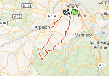
16 km | 17,9 km-effort
4h 0min
![](https://static1.geolcdn.com/siteimages/upload/files/16400158638029165_repeat_loop_refresh_sync_direction_icon.png)
Ja
![Tour Mountainbike Bondoufle - rando](https://media.geolcdn.com/t/375/260/ext.jpg?maxdim=2&url=https%3A%2F%2Fstatic1.geolcdn.com%2Fsiteimages%2Fupload%2Ffiles%2F1524743154velo.jpg)
![Mountainbike Mountainbike](https://static1.geolcdn.com/sitytour/trail-icons/202.png)
rando "sec" dimanche 07/02/2021
Mountainbike
Einfach
(1)
Bondoufle,
Île-de-France,
Essonne,
France
![](/images/other/stat-length.png)
56 km | 63 km-effort
8min
![](https://static1.geolcdn.com/siteimages/upload/files/16400158638029165_repeat_loop_refresh_sync_direction_icon.png)
Ja
![Tour Mountainbike Bondoufle - Senart - Photo](https://media.geolcdn.com/t/375/260/ext.jpg?maxdim=2&url=https%3A%2F%2Fstatic1.geolcdn.com%2Fsiteimages%2Fupload%2Ffiles%2F1524743154velo.jpg)
![Mountainbike Mountainbike](https://static1.geolcdn.com/sitytour/trail-icons/202.png)
Senart
Mountainbike
Sehr schwierig
(1)
Bondoufle,
Île-de-France,
Essonne,
France
![](/images/other/stat-length.png)
46 km | 52 km-effort
3h 30min
![](https://static1.geolcdn.com/siteimages/upload/files/16400158638029165_repeat_loop_refresh_sync_direction_icon.png)
Ja
![Tour Mountainbike Bondoufle - Sortie club du 29/09/2019 - Photo](https://media.geolcdn.com/t/375/260/ext.jpg?maxdim=2&url=https%3A%2F%2Fstatic1.geolcdn.com%2Fsiteimages%2Fupload%2Ffiles%2F1524743154velo.jpg)
![Mountainbike Mountainbike](https://static1.geolcdn.com/sitytour/trail-icons/202.png)
Sortie club du 29/09/2019
Mountainbike
Schwierig
(1)
Bondoufle,
Île-de-France,
Essonne,
France
![](/images/other/stat-length.png)
32 km | 36 km-effort
2h 25min
![](https://static1.geolcdn.com/siteimages/upload/files/16400158638029165_repeat_loop_refresh_sync_direction_icon.png)
Ja
![Tour Wandern Fleury-Mérogis - Fleury-Mérogis - Forêt Régionale de Saint-Eutrope - Photo](https://media.geolcdn.com/t/375/260/6448ff66-5599-4ef7-ab6f-bd578a291243.jpg&format=jpg&maxdim=2)
![Wandern Wandern](https://static1.geolcdn.com/sitytour/trail-icons/101.png)
Fleury-Mérogis - Forêt Régionale de Saint-Eutrope
Wandern
Einfach
Fleury-Mérogis,
Île-de-France,
Essonne,
France
![](/images/other/stat-length.png)
6,3 km | 7 km-effort
1h 35min
![](https://static1.geolcdn.com/siteimages/upload/files/16400158638029165_repeat_loop_refresh_sync_direction_icon.png)
Ja
![Tour Zu Fuß Soisy-sur-Seine - Boucle Soisy / Seine / Sénart - Photo](https://media.geolcdn.com/t/375/260/4a1feccf-2abe-4449-b3b1-c318219c819e.jpg&format=jpg&maxdim=2)
![Zu Fuß Zu Fuß](https://static1.geolcdn.com/sitytour/trail-icons/100.png)
Boucle Soisy / Seine / Sénart
Zu Fuß
Sehr leicht
Soisy-sur-Seine,
Île-de-France,
Essonne,
France
![](/images/other/stat-length.png)
18,6 km | 21 km-effort
4h 49min
![](https://static1.geolcdn.com/siteimages/upload/files/16400158638029165_repeat_loop_refresh_sync_direction_icon.png)
Ja
![Tour sport Mennecy - De Mennecy à Corbeil-Essonnes par le Parc de Robinson - Photo](https://media.geolcdn.com/t/375/260/ext.jpg?maxdim=2&url=https%3A%2F%2Fsecurestorage.geolives.com%2Fsitytour%2Ftrail-bg%2Fdefault.jpg)
De Mennecy à Corbeil-Essonnes par le Parc de Robinson
sport
Sehr leicht
(1)
Mennecy,
Île-de-France,
Essonne,
France
![](/images/other/stat-length.png)
13,1 km | 14,6 km-effort
Unbekannt
![](https://static1.geolcdn.com/siteimages/upload/files/16400158638029165_repeat_loop_refresh_sync_direction_icon.png)
Nein
![Tour Mountainbike Bondoufle - Autodrome - Photo](https://media.geolcdn.com/t/375/260/ext.jpg?maxdim=2&url=https%3A%2F%2Fstatic1.geolcdn.com%2Fsiteimages%2Fupload%2Ffiles%2F1524743154velo.jpg)
![Mountainbike Mountainbike](https://static1.geolcdn.com/sitytour/trail-icons/202.png)
Autodrome
Mountainbike
Sehr schwierig
(1)
Bondoufle,
Île-de-France,
Essonne,
France
![](/images/other/stat-length.png)
48 km | 54 km-effort
3h 44min
![](https://static1.geolcdn.com/siteimages/upload/files/16400158638029165_repeat_loop_refresh_sync_direction_icon.png)
Ja
![Tour Mountainbike Bondoufle - Bondoufle -Baulne 58KM - Photo](https://media.geolcdn.com/t/375/260/ext.jpg?maxdim=2&url=https%3A%2F%2Fstatic1.geolcdn.com%2Fsiteimages%2Fupload%2Ffiles%2F1524743154velo.jpg)
![Mountainbike Mountainbike](https://static1.geolcdn.com/sitytour/trail-icons/202.png)
Bondoufle -Baulne 58KM
Mountainbike
Einfach
(1)
Bondoufle,
Île-de-France,
Essonne,
France
![](/images/other/stat-length.png)
58 km | 66 km-effort
4h 34min
![](https://static1.geolcdn.com/siteimages/upload/files/16400158638029165_repeat_loop_refresh_sync_direction_icon.png)
Nein