![](/images/other/stat-length.png)
![Tour Wandern Saint-Laurent-des-Hommes - Forêt de la Double - Photo](https://media.geolcdn.com/t/1900/400/ext.pjpeg?maxdim=2&url=https%3A%2F%2Fstatic1.geolcdn.com%2Fsiteimages%2Fupload%2Ffiles%2F1553511878bg_sport_marche.png)
Forêt de la Double
gersimcar
Benutzer
![Länge](/images/other/stat-length.png)
Länge
29 km
![Maximale Höhe](https://static1.geolcdn.com/siteimages/upload/files/1508320355ic_sort_altitude_max_24dp.png)
Maximale Höhe
163 m
![Positive Höhendifferenz](https://static1.geolcdn.com/siteimages/upload/files/1508320355ic_sort_den_pos_24dp.png)
Positive Höhendifferenz
506 m
![Km-Effort](/images/other/stat-length.png)
Km-Effort
35 km
![Min. Höhe](https://static1.geolcdn.com/siteimages/upload/files/1508320355ic_sort_altitude_min_24dp.png)
Min. Höhe
46 m
![Negative Höhendifferenz](https://static1.geolcdn.com/siteimages/upload/files/1508320355ic_sort_den_neg_24dp.png)
Negative Höhendifferenz
493 m
![Boucle](https://static1.geolcdn.com/siteimages/upload/files/16400158638029165_repeat_loop_refresh_sync_direction_icon.png)
Boucle
Nein
Erstellungsdatum :
2014-12-10 00:00:00.0
Letzte Änderung :
2020-08-04 17:21:19.466
![Wandern](https://static1.geolcdn.com/sitytour/trail-icons/101.png)
8h00
Schwierigkeit : Medium
![Scannen Sie diesen QR-Code, um die Tour in der SityTrail-Anwendung zu öffnen](https://capi.geolives.com/qq0zvz2zws4bq2lad0pu/sitytour/trails/66813/qr.png?size=200)
Kostenlosegpshiking-Anwendung
Über SityTrail
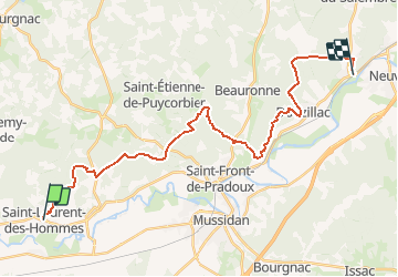
Tour Wandern von 29 km verfügbar auf Neu-Aquitanien, Dordogne, Saint-Laurent-des-Hommes. Diese Tour wird von gersimcar vorgeschlagen.
Beschreibung
Un voyage a travers la foret de la double sur le GR646 de st laurent des hommes a neuvic gare - temps du parcours 8 heures avec les arrets - chemin de st jacques. Ce parcours nécessite 2 voitures.
Ort
Land:
France
Region :
Neu-Aquitanien
Abteilung/Provinz :
Dordogne
Kommune :
Saint-Laurent-des-Hommes
Standort:
Unknown
Gehen Sie:(Dec)
Gehen Sie:(UTM)
283705 ; 4990716 (31T) N.
Kommentare
Touren in der Umgebung
![Tour Wandern Saint-Laurent-des-Hommes - boucle St Laurent des H 11km - Photo](https://media.geolcdn.com/t/375/260/ext.jpg?maxdim=2&url=https%3A%2F%2Fstatic1.geolcdn.com%2Fsiteimages%2Fupload%2Ffiles%2F1553511878bg_sport_marche.png)
![Wandern Wandern](https://static1.geolcdn.com/sitytour/trail-icons/101.png)
boucle St Laurent des H 11km
Wandern
Einfach
Saint-Laurent-des-Hommes,
Neu-Aquitanien,
Dordogne,
France
![](/images/other/stat-length.png)
11,3 km | 12,3 km-effort
3h 15min
![](https://static1.geolcdn.com/siteimages/upload/files/16400158638029165_repeat_loop_refresh_sync_direction_icon.png)
Ja