![](/images/other/stat-length.png)
![Tour Andere Aktivitäten Doullens - Nord - Pas-de-Calais - Ligne 306 - Doullens - Arras - Photo](https://media.geolcdn.com/t/1900/400/ext.pjpeg?maxdim=2&url=https%3A%2F%2Fstatic1.geolcdn.com%2Fsiteimages%2Fupload%2Ffiles%2F1545311037marcheuse_200dpi.jpg)
Nord - Pas-de-Calais - Ligne 306 - Doullens - Arras
mich54
Benutzer
![Länge](/images/other/stat-length.png)
Länge
35 km
![Maximale Höhe](https://static1.geolcdn.com/siteimages/upload/files/1508320355ic_sort_altitude_max_24dp.png)
Maximale Höhe
175 m
![Positive Höhendifferenz](https://static1.geolcdn.com/siteimages/upload/files/1508320355ic_sort_den_pos_24dp.png)
Positive Höhendifferenz
204 m
![Km-Effort](/images/other/stat-length.png)
Km-Effort
38 km
![Min. Höhe](https://static1.geolcdn.com/siteimages/upload/files/1508320355ic_sort_altitude_min_24dp.png)
Min. Höhe
60 m
![Negative Höhendifferenz](https://static1.geolcdn.com/siteimages/upload/files/1508320355ic_sort_den_neg_24dp.png)
Negative Höhendifferenz
200 m
![Boucle](https://static1.geolcdn.com/siteimages/upload/files/16400158638029165_repeat_loop_refresh_sync_direction_icon.png)
Boucle
Nein
Erstellungsdatum :
2016-11-21 00:00:00.0
Letzte Änderung :
2016-11-21 00:00:00.0
![Andere Aktivitäten](https://static1.geolcdn.com/sitytour/trail-icons/900.png)
5m
Schwierigkeit : Unbekannt
![Scannen Sie diesen QR-Code, um die Tour in der SityTrail-Anwendung zu öffnen](https://capi.geolives.com/qq0zvz2zws4bq2lad0pu/sitytour/trails/656044/qr.png?size=200)
Kostenlosegpshiking-Anwendung
Über SityTrail
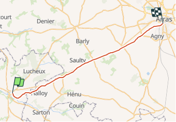
Tour Andere Aktivitäten von 35 km verfügbar auf Nordfrankreich, Somme, Doullens. Diese Tour wird von mich54 vorgeschlagen.
Beschreibung
La ligne de Doullens à Arras est une ancienne ligne ferroviaire française de la région Nord-Pas-de-Calais, à écartement standard et à voie unique, qui reliait la gare de Doullens à celle d'Arras. Elle est déclassée sur la majeure partie de son parcours.(Source Wikipédia)
Ort
Land:
France
Region :
Nordfrankreich
Abteilung/Provinz :
Somme
Kommune :
Doullens
Standort:
Unknown
Gehen Sie:(Dec)
Gehen Sie:(UTM)
453597 ; 5556405 (31U) N.
Kommentare
Touren in der Umgebung
![Tour Zu Fuß Beauval - Le Tortillard - Photo](https://media.geolcdn.com/t/375/260/fc38b3b2-b55e-4eec-a073-1b7b00356eed.jpeg&format=jpg&maxdim=2)
![Zu Fuß Zu Fuß](https://static1.geolcdn.com/sitytour/trail-icons/100.png)
Le Tortillard
Zu Fuß
Einfach
Beauval,
Nordfrankreich,
Somme,
France
![](/images/other/stat-length.png)
10,5 km | 11,9 km-effort
2h 42min
![](https://static1.geolcdn.com/siteimages/upload/files/16400158638029165_repeat_loop_refresh_sync_direction_icon.png)
Ja
![Tour Wandern Gézaincourt - Le chemin des vingt-deux - Gézaincourt - Photo](https://media.geolcdn.com/t/375/260/ext.jpg?maxdim=2&url=https%3A%2F%2Fservices.sitytrail.com%2FGeolivesWS%2FDownloadMedia.ashx%3FTrailID%3D173227%26Media%3D14830_3.jpg)
![Wandern Wandern](https://static1.geolcdn.com/sitytour/trail-icons/101.png)
Le chemin des vingt-deux - Gézaincourt
Wandern
Medium
Gézaincourt,
Nordfrankreich,
Somme,
France
![](/images/other/stat-length.png)
10,6 km | 12,4 km-effort
2h 30min
![](https://static1.geolcdn.com/siteimages/upload/files/16400158638029165_repeat_loop_refresh_sync_direction_icon.png)
Ja
![Tour Wandern Lucheux - Lucheux - l'allée royale - Photo](https://media.geolcdn.com/t/375/260/d33a1f93-d32b-49ee-8605-c826535d95d2.jpg&format=jpg&maxdim=2)
![Wandern Wandern](https://static1.geolcdn.com/sitytour/trail-icons/101.png)
Lucheux - l'allée royale
Wandern
Schwierig
Lucheux,
Nordfrankreich,
Somme,
France
![](/images/other/stat-length.png)
10,1 km | 12 km-effort
2h 44min
![](https://static1.geolcdn.com/siteimages/upload/files/16400158638029165_repeat_loop_refresh_sync_direction_icon.png)
Ja
![Tour Fahrrad Doullens - Le Doullennais - Photo](https://media.geolcdn.com/t/375/260/ext.jpg?maxdim=2&url=https%3A%2F%2Fservices.sitytrail.com%2FGeolivesWS%2FDownloadMedia.ashx%3FTrailID%3D109973%26Media%3D5054_1.jpg)
![Fahrrad Fahrrad](https://static1.geolcdn.com/sitytour/trail-icons/200.png)
Le Doullennais
Fahrrad
Schwierig
Doullens,
Nordfrankreich,
Somme,
France
![](/images/other/stat-length.png)
51 km | 58 km-effort
3h 30min
![](https://static1.geolcdn.com/siteimages/upload/files/16400158638029165_repeat_loop_refresh_sync_direction_icon.png)
Ja
![Tour Wandern Grouches-Luchuel - Grouches Luchuel - Photo](https://media.geolcdn.com/t/375/260/ext.jpg?maxdim=2&url=https%3A%2F%2Fstatic1.geolcdn.com%2Fsiteimages%2Fupload%2Ffiles%2F1553511878bg_sport_marche.png)
![Wandern Wandern](https://static1.geolcdn.com/sitytour/trail-icons/101.png)
Grouches Luchuel
Wandern
Einfach
Grouches-Luchuel,
Nordfrankreich,
Somme,
France
![](/images/other/stat-length.png)
14,6 km | 17,4 km-effort
3h 41min
![](https://static1.geolcdn.com/siteimages/upload/files/16400158638029165_repeat_loop_refresh_sync_direction_icon.png)
Ja
![Tour Andere Aktivitäten Doullens - Picardie - Ligne 306 - Doullens - Arras (Section Doullens Halloy) - Photo](https://media.geolcdn.com/t/375/260/ext.jpg?maxdim=2&url=https%3A%2F%2Fstatic1.geolcdn.com%2Fsiteimages%2Fupload%2Ffiles%2F1545311037marcheuse_200dpi.jpg)
![Andere Aktivitäten Andere Aktivitäten](https://static1.geolcdn.com/sitytour/trail-icons/900.png)
Picardie - Ligne 306 - Doullens - Arras (Section Doullens Halloy)
Andere Aktivitäten
Sehr leicht
Doullens,
Nordfrankreich,
Somme,
France
![](/images/other/stat-length.png)
7,9 km | 9,1 km-effort
5min
![](https://static1.geolcdn.com/siteimages/upload/files/16400158638029165_repeat_loop_refresh_sync_direction_icon.png)
Nein
![Tour Motor Lucheux - pas en Artois après midi 240313 - Photo](https://media.geolcdn.com/t/375/260/ext.jpg?maxdim=2&url=https%3A%2F%2Fstatic1.geolcdn.com%2Fsiteimages%2Fupload%2Ffiles%2F15247431544x4.jpg)
![Motor Motor](https://static1.geolcdn.com/sitytour/trail-icons/400.png)
pas en Artois après midi 240313
Motor
Schwierig
Lucheux,
Nordfrankreich,
Somme,
France
![](/images/other/stat-length.png)
33 km | 39 km-effort
2h 42min
![](https://static1.geolcdn.com/siteimages/upload/files/16400158638029165_repeat_loop_refresh_sync_direction_icon.png)
Nein