![](/images/other/stat-length.png)
![Tour Mountainbike Mellecey - chatenoy ke royal - ruly - Photo](https://media.geolcdn.com/t/1900/400/ext.pjpeg?maxdim=2&url=https%3A%2F%2Fstatic1.geolcdn.com%2Fsiteimages%2Fupload%2Ffiles%2F1524743154velo.jpg)
chatenoy ke royal - ruly
XavierFaidix
Benutzer
![Länge](/images/other/stat-length.png)
Länge
36 km
![Maximale Höhe](https://static1.geolcdn.com/siteimages/upload/files/1508320355ic_sort_altitude_max_24dp.png)
Maximale Höhe
392 m
![Positive Höhendifferenz](https://static1.geolcdn.com/siteimages/upload/files/1508320355ic_sort_den_pos_24dp.png)
Positive Höhendifferenz
599 m
![Km-Effort](/images/other/stat-length.png)
Km-Effort
44 km
![Min. Höhe](https://static1.geolcdn.com/siteimages/upload/files/1508320355ic_sort_altitude_min_24dp.png)
Min. Höhe
204 m
![Negative Höhendifferenz](https://static1.geolcdn.com/siteimages/upload/files/1508320355ic_sort_den_neg_24dp.png)
Negative Höhendifferenz
600 m
![Boucle](https://static1.geolcdn.com/siteimages/upload/files/16400158638029165_repeat_loop_refresh_sync_direction_icon.png)
Boucle
Ja
Erstellungsdatum :
2019-04-01 20:34:37.048
Letzte Änderung :
2019-04-01 20:34:37.121
![Mountainbike](https://static1.geolcdn.com/sitytour/trail-icons/202.png)
2h54
Schwierigkeit : Medium
![Scannen Sie diesen QR-Code, um die Tour in der SityTrail-Anwendung zu öffnen](https://capi.geolives.com/qq0zvz2zws4bq2lad0pu/sitytour/trails/652619/qr.png?size=200)
Kostenlosegpshiking-Anwendung
Über SityTrail
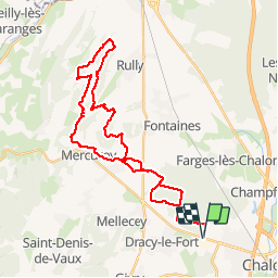
Tour Mountainbike von 36 km verfügbar auf Burgund und Freigrafschaft, Saône-et-Loire, Mellecey. Diese Tour wird von XavierFaidix vorgeschlagen.
Beschreibung
parcours roulant à l'allée et au retour dans le bois de marloux
beaux singles montant et descendant dans les sous bois
un portage dans les bois de ruly
Ort
Land:
France
Region :
Burgund und Freigrafschaft
Abteilung/Provinz :
Saône-et-Loire
Kommune :
Mellecey
Standort:
Unknown
Gehen Sie:(Dec)
Gehen Sie:(UTM)
636614 ; 5184568 (31T) N.
Kommentare
Touren in der Umgebung
![Tour Wandern Mellecey - SityTrail - G2 mellecey - Photo](https://media.geolcdn.com/t/375/260/ext.jpg?maxdim=2&url=https%3A%2F%2Fstatic1.geolcdn.com%2Fsiteimages%2Fupload%2Ffiles%2F1553511878bg_sport_marche.png)
![Wandern Wandern](https://static1.geolcdn.com/sitytour/trail-icons/101.png)
SityTrail - G2 mellecey
Wandern
Sehr schwierig
(1)
Mellecey,
Burgund und Freigrafschaft,
Saône-et-Loire,
France
![](/images/other/stat-length.png)
14,3 km | 19,4 km-effort
4h 25min
![](https://static1.geolcdn.com/siteimages/upload/files/16400158638029165_repeat_loop_refresh_sync_direction_icon.png)
Ja
![Tour Wandern Chalon-sur-Saône - Balade en bord de Saône à Chalon - Photo](https://media.geolcdn.com/t/375/260/8e4d7cac-cf9f-46b7-a64e-342de3a9e9d5.jpg&format=jpg&maxdim=2)
![Wandern Wandern](https://static1.geolcdn.com/sitytour/trail-icons/101.png)
Balade en bord de Saône à Chalon
Wandern
Einfach
Chalon-sur-Saône,
Burgund und Freigrafschaft,
Saône-et-Loire,
France
![](/images/other/stat-length.png)
5,6 km | 6,4 km-effort
1h 15min
![](https://static1.geolcdn.com/siteimages/upload/files/16400158638029165_repeat_loop_refresh_sync_direction_icon.png)
Ja
![Tour Wandern Chalon-sur-Saône - Chalon embouchure de la Thalie et retour - Photo](https://media.geolcdn.com/t/375/260/abde2e03-69c5-4324-8dc4-e3b5352ebee9.jpg&format=jpg&maxdim=2)
![Wandern Wandern](https://static1.geolcdn.com/sitytour/trail-icons/101.png)
Chalon embouchure de la Thalie et retour
Wandern
Einfach
Chalon-sur-Saône,
Burgund und Freigrafschaft,
Saône-et-Loire,
France
![](/images/other/stat-length.png)
7,3 km | 7,8 km-effort
1h 31min
![](https://static1.geolcdn.com/siteimages/upload/files/16400158638029165_repeat_loop_refresh_sync_direction_icon.png)
Ja
![Tour Wandern Chalon-sur-Saône - Chalon Port Guillot Lux sentier de la Thalie Chalon - Photo](https://media.geolcdn.com/t/375/260/afd7d2e3-221b-46d6-a2d7-5a57ba1a946c.jpg&format=jpg&maxdim=2)
![Wandern Wandern](https://static1.geolcdn.com/sitytour/trail-icons/101.png)
Chalon Port Guillot Lux sentier de la Thalie Chalon
Wandern
Einfach
Chalon-sur-Saône,
Burgund und Freigrafschaft,
Saône-et-Loire,
France
![](/images/other/stat-length.png)
9,7 km | 10,7 km-effort
1h 57min
![](https://static1.geolcdn.com/siteimages/upload/files/16400158638029165_repeat_loop_refresh_sync_direction_icon.png)
Ja
![Tour Wandern Givry - givry - Photo](https://media.geolcdn.com/t/375/260/360b2f11-9934-417f-b98c-2b811b09bd07.jpg&format=jpg&maxdim=2)
![Wandern Wandern](https://static1.geolcdn.com/sitytour/trail-icons/101.png)
givry
Wandern
Medium
Givry,
Burgund und Freigrafschaft,
Saône-et-Loire,
France
![](/images/other/stat-length.png)
6,6 km | 8,9 km-effort
2h 18min
![](https://static1.geolcdn.com/siteimages/upload/files/16400158638029165_repeat_loop_refresh_sync_direction_icon.png)
Ja
![Tour Wandern Givry - Boucle de Givry à Russilly - Photo](https://media.geolcdn.com/t/375/260/85246615-56a1-4d35-9f72-f13342515b10.jpg&format=jpg&maxdim=2)
![Wandern Wandern](https://static1.geolcdn.com/sitytour/trail-icons/101.png)
Boucle de Givry à Russilly
Wandern
Medium
Givry,
Burgund und Freigrafschaft,
Saône-et-Loire,
France
![](/images/other/stat-length.png)
12,2 km | 17,8 km-effort
2h 51min
![](https://static1.geolcdn.com/siteimages/upload/files/16400158638029165_repeat_loop_refresh_sync_direction_icon.png)
Ja
![Tour Mountainbike Chalon-sur-Saône - rando chaumes de givry av christppher - Photo](https://media.geolcdn.com/t/375/260/ext.jpg?maxdim=2&url=https%3A%2F%2Fservices.sitytrail.com%2FGeolivesWS%2FDownloadMedia.ashx%3FTrailID%3D411059%26Media%3Dfix__20150422163330.jpg)
![Mountainbike Mountainbike](https://static1.geolcdn.com/sitytour/trail-icons/202.png)
rando chaumes de givry av christppher
Mountainbike
Medium
(1)
Chalon-sur-Saône,
Burgund und Freigrafschaft,
Saône-et-Loire,
France
![](/images/other/stat-length.png)
31 km | 38 km-effort
2h 59min
![](https://static1.geolcdn.com/siteimages/upload/files/16400158638029165_repeat_loop_refresh_sync_direction_icon.png)
Ja
![Tour Wandern Givry - Givry - la chaume - Photo](https://media.geolcdn.com/t/375/260/ext.jpg?maxdim=2&url=https%3A%2F%2Fstatic1.geolcdn.com%2Fsiteimages%2Fupload%2Ffiles%2F1553511878bg_sport_marche.png)
![Wandern Wandern](https://static1.geolcdn.com/sitytour/trail-icons/101.png)
Givry - la chaume
Wandern
Medium
(1)
Givry,
Burgund und Freigrafschaft,
Saône-et-Loire,
France
![](/images/other/stat-length.png)
7,2 km | 10,3 km-effort
Unbekannt
![](https://static1.geolcdn.com/siteimages/upload/files/16400158638029165_repeat_loop_refresh_sync_direction_icon.png)
Ja
![Tour Wandern Givry - givry rst - Photo](https://media.geolcdn.com/t/375/260/8f3e89ce-e3cb-45d0-8925-9c51c3bc5a4d.jpg&format=jpg&maxdim=2)
![Wandern Wandern](https://static1.geolcdn.com/sitytour/trail-icons/101.png)
givry rst
Wandern
Medium
Givry,
Burgund und Freigrafschaft,
Saône-et-Loire,
France
![](/images/other/stat-length.png)
16,1 km | 21 km-effort
6h 51min
![](https://static1.geolcdn.com/siteimages/upload/files/16400158638029165_repeat_loop_refresh_sync_direction_icon.png)
Nein