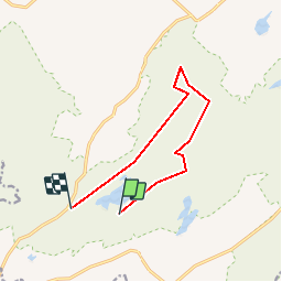
Tour Wandern West Clare Municipal District - MullaghMore - Photo
© OpenStreetMap contributors
Länge
Länge
8,7 km
Maximale Höhe
Maximale Höhe
196 m
Positive Höhendifferenz
274 m
Km-Effort
Km-Effort  
12,3 km
Min. Höhe
Min. Höhe
30 m
Negative Höhendifferenz
271 m
Boucle
Boucle
Nein
Erstellungsdatum :
2014-12-10 00:00:00.0
Letzte Änderung :
2014-12-10 00:00:00.0

(0 Nachricht)

Wandern
Wandern
--
Schwierigkeit : Medium

Scannen Sie diesen QR-Code, um die Tour in der SityTrail-Anwendung zu öffnen

Kostenlosegpshiking-Anwendung

Logo SityTrail SityTrail

IGN / Geografische Institute

SityTrail aus dem App Store herunterladen SityTrail von Google Play herunterladen

Logo SityTrail SityTrail World

Die Welt öffnet sich für Sie

SityTrail aus dem App Store herunterladen SityTrail von Google Play herunterladen SityTrail auf Huawei AppGallery herunterladen

Über SityTrail

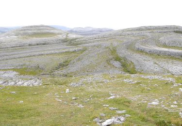
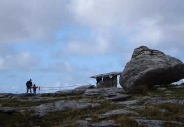
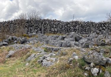
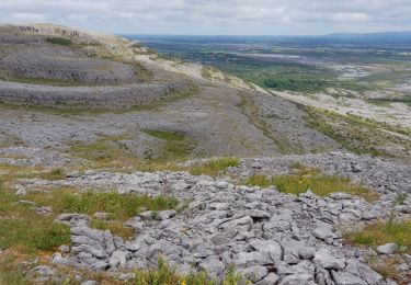
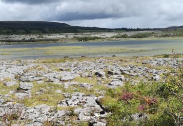
Tour Wandern von 8,7 km verfügbar auf Unbekannt, County Clare, West Clare Municipal District. Diese Tour wird von walter.hmcampbell vorgeschlagen.

Höhenprofil

POIs

POI West Clare Municipal District - Start - Photo
walter.hmcampbell
WEST CLARE MUNICIPAL DISTRICT 
POI West Clare Municipal District - Turn - Photo
walter.hmcampbell
WEST CLARE MUNICIPAL DISTRICT 
POI West Clare Municipal District - TurnSteps - Photo
walter.hmcampbell
WEST CLARE MUNICIPAL DISTRICT 
POI West Clare Municipal District - Mullagh - Photo
walter.hmcampbell
WEST CLARE MUNICIPAL DISTRICT 
POI West Clare Municipal District - Slieve Roe - Photo
walter.hmcampbell
WEST CLARE MUNICIPAL DISTRICT 
POI West Clare Municipal District - Ruins - Photo
walter.hmcampbell
WEST CLARE MUNICIPAL DISTRICT 
POI West Clare Municipal District - Knockanes - Photo
walter.hmcampbell
WEST CLARE MUNICIPAL DISTRICT 
POI West Clare Municipal District - OffSlope - Photo
walter.hmcampbell
WEST CLARE MUNICIPAL DISTRICT 
POI West Clare Municipal District - BluebellWd - Photo
walter.hmcampbell
WEST CLARE MUNICIPAL DISTRICT 
POI West Clare Municipal District - Tomb - Photo
walter.hmcampbell
WEST CLARE MUNICIPAL DISTRICT 
POI West Clare Municipal District - Cowslip - Photo
walter.hmcampbell
WEST CLARE MUNICIPAL DISTRICT 

Ort

Land:
Ireland
Region :
Unbekannt
Abteilung/Provinz :
County Clare
Kommune :
West Clare Municipal District
Standort:
Glenroe
Gehen Sie:(Dec)
Gehen Sie:(UTM)
498596 ; 5871825 (29U) N.

Touren in der Umgebung

Tour Wandern West Clare Municipal District - Burren - the blue and white trains - Photo
Wandern
Lobin

Wandern

Medium
West Clare Municipal District, Unbekannt, County Clare, Ireland
9,4 km | 12 km-effort
2h 43min
Ja
Tour Wandern West Clare Municipal District - 190705BurrenNationalPark - Photo
Wandern
pffrench

Wandern

Sehr leicht
West Clare Municipal District, Unbekannt, County Clare, Ireland
13,3 km | 16 km-effort
4h 48min
Nein
Tour Wandern West Clare Municipal District - J-27/06- CARRAN LOOP WALK - 9,5 KM - Photo
Wandern
GUIDE
jeanmarcMasson

Wandern

Medium
West Clare Municipal District, Unbekannt, County Clare, Ireland
9,6 km | 11,7 km-effort
2h 39min
Ja
Tour Wandern West Clare Municipal District - LOUGH AVALLA - Photo
Wandern
GUIDE
jeanmarcMasson

Wandern

Medium
West Clare Municipal District, Unbekannt, County Clare, Ireland
8,2 km | 10,2 km-effort
2h 18min
Ja
Tour Wandern West Clare Municipal District - Mon parcours - Photo
Wandern
BureauChris

Wandern

Medium
(1)
West Clare Municipal District, Unbekannt, County Clare, Ireland
7,5 km | 9,8 km-effort
2h 5min
Ja
Tour Auto West Clare Municipal District - 190705BurrenConnemara - Photo
Auto
pffrench

Auto

Sehr leicht
West Clare Municipal District, Unbekannt, County Clare, Ireland
168 km | 187 km-effort
6h 52min
Nein


Schließen
Meine Abonnements