![](/images/other/stat-length.png)
![Tour Wandern Stekene - Stiltegebied Klein Sinaai ( 9,5 km) StepAway.be - Photo](https://media.geolcdn.com/t/1900/400/ext.pjpeg?maxdim=2&url=https%3A%2F%2Fstatic1.geolcdn.com%2Fsiteimages%2Fupload%2Ffiles%2F1553511878bg_sport_marche.png)
Stiltegebied Klein Sinaai ( 9,5 km) StepAway.be
corry.vandenbroeke
Benutzer
![Länge](/images/other/stat-length.png)
Länge
9,7 km
![Maximale Höhe](https://static1.geolcdn.com/siteimages/upload/files/1508320355ic_sort_altitude_max_24dp.png)
Maximale Höhe
9 m
![Positive Höhendifferenz](https://static1.geolcdn.com/siteimages/upload/files/1508320355ic_sort_den_pos_24dp.png)
Positive Höhendifferenz
46 m
![Km-Effort](/images/other/stat-length.png)
Km-Effort
10,3 km
![Min. Höhe](https://static1.geolcdn.com/siteimages/upload/files/1508320355ic_sort_altitude_min_24dp.png)
Min. Höhe
0 m
![Negative Höhendifferenz](https://static1.geolcdn.com/siteimages/upload/files/1508320355ic_sort_den_neg_24dp.png)
Negative Höhendifferenz
45 m
![Boucle](https://static1.geolcdn.com/siteimages/upload/files/16400158638029165_repeat_loop_refresh_sync_direction_icon.png)
Boucle
Ja
Erstellungsdatum :
2016-10-26 00:00:00.0
Letzte Änderung :
2016-10-26 00:00:00.0
![Wandern](https://static1.geolcdn.com/sitytour/trail-icons/101.png)
2h18
Schwierigkeit : Sehr leicht
![Scannen Sie diesen QR-Code, um die Tour in der SityTrail-Anwendung zu öffnen](https://capi.geolives.com/qq0zvz2zws4bq2lad0pu/sitytour/trails/651170/qr.png?size=200)
Kostenlosegpshiking-Anwendung
Über SityTrail
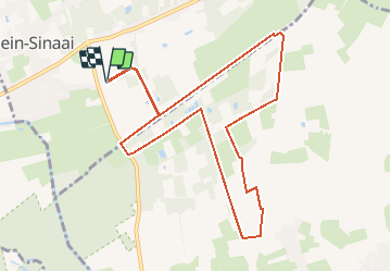
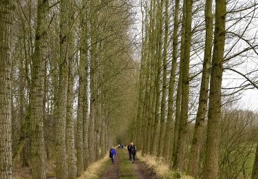
Tour Wandern von 9,7 km verfügbar auf Flandern, Ostflandern, Stekene. Diese Tour wird von corry.vandenbroeke vorgeschlagen.
Beschreibung
Start Klein sinaai. Helft van de wandeling verharde weg en dus niet echt geschikt voor Nordic walking. maar wel een heel mooi gebied. Wandeling uitgestippeld door StepAway.be
Ort
Land:
Belgium
Region :
Flandern
Abteilung/Provinz :
Ostflandern
Kommune :
Stekene
Standort:
Stekene
Gehen Sie:(Dec)
Gehen Sie:(UTM)
569918 ; 5670346 (31U) N.
Kommentare
Touren in der Umgebung
![Tour Zu Fuß Lokeren - Liniewegelroute - Photo](https://media.geolcdn.com/t/375/260/ext.jpg?maxdim=2&url=https%3A%2F%2Fmedia.geolcdn.com%2Ff%2F62ae4cc3-6e72-4c51-bc3b-95bdff6e887b.jpeg)
![Zu Fuß Zu Fuß](https://static1.geolcdn.com/sitytour/trail-icons/100.png)
Liniewegelroute
Zu Fuß
Einfach
Lokeren,
Flandern,
Ostflandern,
Belgium
![](/images/other/stat-length.png)
8,4 km | 9 km-effort
2h 2min
![](https://static1.geolcdn.com/siteimages/upload/files/16400158638029165_repeat_loop_refresh_sync_direction_icon.png)
Ja
![Tour Zu Fuß Moerbeke - Pereboomsgat Wandelroute - Photo](https://media.geolcdn.com/t/375/260/ext.jpg?maxdim=2&url=https%3A%2F%2Fmedia.geolcdn.com%2Ff%2F3a2bc327-0df1-42c6-8878-457c212415cf.jpeg)
![Zu Fuß Zu Fuß](https://static1.geolcdn.com/sitytour/trail-icons/100.png)
Pereboomsgat Wandelroute
Zu Fuß
Einfach
Moerbeke,
Flandern,
Ostflandern,
Belgium
![](/images/other/stat-length.png)
8,5 km | 8,9 km-effort
2h 1min
![](https://static1.geolcdn.com/siteimages/upload/files/16400158638029165_repeat_loop_refresh_sync_direction_icon.png)
Nein
![Tour Wandern Stekene - Wullebos - Klein Sinaai (6km) (StepAway.be) - Photo](https://media.geolcdn.com/t/375/260/ext.jpg?maxdim=2&url=https%3A%2F%2Fstatic1.geolcdn.com%2Fsiteimages%2Fupload%2Ffiles%2F1553511878bg_sport_marche.png)
![Wandern Wandern](https://static1.geolcdn.com/sitytour/trail-icons/101.png)
Wullebos - Klein Sinaai (6km) (StepAway.be)
Wandern
Einfach
(1)
Stekene,
Flandern,
Ostflandern,
Belgium
![](/images/other/stat-length.png)
5,9 km | 6,5 km-effort
1h 26min
![](https://static1.geolcdn.com/siteimages/upload/files/16400158638029165_repeat_loop_refresh_sync_direction_icon.png)
Ja
![Tour Wandern Moerbeke - Moerbeke 26,5 km - Photo](https://media.geolcdn.com/t/375/260/ext.jpg?maxdim=2&url=https%3A%2F%2Fmedia.geolcdn.com%2Ff%2F35628380-609b-479d-af04-77325e1722d8.jpg)
![Wandern Wandern](https://static1.geolcdn.com/sitytour/trail-icons/101.png)
Moerbeke 26,5 km
Wandern
Medium
Moerbeke,
Flandern,
Ostflandern,
Belgium
![](/images/other/stat-length.png)
27 km | 28 km-effort
5h 44min
![](https://static1.geolcdn.com/siteimages/upload/files/16400158638029165_repeat_loop_refresh_sync_direction_icon.png)
Ja
![Tour Zu Fuß Sint-Niklaas - Fondatie van Boudeloroute - Photo](https://media.geolcdn.com/t/375/260/ext.jpg?maxdim=2&url=https%3A%2F%2Fmedia.geolcdn.com%2Ff%2F8e5b7271-48e9-4cd7-899b-9ae7b9cc4a80.jpeg)
![Zu Fuß Zu Fuß](https://static1.geolcdn.com/sitytour/trail-icons/100.png)
Fondatie van Boudeloroute
Zu Fuß
Einfach
Sint-Niklaas,
Flandern,
Ostflandern,
Belgium
![](/images/other/stat-length.png)
6 km | 6,5 km-effort
1h 28min
![](https://static1.geolcdn.com/siteimages/upload/files/16400158638029165_repeat_loop_refresh_sync_direction_icon.png)
Ja
![Tour Wandern Stekene - Stekene 24 km - Photo](https://media.geolcdn.com/t/375/260/ext.jpg?maxdim=2&url=https%3A%2F%2Fmedia.geolcdn.com%2Ff%2Ffec1aeec-483e-4c6f-b7bd-2e96b05a7549.jpg)
![Wandern Wandern](https://static1.geolcdn.com/sitytour/trail-icons/101.png)
Stekene 24 km
Wandern
Medium
Stekene,
Flandern,
Ostflandern,
Belgium
![](/images/other/stat-length.png)
24 km | 26 km-effort
5h 33min
![](https://static1.geolcdn.com/siteimages/upload/files/16400158638029165_repeat_loop_refresh_sync_direction_icon.png)
Ja
![Tour Wandern Sint-Niklaas - Sinaai bis 22,9 km - Photo](https://media.geolcdn.com/t/375/260/ext.jpg?maxdim=2&url=https%3A%2F%2Fmedia.geolcdn.com%2Ff%2F9fd9e1dc-7fca-48aa-aa20-c76237cf4a8e.jpg)
![Wandern Wandern](https://static1.geolcdn.com/sitytour/trail-icons/101.png)
Sinaai bis 22,9 km
Wandern
Einfach
Sint-Niklaas,
Flandern,
Ostflandern,
Belgium
![](/images/other/stat-length.png)
23 km | 24 km-effort
5h 12min
![](https://static1.geolcdn.com/siteimages/upload/files/16400158638029165_repeat_loop_refresh_sync_direction_icon.png)
Ja
![Tour Wandern Sint-Niklaas - Sinaai 23 km - Photo](https://media.geolcdn.com/t/375/260/ext.jpg?maxdim=2&url=https%3A%2F%2Fmedia.geolcdn.com%2Ff%2F41153e4c-b05c-4034-85e3-cf7e03465de5.jpg)
![Wandern Wandern](https://static1.geolcdn.com/sitytour/trail-icons/101.png)
Sinaai 23 km
Wandern
Einfach
Sint-Niklaas,
Flandern,
Ostflandern,
Belgium
![](/images/other/stat-length.png)
23 km | 24 km-effort
5h 9min
![](https://static1.geolcdn.com/siteimages/upload/files/16400158638029165_repeat_loop_refresh_sync_direction_icon.png)
Ja
![Tour Wandern Lokeren - liniewegel - Photo](https://media.geolcdn.com/t/375/260/ext.jpg?maxdim=2&url=https%3A%2F%2Fstatic1.geolcdn.com%2Fsiteimages%2Fupload%2Ffiles%2F1553511878bg_sport_marche.png)
![Wandern Wandern](https://static1.geolcdn.com/sitytour/trail-icons/101.png)
liniewegel
Wandern
Sehr leicht
(1)
Lokeren,
Flandern,
Ostflandern,
Belgium
![](/images/other/stat-length.png)
8,4 km | 9 km-effort
Unbekannt
![](https://static1.geolcdn.com/siteimages/upload/files/16400158638029165_repeat_loop_refresh_sync_direction_icon.png)
Ja