![](/images/other/stat-length.png)
![Tour Wandern Perrier - Perrier_Pardines - Photo](https://media.geolcdn.com/t/1900/400/b7e0b0d9-6c9b-4159-b388-32b3818c2996.jpg&format=pjpeg&maxdim=2)
Perrier_Pardines
jagarnier
Benutzer GUIDE
![Länge](/images/other/stat-length.png)
![Maximale Höhe](https://static1.geolcdn.com/siteimages/upload/files/1508320355ic_sort_altitude_max_24dp.png)
![Positive Höhendifferenz](https://static1.geolcdn.com/siteimages/upload/files/1508320355ic_sort_den_pos_24dp.png)
![Km-Effort](/images/other/stat-length.png)
![Min. Höhe](https://static1.geolcdn.com/siteimages/upload/files/1508320355ic_sort_altitude_min_24dp.png)
![Negative Höhendifferenz](https://static1.geolcdn.com/siteimages/upload/files/1508320355ic_sort_den_neg_24dp.png)
![Boucle](https://static1.geolcdn.com/siteimages/upload/files/16400158638029165_repeat_loop_refresh_sync_direction_icon.png)
![Wandern](https://static1.geolcdn.com/sitytour/trail-icons/101.png)
3h15
Schwierigkeit : Medium
![Scannen Sie diesen QR-Code, um die Tour in der SityTrail-Anwendung zu öffnen](https://capi.geolives.com/qq0zvz2zws4bq2lad0pu/sitytour/trails/643583/qr.png?size=200)
Kostenlosegpshiking-Anwendung
Über SityTrail
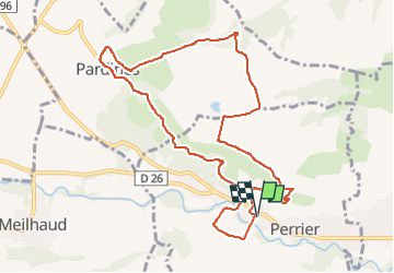
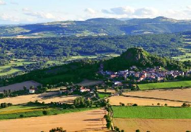
Tour Wandern von 10,7 km verfügbar auf Auvergne-Rhone-Alpen, Puy-de-Dôme, Perrier. Diese Tour wird von jagarnier vorgeschlagen.
Beschreibung
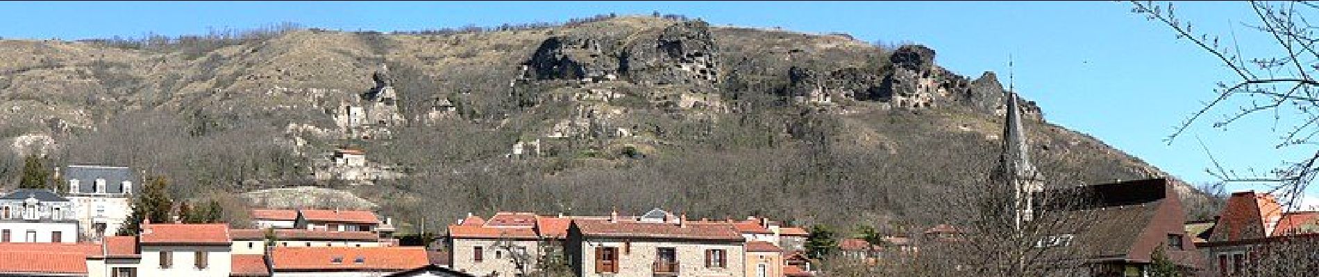
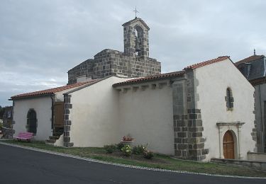
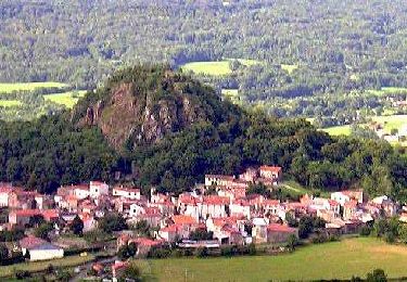
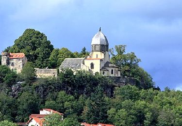
Une histoire géologique complexe marque le plateau où se passe la plus grande partie de la randonnée. L’érosion nous a légué des formes spectaculaires. Des cheminées de fées et des abris troglodytes offert aux premiers occupants de ces lieux. Un des sites les plus spectaculaires du Puy de Dôme.
Ort
Kommentare
Touren in der Umgebung
![Tour Zu Fuß Saint-Vincent - Lavelle - Photo](https://media.geolcdn.com/t/375/260/297b1057-563f-4657-92b7-0e66d7544f1c.jpeg&format=jpg&maxdim=2)
![Zu Fuß Zu Fuß](https://static1.geolcdn.com/sitytour/trail-icons/100.png)
Zu Fuß
![](/images/other/stat-length.png)
![](https://static1.geolcdn.com/siteimages/upload/files/16400158638029165_repeat_loop_refresh_sync_direction_icon.png)
![Tour Zu Fuß Solignat - Le Puy d'Ysson - Photo](https://media.geolcdn.com/t/375/260/f1717d1b-4654-496b-985d-41ee86c18055.jpeg&format=jpg&maxdim=2)
![Zu Fuß Zu Fuß](https://static1.geolcdn.com/sitytour/trail-icons/100.png)
Zu Fuß
![](/images/other/stat-length.png)
![](https://static1.geolcdn.com/siteimages/upload/files/16400158638029165_repeat_loop_refresh_sync_direction_icon.png)
![Tour Zu Fuß Perrier - Chaux de Pardines et Grottes de Perrier - Photo](https://media.geolcdn.com/t/375/260/ab740f7c-222b-48b5-9ed1-765843646dcc.jpeg&format=jpg&maxdim=2)
![Zu Fuß Zu Fuß](https://static1.geolcdn.com/sitytour/trail-icons/100.png)
Zu Fuß
![](/images/other/stat-length.png)
![](https://static1.geolcdn.com/siteimages/upload/files/16400158638029165_repeat_loop_refresh_sync_direction_icon.png)
![Tour Zu Fuß Sauvagnat-Sainte-Marthe - Le Puy Neyrand - Photo](https://media.geolcdn.com/t/375/260/66ff940c-5eaf-4296-b459-bb476a0dff44.jpeg&format=jpg&maxdim=2)
![Zu Fuß Zu Fuß](https://static1.geolcdn.com/sitytour/trail-icons/100.png)
Zu Fuß
![](/images/other/stat-length.png)
![](https://static1.geolcdn.com/siteimages/upload/files/16400158638029165_repeat_loop_refresh_sync_direction_icon.png)
![Tour Wandern Vodable - Vodable_Ronzieres - Photo](https://media.geolcdn.com/t/375/260/212d647d-7980-4e4c-8c90-025466bfa64e.jpg&format=jpg&maxdim=2)
![Wandern Wandern](https://static1.geolcdn.com/sitytour/trail-icons/101.png)
Wandern
![](/images/other/stat-length.png)
![](https://static1.geolcdn.com/siteimages/upload/files/16400158638029165_repeat_loop_refresh_sync_direction_icon.png)
![Tour Wandern Saint-Cirgues-sur-Couze - St_Cirgues_St_Floret_Tourzel - Photo](https://media.geolcdn.com/t/375/260/a7c315fb-38af-4974-a2f4-04a3cbd53b90.jpg&format=jpg&maxdim=2)
![Wandern Wandern](https://static1.geolcdn.com/sitytour/trail-icons/101.png)
Wandern
![](/images/other/stat-length.png)
![](https://static1.geolcdn.com/siteimages/upload/files/16400158638029165_repeat_loop_refresh_sync_direction_icon.png)
![Tour Wandern Solignat - Solignat_Tremoux - Photo](https://media.geolcdn.com/t/375/260/e856ae65-1de9-41d0-84c0-00388d4a3693.jpg&format=jpg&maxdim=2)
![Wandern Wandern](https://static1.geolcdn.com/sitytour/trail-icons/101.png)
Wandern
![](/images/other/stat-length.png)
![](https://static1.geolcdn.com/siteimages/upload/files/16400158638029165_repeat_loop_refresh_sync_direction_icon.png)
![Tour Wandern Solignat - PUY D'YSSON - Photo](https://media.geolcdn.com/t/375/260/3b7e0b3f-724f-4d06-b6ea-37f97bcd46b2.jpg&format=jpg&maxdim=2)
![Wandern Wandern](https://static1.geolcdn.com/sitytour/trail-icons/101.png)
Wandern
![](/images/other/stat-length.png)
![](https://static1.geolcdn.com/siteimages/upload/files/16400158638029165_repeat_loop_refresh_sync_direction_icon.png)
![Tour Wandern Chidrac - Chidrac à Saint-Floret - Photo](https://media.geolcdn.com/t/375/260/5da59d21-f425-4820-a1ae-0382394f7a2f.jpg&format=jpg&maxdim=2)
![Wandern Wandern](https://static1.geolcdn.com/sitytour/trail-icons/101.png)
Wandern
![](/images/other/stat-length.png)
![](https://static1.geolcdn.com/siteimages/upload/files/16400158638029165_repeat_loop_refresh_sync_direction_icon.png)