![](/images/other/stat-length.png)
![Tour Wandern Saint-Martin-d'Ardèche - Sauze Ardeche AR Gorges - Photo](https://media.geolcdn.com/t/1900/400/ext.pjpeg?maxdim=2&url=https%3A%2F%2Fservices.sitytrail.com%2FGeolivesWS%2FDownloadMedia.ashx%3FTrailID%3D633350%26Media%3Dfix__20160919121717.jpg)
Sauze Ardeche AR Gorges
kephas
Benutzer
![Länge](/images/other/stat-length.png)
Länge
12,4 km
![Maximale Höhe](https://static1.geolcdn.com/siteimages/upload/files/1508320355ic_sort_altitude_max_24dp.png)
Maximale Höhe
167 m
![Positive Höhendifferenz](https://static1.geolcdn.com/siteimages/upload/files/1508320355ic_sort_den_pos_24dp.png)
Positive Höhendifferenz
531 m
![Km-Effort](/images/other/stat-length.png)
Km-Effort
19,5 km
![Min. Höhe](https://static1.geolcdn.com/siteimages/upload/files/1508320355ic_sort_altitude_min_24dp.png)
Min. Höhe
48 m
![Negative Höhendifferenz](https://static1.geolcdn.com/siteimages/upload/files/1508320355ic_sort_den_neg_24dp.png)
Negative Höhendifferenz
531 m
![Boucle](https://static1.geolcdn.com/siteimages/upload/files/16400158638029165_repeat_loop_refresh_sync_direction_icon.png)
Boucle
Ja
Erstellungsdatum :
2016-09-19 00:00:00.0
Letzte Änderung :
2016-09-19 00:00:00.0
![Wandern](https://static1.geolcdn.com/sitytour/trail-icons/101.png)
4h05
Schwierigkeit : Medium
![Scannen Sie diesen QR-Code, um die Tour in der SityTrail-Anwendung zu öffnen](https://capi.geolives.com/qq0zvz2zws4bq2lad0pu/sitytour/trails/633350/qr.png?size=200)
Kostenlosegpshiking-Anwendung
Über SityTrail
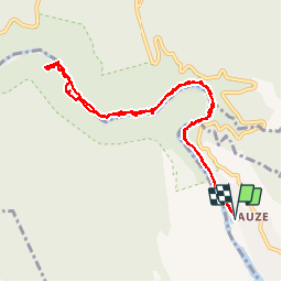
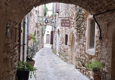
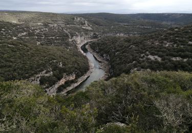
Tour Wandern von 12,4 km verfügbar auf Auvergne-Rhone-Alpen, Ardèche, Saint-Martin-d'Ardèche. Diese Tour wird von kephas vorgeschlagen.
Beschreibung
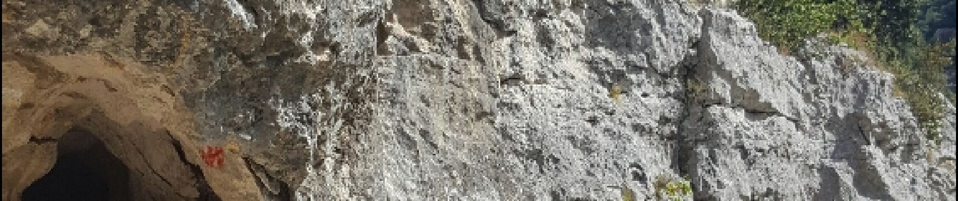
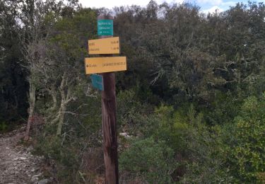
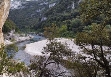
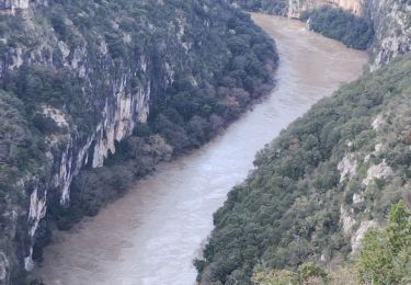
Aller et retour dans les gorges de L'Ardèche.
Des passages aménagés avec échelles.
Ne pas effectuer les jours de pluie, roches glissantes
Ort
Land:
France
Region :
Auvergne-Rhone-Alpen
Abteilung/Provinz :
Ardèche
Kommune :
Saint-Martin-d'Ardèche
Standort:
Unknown
Gehen Sie:(Dec)
Gehen Sie:(UTM)
623869 ; 4907656 (31T) N.
Kommentare
Touren in der Umgebung
![Tour Wandern Saint-Martin-d'Ardèche - GR4 Aigueze - Photo](https://media.geolcdn.com/t/375/260/ext.jpg?maxdim=2&url=https%3A%2F%2Fservices.sitytrail.com%2FGeolivesWS%2FDownloadMedia.ashx%3FTrailID%3D325544%26Media%3Dfix__20140709163308.jpg)
![Wandern Wandern](https://static1.geolcdn.com/sitytour/trail-icons/101.png)
GR4 Aigueze
Wandern
Medium
(1)
Saint-Martin-d'Ardèche,
Auvergne-Rhone-Alpen,
Ardèche,
France
![](/images/other/stat-length.png)
12,6 km | 17 km-effort
4h 39min
![](https://static1.geolcdn.com/siteimages/upload/files/16400158638029165_repeat_loop_refresh_sync_direction_icon.png)
Ja
![Tour Wandern Aiguèze - 30 aigueze ribeirol - Photo](https://media.geolcdn.com/t/375/260/a5de248d-2217-49e5-9c57-d3e37cd5f6c4.jpg&format=jpg&maxdim=2)
![Wandern Wandern](https://static1.geolcdn.com/sitytour/trail-icons/101.png)
30 aigueze ribeirol
Wandern
Schwierig
Aiguèze,
Okzitanien,
Gard,
France
![](/images/other/stat-length.png)
10,7 km | 16,4 km-effort
6h 26min
![](https://static1.geolcdn.com/siteimages/upload/files/16400158638029165_repeat_loop_refresh_sync_direction_icon.png)
Ja
![Tour Wandern Saint-Martin-d'Ardèche - Aigueze rocher de Castelviel - Photo](https://media.geolcdn.com/t/375/260/416d7ebd-2359-4463-8249-a90d2272e98d.jpg&format=jpg&maxdim=2)
![Wandern Wandern](https://static1.geolcdn.com/sitytour/trail-icons/101.png)
Aigueze rocher de Castelviel
Wandern
Einfach
Saint-Martin-d'Ardèche,
Auvergne-Rhone-Alpen,
Ardèche,
France
![](/images/other/stat-length.png)
12,5 km | 16,8 km-effort
4h 11min
![](https://static1.geolcdn.com/siteimages/upload/files/16400158638029165_repeat_loop_refresh_sync_direction_icon.png)
Ja
![Tour Wandern Saint-Martin-d'Ardèche - Sauze bivouac de Gournier - Photo](https://media.geolcdn.com/t/375/260/baac8ebe-8937-4db4-b6c4-7e0bd115b9f1.jpg&format=jpg&maxdim=2)
![Wandern Wandern](https://static1.geolcdn.com/sitytour/trail-icons/101.png)
Sauze bivouac de Gournier
Wandern
Medium
Saint-Martin-d'Ardèche,
Auvergne-Rhone-Alpen,
Ardèche,
France
![](/images/other/stat-length.png)
14,9 km | 25 km-effort
4h 3min
![](https://static1.geolcdn.com/siteimages/upload/files/16400158638029165_repeat_loop_refresh_sync_direction_icon.png)
Nein
![Tour Wandern Saint-Martin-d'Ardèche - 07 st martin d ardeche gorge ardeche - Photo](https://media.geolcdn.com/t/375/260/fdc113c1-1a01-412d-be10-a6b4f2c87d8a.jpg&format=jpg&maxdim=2)
![Wandern Wandern](https://static1.geolcdn.com/sitytour/trail-icons/101.png)
07 st martin d ardeche gorge ardeche
Wandern
Medium
Saint-Martin-d'Ardèche,
Auvergne-Rhone-Alpen,
Ardèche,
France
![](/images/other/stat-length.png)
17,2 km | 25 km-effort
6h 36min
![](https://static1.geolcdn.com/siteimages/upload/files/16400158638029165_repeat_loop_refresh_sync_direction_icon.png)
Ja
![Tour Wandern Aiguèze - Aigueze - Photo](https://media.geolcdn.com/t/375/260/e7b8de9a-d915-48ca-baac-0319f593dc54.jpg&format=jpg&maxdim=2)
![Wandern Wandern](https://static1.geolcdn.com/sitytour/trail-icons/101.png)
![Tour Wandern Saint-Martin-d'Ardèche - Saint Martin d’Ardéche - Photo](https://media.geolcdn.com/t/375/260/b543bd48-15f1-4b47-a933-7d4f79f7128e.jpg&format=jpg&maxdim=2)
![Wandern Wandern](https://static1.geolcdn.com/sitytour/trail-icons/101.png)
Saint Martin d’Ardéche
Wandern
Schwierig
Saint-Martin-d'Ardèche,
Auvergne-Rhone-Alpen,
Ardèche,
France
![](/images/other/stat-length.png)
12,6 km | 16,8 km-effort
5h 3min
![](https://static1.geolcdn.com/siteimages/upload/files/16400158638029165_repeat_loop_refresh_sync_direction_icon.png)
Nein
![Tour Zu Fuß Aiguèze - FR-PR 24 - Photo](https://media.geolcdn.com/t/375/260/adb231a8-9d03-4c90-9261-a3c9f3c8fd1c.jpeg&format=jpg&maxdim=2)
![Zu Fuß Zu Fuß](https://static1.geolcdn.com/sitytour/trail-icons/100.png)
![Tour Wandern Aiguèze - aigueze - Photo](https://media.geolcdn.com/t/375/260/9a8e66bd-28b9-4786-9840-dbf6e6fca8cf.jpg&format=jpg&maxdim=2)
![Wandern Wandern](https://static1.geolcdn.com/sitytour/trail-icons/101.png)
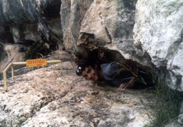
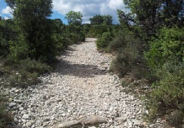
Parcours difficile pour sportif confirmé. Ne pas faire seul en cas de canicule.