![](/images/other/stat-length.png)
![Tour Wandern Voujeaucourt - Soup'Rando 2016 7,6 Km - Photo](https://media.geolcdn.com/t/1900/400/ext.pjpeg?maxdim=2&url=https%3A%2F%2Fstatic1.geolcdn.com%2Fsiteimages%2Fupload%2Ffiles%2F1553511878bg_sport_marche.png)
Soup'Rando 2016 7,6 Km
Guytoumo
Benutzer
![Länge](/images/other/stat-length.png)
![Maximale Höhe](https://static1.geolcdn.com/siteimages/upload/files/1508320355ic_sort_altitude_max_24dp.png)
![Positive Höhendifferenz](https://static1.geolcdn.com/siteimages/upload/files/1508320355ic_sort_den_pos_24dp.png)
![Km-Effort](/images/other/stat-length.png)
![Min. Höhe](https://static1.geolcdn.com/siteimages/upload/files/1508320355ic_sort_altitude_min_24dp.png)
![Negative Höhendifferenz](https://static1.geolcdn.com/siteimages/upload/files/1508320355ic_sort_den_neg_24dp.png)
![Boucle](https://static1.geolcdn.com/siteimages/upload/files/16400158638029165_repeat_loop_refresh_sync_direction_icon.png)
![Wandern](https://static1.geolcdn.com/sitytour/trail-icons/101.png)
2h00
Schwierigkeit : Einfach
![Scannen Sie diesen QR-Code, um die Tour in der SityTrail-Anwendung zu öffnen](https://capi.geolives.com/qq0zvz2zws4bq2lad0pu/sitytour/trails/631328/qr.png?size=200)
Kostenlosegpshiking-Anwendung
Über SityTrail
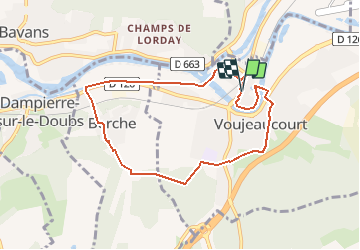
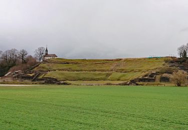
Tour Wandern von 7,6 km verfügbar auf Burgund und Freigrafschaft, Doubs, Voujeaucourt. Diese Tour wird von Guytoumo vorgeschlagen.
Beschreibung
En sortant de la salle des fêtes, traverser la rue et tourner à droite. Après le passage à niveau, descendre l’escalier sur la gauche, traverser le quartier du Maroc et suivre le canal vers la gauche. Après la pause de Berche, tourner à gauche au bout du chemin qui passe derrière les maisons. Retour par le bois des Chevalières, la rue de la Coudraie pour un apéritif puis la salle des fêtes pour le repas.
Ort
Kommentare
Touren in der Umgebung
![Tour Wandern Dung - dung - Photo](https://media.geolcdn.com/t/375/260/a8063218-9e26-446b-a7f7-120eee643097.jpg&format=jpg&maxdim=2)
![Wandern Wandern](https://static1.geolcdn.com/sitytour/trail-icons/101.png)
Wandern
![](/images/other/stat-length.png)
![](https://static1.geolcdn.com/siteimages/upload/files/16400158638029165_repeat_loop_refresh_sync_direction_icon.png)
![Tour Andere Aktivitäten Voujeaucourt - de voujeaucourt à Dambelin, puis pont de roide - Photo](https://media.geolcdn.com/t/375/260/ext.jpg?maxdim=2&url=https%3A%2F%2Fservices.sitytrail.com%2FGeolivesWS%2FDownloadMedia.ashx%3FTrailID%3D737146%26Media%3Dfix__20170421173351.jpg)
![Andere Aktivitäten Andere Aktivitäten](https://static1.geolcdn.com/sitytour/trail-icons/900.png)
Andere Aktivitäten
![](/images/other/stat-length.png)
![](https://static1.geolcdn.com/siteimages/upload/files/16400158638029165_repeat_loop_refresh_sync_direction_icon.png)
![Tour Nordic Walking Courcelles-lès-Montbéliard - randonnée du lion 2024 - Photo](https://media.geolcdn.com/t/375/260/3f9f281c-6be4-4486-9d0b-09b5ebf8048a.jpg&format=jpg&maxdim=2)
![Nordic Walking Nordic Walking](https://static1.geolcdn.com/sitytour/trail-icons/102.png)
Nordic Walking
![](/images/other/stat-length.png)
![](https://static1.geolcdn.com/siteimages/upload/files/16400158638029165_repeat_loop_refresh_sync_direction_icon.png)
![Tour sport Montbéliard - Marche de Noël - Photo](https://media.geolcdn.com/t/375/260/7aaf9d1e-59c1-4398-92df-e6e19d5ef6bb.jpg&format=jpg&maxdim=2)
sport
![](/images/other/stat-length.png)
![](https://static1.geolcdn.com/siteimages/upload/files/16400158638029165_repeat_loop_refresh_sync_direction_icon.png)
![Tour Mountainbike Montbéliard - rando VTT club de montbeliard - Photo](https://media.geolcdn.com/t/375/260/dc7d4ac0-476c-43ee-8bbf-18ea53e044c3.jpg&format=jpg&maxdim=2)
![Mountainbike Mountainbike](https://static1.geolcdn.com/sitytour/trail-icons/202.png)
Mountainbike
![](/images/other/stat-length.png)
![](https://static1.geolcdn.com/siteimages/upload/files/16400158638029165_repeat_loop_refresh_sync_direction_icon.png)
![Tour Wandern Montbéliard - zz - Photo](https://media.geolcdn.com/t/375/260/2d06c4ab-787f-49e0-aee3-05473fb86371.jpg&format=jpg&maxdim=2)
![Wandern Wandern](https://static1.geolcdn.com/sitytour/trail-icons/101.png)
Wandern
![](/images/other/stat-length.png)
![](https://static1.geolcdn.com/siteimages/upload/files/16400158638029165_repeat_loop_refresh_sync_direction_icon.png)
![Tour Radtourismus Arbouans - GTJ #1 - Photo](https://media.geolcdn.com/t/375/260/bc869aa9-9c52-4e94-806e-b0926b148033.jpg&format=jpg&maxdim=2)
![Radtourismus Radtourismus](https://static1.geolcdn.com/sitytour/trail-icons/204.png)
Radtourismus
![](/images/other/stat-length.png)
![](https://static1.geolcdn.com/siteimages/upload/files/16400158638029165_repeat_loop_refresh_sync_direction_icon.png)
![Tour Wandern Mandeure - Mandeure 1 - Photo](https://media.geolcdn.com/t/375/260/074bd74f-4d1e-4ebb-b363-d85a06bb441a.jpg&format=jpg&maxdim=2)
![Wandern Wandern](https://static1.geolcdn.com/sitytour/trail-icons/101.png)
Wandern
![](/images/other/stat-length.png)
![](https://static1.geolcdn.com/siteimages/upload/files/16400158638029165_repeat_loop_refresh_sync_direction_icon.png)
![Tour Wandern Mandeure - Etape 1 GTJ : Mandeure à Pont de Roide - Photo](https://media.geolcdn.com/t/375/260/b9c884aa-6364-4edd-9de9-19d71f8c4dd8.jpg&format=jpg&maxdim=2)
![Wandern Wandern](https://static1.geolcdn.com/sitytour/trail-icons/101.png)
Wandern
![](/images/other/stat-length.png)
![](https://static1.geolcdn.com/siteimages/upload/files/16400158638029165_repeat_loop_refresh_sync_direction_icon.png)