![](/images/other/stat-length.png)
![Tour Laufen Annecy - Annecy - Chambéry - Photo](https://media.geolcdn.com/t/1900/400/ext.pjpeg?maxdim=2&url=https%3A%2F%2Fstatic1.geolcdn.com%2Fsiteimages%2Fupload%2Ffiles%2F1524743154running.jpg)
Annecy - Chambéry
loairline
Benutzer
![Länge](/images/other/stat-length.png)
Länge
67 km
![Maximale Höhe](https://static1.geolcdn.com/siteimages/upload/files/1508320355ic_sort_altitude_max_24dp.png)
Maximale Höhe
1692 m
![Positive Höhendifferenz](https://static1.geolcdn.com/siteimages/upload/files/1508320355ic_sort_den_pos_24dp.png)
Positive Höhendifferenz
3153 m
![Km-Effort](/images/other/stat-length.png)
Km-Effort
109 km
![Min. Höhe](https://static1.geolcdn.com/siteimages/upload/files/1508320355ic_sort_altitude_min_24dp.png)
Min. Höhe
400 m
![Negative Höhendifferenz](https://static1.geolcdn.com/siteimages/upload/files/1508320355ic_sort_den_neg_24dp.png)
Negative Höhendifferenz
3201 m
![Boucle](https://static1.geolcdn.com/siteimages/upload/files/16400158638029165_repeat_loop_refresh_sync_direction_icon.png)
Boucle
Nein
Erstellungsdatum :
1970-01-01 00:01:00.0
Letzte Änderung :
2020-06-26 20:01:45.567
![Laufen](https://static1.geolcdn.com/sitytour/trail-icons/103.png)
6h00
Schwierigkeit : Schwierig
![Scannen Sie diesen QR-Code, um die Tour in der SityTrail-Anwendung zu öffnen](https://capi.geolives.com/qq0zvz2zws4bq2lad0pu/sitytour/trails/628992/qr.png?size=200)
Kostenlosegpshiking-Anwendung
Über SityTrail
Tour Laufen von 67 km verfügbar auf Auvergne-Rhone-Alpen, Hochsavoyen, Annecy. Diese Tour wird von loairline vorgeschlagen.
Beschreibung
Départ d'Annecy le vieux. Montée par le Semnoz, montagne de Banges, Saint François de Sales, Revard et Le nivolet...
Ort
Land:
France
Region :
Auvergne-Rhone-Alpen
Abteilung/Provinz :
Hochsavoyen
Kommune :
Annecy
Standort:
Annecy-le-Vieux
Gehen Sie:(Dec)
Gehen Sie:(UTM)
278384 ; 5088448 (32T) N.
Kommentare
Touren in der Umgebung
![Tour Wandern Veyrier-du-Lac - 74 Mt Veyrier 26.06.23 - Photo](https://media.geolcdn.com/t/375/260/e7069dc2-0437-4294-a5ae-f7942e994b91.jpg&format=jpg&maxdim=2)
![Wandern Wandern](https://static1.geolcdn.com/sitytour/trail-icons/101.png)
74 Mt Veyrier 26.06.23
Wandern
Medium
Veyrier-du-Lac,
Auvergne-Rhone-Alpen,
Hochsavoyen,
France
![](/images/other/stat-length.png)
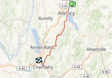
8,1 km | 18,5 km-effort
4h 19min
![](https://static1.geolcdn.com/siteimages/upload/files/16400158638029165_repeat_loop_refresh_sync_direction_icon.png)
Ja
![Tour Fahrrad Annecy - semnoz par quintal - Photo](https://media.geolcdn.com/t/375/260/ext.jpg?maxdim=2&url=https%3A%2F%2Fstatic1.geolcdn.com%2Fsiteimages%2Fupload%2Ffiles%2F1524743154velo.jpg)
![Fahrrad Fahrrad](https://static1.geolcdn.com/sitytour/trail-icons/200.png)
semnoz par quintal
Fahrrad
Medium
(1)
Annecy,
Auvergne-Rhone-Alpen,
Hochsavoyen,
France
![](/images/other/stat-length.png)
32 km | 52 km-effort
11min
![](https://static1.geolcdn.com/siteimages/upload/files/16400158638029165_repeat_loop_refresh_sync_direction_icon.png)
Nein
![Tour Mountainbike Annecy - semnoz 31 8 10 - Photo](https://media.geolcdn.com/t/375/260/ext.jpg?maxdim=2&url=https%3A%2F%2Fstatic1.geolcdn.com%2Fsiteimages%2Fupload%2Ffiles%2F1524743154velo.jpg)
![Mountainbike Mountainbike](https://static1.geolcdn.com/sitytour/trail-icons/202.png)
semnoz 31 8 10
Mountainbike
Sehr leicht
(1)
Annecy,
Auvergne-Rhone-Alpen,
Hochsavoyen,
France
![](/images/other/stat-length.png)
31 km | 48 km-effort
Unbekannt
![](https://static1.geolcdn.com/siteimages/upload/files/16400158638029165_repeat_loop_refresh_sync_direction_icon.png)
Ja
![Tour Hybrid-Bike Annecy - ANNECY ... le Tour du lac à vélo. - Photo](https://media.geolcdn.com/t/375/260/64c38e9e-432d-4f1e-a098-d3a526529324.jpg&format=jpg&maxdim=2)
![Hybrid-Bike Hybrid-Bike](https://static1.geolcdn.com/sitytour/trail-icons/203.png)
ANNECY ... le Tour du lac à vélo.
Hybrid-Bike
Einfach
Annecy,
Auvergne-Rhone-Alpen,
Hochsavoyen,
France
![](/images/other/stat-length.png)
38 km | 44 km-effort
1h 55min
![](https://static1.geolcdn.com/siteimages/upload/files/16400158638029165_repeat_loop_refresh_sync_direction_icon.png)
Ja
![Tour Wandern Annecy - ANNECY ... le sentier des crêtes. - Photo](https://media.geolcdn.com/t/375/260/954e85ce-e790-4ec1-8a5b-52762288e410.jpg&format=jpg&maxdim=2)
![Wandern Wandern](https://static1.geolcdn.com/sitytour/trail-icons/101.png)
ANNECY ... le sentier des crêtes.
Wandern
Schwierig
Annecy,
Auvergne-Rhone-Alpen,
Hochsavoyen,
France
![](/images/other/stat-length.png)
10,6 km | 16,2 km-effort
3h 21min
![](https://static1.geolcdn.com/siteimages/upload/files/16400158638029165_repeat_loop_refresh_sync_direction_icon.png)
Ja
![Tour Wandern Annecy - 260523 Monr Veyrier - Photo](https://media.geolcdn.com/t/375/260/7cafe482-fdd0-430f-9583-efd1a36c0573.jpg&format=jpg&maxdim=2)
![Wandern Wandern](https://static1.geolcdn.com/sitytour/trail-icons/101.png)
260523 Monr Veyrier
Wandern
Schwierig
Annecy,
Auvergne-Rhone-Alpen,
Hochsavoyen,
France
![](/images/other/stat-length.png)
12,6 km | 25 km-effort
4h 24min
![](https://static1.geolcdn.com/siteimages/upload/files/16400158638029165_repeat_loop_refresh_sync_direction_icon.png)
Ja
![Tour Wandern Annecy - course avec tobias - Photo](https://media.geolcdn.com/t/375/260/5511a080-8bbf-4e35-a1e7-eb6c019b0144.jpg&format=jpg&maxdim=2)
![Wandern Wandern](https://static1.geolcdn.com/sitytour/trail-icons/101.png)
course avec tobias
Wandern
Medium
Annecy,
Auvergne-Rhone-Alpen,
Hochsavoyen,
France
![](/images/other/stat-length.png)
9,9 km | 13,7 km-effort
1h 40min
![](https://static1.geolcdn.com/siteimages/upload/files/16400158638029165_repeat_loop_refresh_sync_direction_icon.png)
Ja
![Tour Radtourismus Veyrier-du-Lac - tour du lac d annecy - Photo](https://media.geolcdn.com/t/375/260/c737b45c-84b1-41e1-b4e0-10680cc8a9ed.jpg&format=jpg&maxdim=2)
![Radtourismus Radtourismus](https://static1.geolcdn.com/sitytour/trail-icons/204.png)
tour du lac d annecy
Radtourismus
Sehr schwierig
Veyrier-du-Lac,
Auvergne-Rhone-Alpen,
Hochsavoyen,
France
![](/images/other/stat-length.png)
39 km | 45 km-effort
2h 57min
![](https://static1.geolcdn.com/siteimages/upload/files/16400158638029165_repeat_loop_refresh_sync_direction_icon.png)
Ja
![Tour Wandern Veyrier-du-Lac - Mont Baret - Photo](https://media.geolcdn.com/t/375/260/204f4d77-91e4-44cb-b334-ef87d103e733.jpg&format=jpg&maxdim=2)
![Wandern Wandern](https://static1.geolcdn.com/sitytour/trail-icons/101.png)
Mont Baret
Wandern
Sehr leicht
Veyrier-du-Lac,
Auvergne-Rhone-Alpen,
Hochsavoyen,
France
![](/images/other/stat-length.png)
10,4 km | 22 km-effort
3h 28min
![](https://static1.geolcdn.com/siteimages/upload/files/16400158638029165_repeat_loop_refresh_sync_direction_icon.png)
Nein