![](/images/other/stat-length.png)
![Tour Wandern Vallorcine - CHAMONIX (Cascade de Bérard) - Photo](https://media.geolcdn.com/t/1900/400/ext.pjpeg?maxdim=2&url=https%3A%2F%2Fservices.sitytrail.com%2FGeolivesWS%2FDownloadMedia.ashx%3FTrailID%3D627009%26Media%3Dfix__20160906101203.jpg)
CHAMONIX (Cascade de Bérard)
GerardBouche
Benutzer
![Länge](/images/other/stat-length.png)
Länge
9,2 km
![Maximale Höhe](https://static1.geolcdn.com/siteimages/upload/files/1508320355ic_sort_altitude_max_24dp.png)
Maximale Höhe
1707 m
![Positive Höhendifferenz](https://static1.geolcdn.com/siteimages/upload/files/1508320355ic_sort_den_pos_24dp.png)
Positive Höhendifferenz
439 m
![Km-Effort](/images/other/stat-length.png)
Km-Effort
15,1 km
![Min. Höhe](https://static1.geolcdn.com/siteimages/upload/files/1508320355ic_sort_altitude_min_24dp.png)
Min. Höhe
1328 m
![Negative Höhendifferenz](https://static1.geolcdn.com/siteimages/upload/files/1508320355ic_sort_den_neg_24dp.png)
Negative Höhendifferenz
441 m
![Boucle](https://static1.geolcdn.com/siteimages/upload/files/16400158638029165_repeat_loop_refresh_sync_direction_icon.png)
Boucle
Ja
Erstellungsdatum :
2017-07-15 00:00:00.0
Letzte Änderung :
2017-07-15 00:00:00.0
![Wandern](https://static1.geolcdn.com/sitytour/trail-icons/101.png)
3h17
Schwierigkeit : Einfach
![Scannen Sie diesen QR-Code, um die Tour in der SityTrail-Anwendung zu öffnen](https://capi.geolives.com/qq0zvz2zws4bq2lad0pu/sitytour/trails/627009/qr.png?size=200)
Kostenlosegpshiking-Anwendung
Über SityTrail
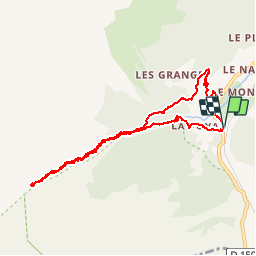
Tour Wandern von 9,2 km verfügbar auf Auvergne-Rhone-Alpen, Hochsavoyen, Vallorcine. Diese Tour wird von GerardBouche vorgeschlagen.
Beschreibung
Superbe parcours au départ de "Le BUET" (commune de Vallorcine) vers la cascade de Bérard et la réserve naturelle classée en 1992 en direction du refuge de la "Pierre à Bérard". Le retour par les alpages "Sur le Rocher".
Ort
Land:
France
Region :
Auvergne-Rhone-Alpen
Abteilung/Provinz :
Hochsavoyen
Kommune :
Vallorcine
Standort:
Unknown
Gehen Sie:(Dec)
Gehen Sie:(UTM)
338983 ; 5098259 (32T) N.
Kommentare
Touren in der Umgebung
![Tour Wandern Vallorcine - Le Buet - Vallorcine - Photo](https://media.geolcdn.com/t/375/260/ext.jpg?maxdim=2&url=https%3A%2F%2Fservices.sitytrail.com%2FGeolivesWS%2FDownloadMedia.ashx%3FTrailID%3D105027%26Media%3D8587_6.jpg)
![Wandern Wandern](https://static1.geolcdn.com/sitytour/trail-icons/101.png)
Le Buet - Vallorcine
Wandern
Schwierig
(1)
Vallorcine,
Auvergne-Rhone-Alpen,
Hochsavoyen,
France
![](/images/other/stat-length.png)
9 km | 27 km-effort
7h 0min
![](https://static1.geolcdn.com/siteimages/upload/files/16400158638029165_repeat_loop_refresh_sync_direction_icon.png)
Nein
![Tour Wintersport Vallorcine - vers Finhaut - Photo](https://media.geolcdn.com/t/375/260/ext.jpg?maxdim=2&url=https%3A%2F%2Fstatic1.geolcdn.com%2Fsiteimages%2Fupload%2Ffiles%2F1524743153ski.jpg)
![Wintersport Wintersport](https://static1.geolcdn.com/sitytour/trail-icons/500.png)
vers Finhaut
Wintersport
Medium
(1)
Vallorcine,
Auvergne-Rhone-Alpen,
Hochsavoyen,
France
![](/images/other/stat-length.png)
22 km | 40 km-effort
5h 0min
![](https://static1.geolcdn.com/siteimages/upload/files/16400158638029165_repeat_loop_refresh_sync_direction_icon.png)
Nein
![Tour Wandern Chamonix-Mont-Blanc - Randonnée dans la Vallée de Chamonix - Photo](https://media.geolcdn.com/t/375/260/ext.jpg?maxdim=2&url=https%3A%2F%2Fmedia.geolcdn.com%2Ff%2F1572227c-7039-4906-9929-df662ca33afb.jpg)
![Wandern Wandern](https://static1.geolcdn.com/sitytour/trail-icons/101.png)
Randonnée dans la Vallée de Chamonix
Wandern
Einfach
Chamonix-Mont-Blanc,
Auvergne-Rhone-Alpen,
Hochsavoyen,
France
![](/images/other/stat-length.png)
12,5 km | 15,3 km-effort
3h 13min
![](https://static1.geolcdn.com/siteimages/upload/files/16400158638029165_repeat_loop_refresh_sync_direction_icon.png)
Nein
![Tour Wandern Chamonix-Mont-Blanc - Les aiguilles Rouges Chamonix Argentière - Photo](https://media.geolcdn.com/t/375/260/ext.jpg?maxdim=2&url=https%3A%2F%2Fmedia.geolcdn.com%2Ff%2F589f3ac8-c8ad-4a69-8860-8b1a7ead14c1.jpg)
![Wandern Wandern](https://static1.geolcdn.com/sitytour/trail-icons/101.png)
Les aiguilles Rouges Chamonix Argentière
Wandern
Schwierig
Chamonix-Mont-Blanc,
Auvergne-Rhone-Alpen,
Hochsavoyen,
France
![](/images/other/stat-length.png)
11,9 km | 25 km-effort
7h 32min
![](https://static1.geolcdn.com/siteimages/upload/files/16400158638029165_repeat_loop_refresh_sync_direction_icon.png)
Ja
![Tour Wandern Vallorcine - Vallorcine - Fontaine Froide - Sur le Rocher - Côte du Nant - Photo](https://media.geolcdn.com/t/375/260/ext.jpg?maxdim=2&url=https%3A%2F%2Fmedia.geolcdn.com%2Ff%2F373ba6dc-2c4b-4475-84a1-433c7fa12019.JPG)
![Wandern Wandern](https://static1.geolcdn.com/sitytour/trail-icons/101.png)
Vallorcine - Fontaine Froide - Sur le Rocher - Côte du Nant
Wandern
Medium
Vallorcine,
Auvergne-Rhone-Alpen,
Hochsavoyen,
France
![](/images/other/stat-length.png)
6,3 km | 10,3 km-effort
2h 19min
![](https://static1.geolcdn.com/siteimages/upload/files/16400158638029165_repeat_loop_refresh_sync_direction_icon.png)
Ja
![Tour Wandern Chamonix-Mont-Blanc - TMB8 CAF 24 - Photo](https://media.geolcdn.com/t/375/260/ext.jpg?maxdim=2&url=https%3A%2F%2Fmedia.geolcdn.com%2Ff%2Fc9419578-055e-4af5-b5b9-3415cdc2c84a.jpg)
![Wandern Wandern](https://static1.geolcdn.com/sitytour/trail-icons/101.png)
TMB8 CAF 24
Wandern
Sehr schwierig
Chamonix-Mont-Blanc,
Auvergne-Rhone-Alpen,
Hochsavoyen,
France
![](/images/other/stat-length.png)
17,5 km | 33 km-effort
7h 33min
![](https://static1.geolcdn.com/siteimages/upload/files/16400158638029165_repeat_loop_refresh_sync_direction_icon.png)
Nein
![Tour Wandern Chamonix-Mont-Blanc - Argentieres(aire de jeu) - Photo](https://media.geolcdn.com/t/375/260/ext.jpg?maxdim=2&url=https%3A%2F%2Fmedia.geolcdn.com%2Ff%2F1704b36a-5e9a-47fa-bf8b-1f747cb1be14.jpg)
![Wandern Wandern](https://static1.geolcdn.com/sitytour/trail-icons/101.png)
Argentieres(aire de jeu)
Wandern
Einfach
Chamonix-Mont-Blanc,
Auvergne-Rhone-Alpen,
Hochsavoyen,
France
![](/images/other/stat-length.png)
9,4 km | 18,1 km-effort
2h 54min
![](https://static1.geolcdn.com/siteimages/upload/files/16400158638029165_repeat_loop_refresh_sync_direction_icon.png)
Nein
![Tour Wandern Vallorcine - téléphérique Vallorcine,col de Balme,aiguillettes des Posettes Montroc - Photo](https://media.geolcdn.com/t/375/260/ext.jpg?maxdim=2&url=https%3A%2F%2Fmedia.geolcdn.com%2Ff%2F34060c99-f20f-4c26-93e7-06e0c904c0b9.jpg)
![Wandern Wandern](https://static1.geolcdn.com/sitytour/trail-icons/101.png)
téléphérique Vallorcine,col de Balme,aiguillettes des Posettes Montroc
Wandern
Einfach
Vallorcine,
Auvergne-Rhone-Alpen,
Hochsavoyen,
France
![](/images/other/stat-length.png)
11,2 km | 19,4 km-effort
3h 28min
![](https://static1.geolcdn.com/siteimages/upload/files/16400158638029165_repeat_loop_refresh_sync_direction_icon.png)
Nein
![Tour Wandern Chamonix-Mont-Blanc - Aiguillette des Posettes 2201m 6.7.22 - Photo](https://media.geolcdn.com/t/375/260/ext.jpg?maxdim=2&url=https%3A%2F%2Fmedia.geolcdn.com%2Ff%2F920b5cab-549c-4a76-961b-08991dae2f72.jpg)
![Wandern Wandern](https://static1.geolcdn.com/sitytour/trail-icons/101.png)
Aiguillette des Posettes 2201m 6.7.22
Wandern
Einfach
Chamonix-Mont-Blanc,
Auvergne-Rhone-Alpen,
Hochsavoyen,
France
![](/images/other/stat-length.png)
8,4 km | 17,8 km-effort
3h 30min
![](https://static1.geolcdn.com/siteimages/upload/files/16400158638029165_repeat_loop_refresh_sync_direction_icon.png)
Ja