![](/images/other/stat-length.png)
![Tour Nordic Walking Sprimont - Banneux - Photo](https://media.geolcdn.com/t/1900/400/ext.pjpeg?maxdim=2&url=https%3A%2F%2Fstatic1.geolcdn.com%2Fsiteimages%2Fupload%2Ffiles%2F1545311037marcheuse_200dpi.jpg)
Banneux
gcolson
Benutzer
![Länge](/images/other/stat-length.png)
Länge
11,4 km
![Maximale Höhe](https://static1.geolcdn.com/siteimages/upload/files/1508320355ic_sort_altitude_max_24dp.png)
Maximale Höhe
322 m
![Positive Höhendifferenz](https://static1.geolcdn.com/siteimages/upload/files/1508320355ic_sort_den_pos_24dp.png)
Positive Höhendifferenz
281 m
![Km-Effort](/images/other/stat-length.png)
Km-Effort
15,2 km
![Min. Höhe](https://static1.geolcdn.com/siteimages/upload/files/1508320355ic_sort_altitude_min_24dp.png)
Min. Höhe
130 m
![Negative Höhendifferenz](https://static1.geolcdn.com/siteimages/upload/files/1508320355ic_sort_den_neg_24dp.png)
Negative Höhendifferenz
281 m
![Boucle](https://static1.geolcdn.com/siteimages/upload/files/16400158638029165_repeat_loop_refresh_sync_direction_icon.png)
Boucle
Ja
Erstellungsdatum :
2017-04-17 00:00:00.0
Letzte Änderung :
2017-04-17 00:00:00.0
![Nordic Walking](https://static1.geolcdn.com/sitytour/trail-icons/102.png)
6h00
Schwierigkeit : Medium
![Scannen Sie diesen QR-Code, um die Tour in der SityTrail-Anwendung zu öffnen](https://capi.geolives.com/qq0zvz2zws4bq2lad0pu/sitytour/trails/618402/qr.png?size=200)
Kostenlosegpshiking-Anwendung
Über SityTrail
Tour Nordic Walking von 11,4 km verfügbar auf Wallonien, Lüttich, Sprimont. Diese Tour wird von gcolson vorgeschlagen.
Beschreibung
Attention le debut de la balade n'a pas été enregistré
En sortant du parking prendre à droite, traverser la grand route et prendre le chemin à gauche.....
Ort
Land:
Belgium
Region :
Wallonien
Abteilung/Provinz :
Lüttich
Kommune :
Sprimont
Standort:
Louveigné
Gehen Sie:(Dec)
Gehen Sie:(UTM)
694641 ; 5602177 (31U) N.
Kommentare
Touren in der Umgebung
![Tour Wandern Theux - Theux - Natura 2000, des sites qui valent le détour - LG22 - Photo](https://media.geolcdn.com/t/375/260/ext.jpg?maxdim=2&url=https%3A%2F%2Fservices.sitytrail.com%2FGeolivesWS%2FDownloadMedia.ashx%3FTrailID%3D612638%26Media%3D53072597-f13a-4b1e-b213-a2c1df094f1f.JPG)
![Wandern Wandern](https://static1.geolcdn.com/sitytour/trail-icons/101.png)
Theux - Natura 2000, des sites qui valent le détour - LG22
Wandern
Medium
(6)
Theux,
Wallonien,
Lüttich,
Belgium
![](/images/other/stat-length.png)
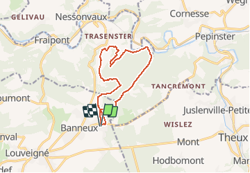
12,7 km | 16,8 km-effort
3h 31min
![](https://static1.geolcdn.com/siteimages/upload/files/16400158638029165_repeat_loop_refresh_sync_direction_icon.png)
Ja
![Tour Wandern Trooz - RB-Lg-03 - Entre Vesdre et Hoëgne - Photo](https://media.geolcdn.com/t/375/260/ext.jpg?maxdim=2&url=https%3A%2F%2Fservices.sitytrail.com%2FGeolivesWS%2FDownloadMedia.ashx%3FTrailID%3D179559%26Media%3Dcef2de81-7d4f-4fcd-9e9d-f315370fe61f.jpg)
![Wandern Wandern](https://static1.geolcdn.com/sitytour/trail-icons/101.png)
RB-Lg-03 - Entre Vesdre et Hoëgne
Wandern
Medium
(12)
Trooz,
Wallonien,
Lüttich,
Belgium
![](/images/other/stat-length.png)
22 km | 29 km-effort
6h 9min
![](https://static1.geolcdn.com/siteimages/upload/files/16400158638029165_repeat_loop_refresh_sync_direction_icon.png)
Ja
![Tour Wandern Sprimont - Banneux - Rouge Thier - Adzeux - Photo](https://media.geolcdn.com/t/375/260/0f185ab2-d29a-4b49-b676-7a8415068951.jpg&format=jpg&maxdim=2)
![Wandern Wandern](https://static1.geolcdn.com/sitytour/trail-icons/101.png)
Banneux - Rouge Thier - Adzeux
Wandern
Einfach
(4)
Sprimont,
Wallonien,
Lüttich,
Belgium
![](/images/other/stat-length.png)
9,1 km | 11,3 km-effort
2h 34min
![](https://static1.geolcdn.com/siteimages/upload/files/16400158638029165_repeat_loop_refresh_sync_direction_icon.png)
Ja
![Tour Wandern Trooz - 2022-02-03_17h57m35_BaladedeFraipont - Photo](https://media.geolcdn.com/t/375/260/a22be754-a7d6-4ac7-b88b-6e30a6735908.jpg&format=jpg&maxdim=2)
![Wandern Wandern](https://static1.geolcdn.com/sitytour/trail-icons/101.png)
2022-02-03_17h57m35_BaladedeFraipont
Wandern
Medium
(1)
Trooz,
Wallonien,
Lüttich,
Belgium
![](/images/other/stat-length.png)
12,3 km | 17,3 km-effort
3h 55min
![](https://static1.geolcdn.com/siteimages/upload/files/16400158638029165_repeat_loop_refresh_sync_direction_icon.png)
Ja
![Tour Wandern Olne - 2021-03-10_16h10m11_1409 - Photo](https://media.geolcdn.com/t/375/260/8c16a020-3972-4fd4-95a4-e68b814bf4ee.jpg&format=jpg&maxdim=2)
![Wandern Wandern](https://static1.geolcdn.com/sitytour/trail-icons/101.png)
2021-03-10_16h10m11_1409
Wandern
Medium
(3)
Olne,
Wallonien,
Lüttich,
Belgium
![](/images/other/stat-length.png)
11,7 km | 16,1 km-effort
3h 39min
![](https://static1.geolcdn.com/siteimages/upload/files/16400158638029165_repeat_loop_refresh_sync_direction_icon.png)
Ja
![Tour Wandern Theux - Theux Natura 2000 château Franchimont - Photo](https://media.geolcdn.com/t/375/260/c750767f-f208-4264-8684-0a202377691f.jpg&format=jpg&maxdim=2)
![Wandern Wandern](https://static1.geolcdn.com/sitytour/trail-icons/101.png)
Theux Natura 2000 château Franchimont
Wandern
Medium
(2)
Theux,
Wallonien,
Lüttich,
Belgium
![](/images/other/stat-length.png)
13,1 km | 17,3 km-effort
3h 0min
![](https://static1.geolcdn.com/siteimages/upload/files/16400158638029165_repeat_loop_refresh_sync_direction_icon.png)
Ja
![Tour Pfad Theux - Extratrail - Theux (blau) 18 km - Photo](https://media.geolcdn.com/t/375/260/0911e17e-920d-442e-8495-16fc909f2c4f.jpg&format=jpg&maxdim=2)
![Pfad Pfad](https://static1.geolcdn.com/sitytour/trail-icons/104.png)
Extratrail - Theux (blau) 18 km
Pfad
Medium
(3)
Theux,
Wallonien,
Lüttich,
Belgium
![](/images/other/stat-length.png)
18,3 km | 25 km-effort
Unbekannt
![](https://static1.geolcdn.com/siteimages/upload/files/16400158638029165_repeat_loop_refresh_sync_direction_icon.png)
Ja
![Tour Wandern Sprimont - banneux . adzeux . grand pierreux . banneux / marche adeps 10 km - Photo](https://media.geolcdn.com/t/375/260/ea0ad600-3155-4a55-9c9f-23c4e38fbcee.jpg&format=jpg&maxdim=2)
![Wandern Wandern](https://static1.geolcdn.com/sitytour/trail-icons/101.png)
banneux . adzeux . grand pierreux . banneux / marche adeps 10 km
Wandern
Einfach
(1)
Sprimont,
Wallonien,
Lüttich,
Belgium
![](/images/other/stat-length.png)
8,6 km | 10,5 km-effort
2h 6min
![](https://static1.geolcdn.com/siteimages/upload/files/16400158638029165_repeat_loop_refresh_sync_direction_icon.png)
Ja
![Tour Wandern Sprimont - les forges . fraipont . andoumont . les forges - Photo](https://media.geolcdn.com/t/375/260/7774fab4-c702-474d-9e3e-f53317a12b64.jpg&format=jpg&maxdim=2)
![Wandern Wandern](https://static1.geolcdn.com/sitytour/trail-icons/101.png)
les forges . fraipont . andoumont . les forges
Wandern
Medium
(3)
Sprimont,
Wallonien,
Lüttich,
Belgium
![](/images/other/stat-length.png)
11,3 km | 15,5 km-effort
3h 7min
![](https://static1.geolcdn.com/siteimages/upload/files/16400158638029165_repeat_loop_refresh_sync_direction_icon.png)
Ja