![](/images/other/stat-length.png)
![Tour Wandern Villeneuve-d'Ascq - Parc du Héron Moulin de Vertain - Photo](https://media.geolcdn.com/t/1900/400/ext.pjpeg?maxdim=2&url=https%3A%2F%2Fstatic1.geolcdn.com%2Fsiteimages%2Fupload%2Ffiles%2F1553511878bg_sport_marche.png)
Parc du Héron Moulin de Vertain
camino59
Benutzer
![Länge](/images/other/stat-length.png)
Länge
22 km
![Maximale Höhe](https://static1.geolcdn.com/siteimages/upload/files/1508320355ic_sort_altitude_max_24dp.png)
Maximale Höhe
39 m
![Positive Höhendifferenz](https://static1.geolcdn.com/siteimages/upload/files/1508320355ic_sort_den_pos_24dp.png)
Positive Höhendifferenz
131 m
![Km-Effort](/images/other/stat-length.png)
Km-Effort
24 km
![Min. Höhe](https://static1.geolcdn.com/siteimages/upload/files/1508320355ic_sort_altitude_min_24dp.png)
Min. Höhe
19 m
![Negative Höhendifferenz](https://static1.geolcdn.com/siteimages/upload/files/1508320355ic_sort_den_neg_24dp.png)
Negative Höhendifferenz
121 m
![Boucle](https://static1.geolcdn.com/siteimages/upload/files/16400158638029165_repeat_loop_refresh_sync_direction_icon.png)
Boucle
Nein
Erstellungsdatum :
2016-08-12 00:00:00.0
Letzte Änderung :
2016-08-12 00:00:00.0
![Wandern](https://static1.geolcdn.com/sitytour/trail-icons/101.png)
5h19
Schwierigkeit : Medium
![Scannen Sie diesen QR-Code, um die Tour in der SityTrail-Anwendung zu öffnen](https://capi.geolives.com/qq0zvz2zws4bq2lad0pu/sitytour/trails/613224/qr.png?size=200)
Kostenlosegpshiking-Anwendung
Über SityTrail
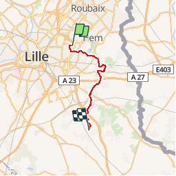
Tour Wandern von 22 km verfügbar auf Nordfrankreich, Nord, Villeneuve-d'Ascq. Diese Tour wird von camino59 vorgeschlagen.
Beschreibung
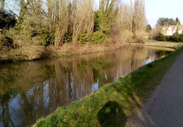
Départ du Campus décatlon à Villeneuve d'Ascq. Rejoindre le parc du Héron et suivre ensuite la Marque qui épouse pour partie le GR 121 B puis vous rendre jusqu'au Moulin de Vertain à Templeuve. Bonne rando
Ort
Land:
France
Region :
Nordfrankreich
Abteilung/Provinz :
Nord
Kommune :
Villeneuve-d'Ascq
Standort:
Unknown
Gehen Sie:(Dec)
Gehen Sie:(UTM)
510152 ; 5610171 (31U) N.
Kommentare
Touren in der Umgebung
![Tour Wandern Tressin - La Gariguette 2014 - Tressin - Photo](https://media.geolcdn.com/t/375/260/ext.jpg?maxdim=2&url=https%3A%2F%2Fservices.sitytrail.com%2FGeolivesWS%2FDownloadMedia.ashx%3FTrailID%3D317914%26Media%3D17331_6.jpg)
![Wandern Wandern](https://static1.geolcdn.com/sitytour/trail-icons/101.png)
La Gariguette 2014 - Tressin
Wandern
Medium
(2)
Tressin,
Nordfrankreich,
Nord,
France
![](/images/other/stat-length.png)
12,9 km | 14 km-effort
3h 15min
![](https://static1.geolcdn.com/siteimages/upload/files/16400158638029165_repeat_loop_refresh_sync_direction_icon.png)
Ja
![Tour Mountainbike Villeneuve-d'Ascq - Le tour des lacs - Villeneuve d'Ascq. - Photo](https://media.geolcdn.com/t/375/260/ext.jpg?maxdim=2&url=https%3A%2F%2Fservices.sitytrail.com%2FGeolivesWS%2FDownloadMedia.ashx%3FTrailID%3D112626%26Media%3D11224_6.jpg)
![Mountainbike Mountainbike](https://static1.geolcdn.com/sitytour/trail-icons/202.png)
Le tour des lacs - Villeneuve d'Ascq.
Mountainbike
Einfach
(1)
Villeneuve-d'Ascq,
Nordfrankreich,
Nord,
France
![](/images/other/stat-length.png)
16,1 km | 17,3 km-effort
1h 30min
![](https://static1.geolcdn.com/siteimages/upload/files/16400158638029165_repeat_loop_refresh_sync_direction_icon.png)
Ja
![Tour Wandern Villeneuve-d'Ascq - Villeneuve d’Ascq - parc du Héron 11 km - Photo](https://media.geolcdn.com/t/375/260/764242e2-08e0-4676-9fa6-862801660686.jpg&format=jpg&maxdim=2)
![Wandern Wandern](https://static1.geolcdn.com/sitytour/trail-icons/101.png)
Villeneuve d’Ascq - parc du Héron 11 km
Wandern
Einfach
Villeneuve-d'Ascq,
Nordfrankreich,
Nord,
France
![](/images/other/stat-length.png)
11 km | 12 km-effort
3h 50min
![](https://static1.geolcdn.com/siteimages/upload/files/16400158638029165_repeat_loop_refresh_sync_direction_icon.png)
Ja
![Tour Zu Fuß Villeneuve-d'Ascq - Lac du héron - Photo](https://media.geolcdn.com/t/375/260/ext.jpg?maxdim=2&url=https%3A%2F%2Fstatic1.geolcdn.com%2Fsiteimages%2Fupload%2Ffiles%2F1545311037marcheuse_200dpi.jpg)
![Zu Fuß Zu Fuß](https://static1.geolcdn.com/sitytour/trail-icons/100.png)
Lac du héron
Zu Fuß
Sehr leicht
(1)
Villeneuve-d'Ascq,
Nordfrankreich,
Nord,
France
![](/images/other/stat-length.png)
11,9 km | 13 km-effort
Unbekannt
![](https://static1.geolcdn.com/siteimages/upload/files/16400158638029165_repeat_loop_refresh_sync_direction_icon.png)
Ja
![Tour Wandern Bondues - Bondue 18/02/17 - Photo](https://media.geolcdn.com/t/375/260/ext.jpg?maxdim=2&url=https%3A%2F%2Fservices.sitytrail.com%2FGeolivesWS%2FDownloadMedia.ashx%3FTrailID%3D700533%26Media%3Dfix__20170218155025.jpg)
![Wandern Wandern](https://static1.geolcdn.com/sitytour/trail-icons/101.png)
Bondue 18/02/17
Wandern
Einfach
Bondues,
Nordfrankreich,
Nord,
France
![](/images/other/stat-length.png)
12,2 km | 13,1 km-effort
2h 53min
![](https://static1.geolcdn.com/siteimages/upload/files/16400158638029165_repeat_loop_refresh_sync_direction_icon.png)
Ja
![Tour Mountainbike Villeneuve-d'Ascq - parcours des chouettes - Photo](https://media.geolcdn.com/t/375/260/ext.jpg?maxdim=2&url=https%3A%2F%2Fstatic1.geolcdn.com%2Fsiteimages%2Fupload%2Ffiles%2F1524743154velo.jpg)
![Mountainbike Mountainbike](https://static1.geolcdn.com/sitytour/trail-icons/202.png)
parcours des chouettes
Mountainbike
Einfach
(1)
Villeneuve-d'Ascq,
Nordfrankreich,
Nord,
France
![](/images/other/stat-length.png)
38 km | 41 km-effort
2h 45min
![](https://static1.geolcdn.com/siteimages/upload/files/16400158638029165_repeat_loop_refresh_sync_direction_icon.png)
Ja
![Tour Wandern Villeneuve-d'Ascq - Le tour des lacs - Photo](https://media.geolcdn.com/t/375/260/ext.jpg?maxdim=2&url=https%3A%2F%2Fservices.sitytrail.com%2FGeolivesWS%2FDownloadMedia.ashx%3FTrailID%3D202844%26Media%3D306c1a01-6899-4680-a69f-0c7c688fb30e.jpg)
![Wandern Wandern](https://static1.geolcdn.com/sitytour/trail-icons/101.png)
Le tour des lacs
Wandern
Sehr leicht
Villeneuve-d'Ascq,
Nordfrankreich,
Nord,
France
![](/images/other/stat-length.png)
10,2 km | 11,2 km-effort
Unbekannt
![](https://static1.geolcdn.com/siteimages/upload/files/16400158638029165_repeat_loop_refresh_sync_direction_icon.png)
Ja
![Tour Wandern Tressin - La Gariguette 2013 - Tressin - Photo](https://media.geolcdn.com/t/375/260/ext.jpg?maxdim=2&url=https%3A%2F%2Fservices.sitytrail.com%2FGeolivesWS%2FDownloadMedia.ashx%3FTrailID%3D191615%26Media%3D15255_6.jpg)
![Wandern Wandern](https://static1.geolcdn.com/sitytour/trail-icons/101.png)
La Gariguette 2013 - Tressin
Wandern
Medium
Tressin,
Nordfrankreich,
Nord,
France
![](/images/other/stat-length.png)
10,4 km | 11,3 km-effort
2h 34min
![](https://static1.geolcdn.com/siteimages/upload/files/16400158638029165_repeat_loop_refresh_sync_direction_icon.png)
Ja
![Tour Mountainbike Villeneuve-d'Ascq - Villeneuve d'Ascq, le circuit tout en un. - Photo](https://media.geolcdn.com/t/375/260/ext.jpg?maxdim=2&url=https%3A%2F%2Fservices.sitytrail.com%2FGeolivesWS%2FDownloadMedia.ashx%3FTrailID%3D112756%26Media%3D12044_6.jpg)
![Mountainbike Mountainbike](https://static1.geolcdn.com/sitytour/trail-icons/202.png)
Villeneuve d'Ascq, le circuit tout en un.
Mountainbike
Medium
Villeneuve-d'Ascq,
Nordfrankreich,
Nord,
France
![](/images/other/stat-length.png)
24 km | 25 km-effort
2h 0min
![](https://static1.geolcdn.com/siteimages/upload/files/16400158638029165_repeat_loop_refresh_sync_direction_icon.png)
Ja