![](/images/other/stat-length.png)
![Tour Wandern Pagny-sur-Moselle - Pagny sur Moselle - Photo](https://media.geolcdn.com/t/1900/400/ext.pjpeg?maxdim=2&url=https%3A%2F%2Fstatic1.geolcdn.com%2Fsiteimages%2Fupload%2Ffiles%2F1553511878bg_sport_marche.png)
Pagny sur Moselle
joelclaudel
Benutzer
![Länge](/images/other/stat-length.png)
Länge
18,1 km
![Maximale Höhe](https://static1.geolcdn.com/siteimages/upload/files/1508320355ic_sort_altitude_max_24dp.png)
Maximale Höhe
369 m
![Positive Höhendifferenz](https://static1.geolcdn.com/siteimages/upload/files/1508320355ic_sort_den_pos_24dp.png)
Positive Höhendifferenz
367 m
![Km-Effort](/images/other/stat-length.png)
Km-Effort
23 km
![Min. Höhe](https://static1.geolcdn.com/siteimages/upload/files/1508320355ic_sort_altitude_min_24dp.png)
Min. Höhe
171 m
![Negative Höhendifferenz](https://static1.geolcdn.com/siteimages/upload/files/1508320355ic_sort_den_neg_24dp.png)
Negative Höhendifferenz
367 m
![Boucle](https://static1.geolcdn.com/siteimages/upload/files/16400158638029165_repeat_loop_refresh_sync_direction_icon.png)
Boucle
Ja
Erstellungsdatum :
2016-08-03 00:00:00.0
Letzte Änderung :
2016-08-03 00:00:00.0
![Wandern](https://static1.geolcdn.com/sitytour/trail-icons/101.png)
4h55
Schwierigkeit : Unbekannt
![Scannen Sie diesen QR-Code, um die Tour in der SityTrail-Anwendung zu öffnen](https://capi.geolives.com/qq0zvz2zws4bq2lad0pu/sitytour/trails/608280/qr.png?size=200)
Kostenlosegpshiking-Anwendung
Über SityTrail
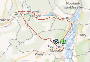
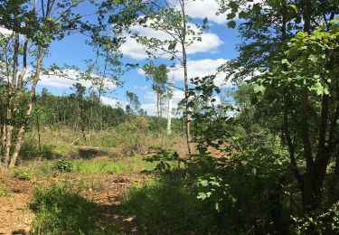
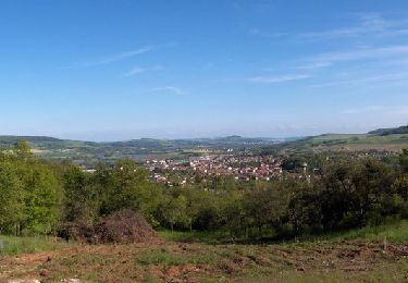
Tour Wandern von 18,1 km verfügbar auf Großer Osten, Mörthe und Mosel, Pagny-sur-Moselle. Diese Tour wird von joelclaudel vorgeschlagen.
Beschreibung
Circuit au départ de la gare de Pagny sur Moselle,issu du guide touristique de la ville de Pagny sur Moselle.
Balisage rectangle jaune n°3.
Ort
Land:
France
Region :
Großer Osten
Abteilung/Provinz :
Mörthe und Mosel
Kommune :
Pagny-sur-Moselle
Standort:
Unknown
Gehen Sie:(Dec)
Gehen Sie:(UTM)
282343 ; 5430066 (32U) N.
Kommentare
Touren in der Umgebung
![Tour Zu Fuß Arry - Circuit d'Arry Nord - Photo](https://media.geolcdn.com/t/375/260/3c0e2cec-70a5-424b-afe0-bda5787030da.jpeg&format=jpg&maxdim=2)
![Zu Fuß Zu Fuß](https://static1.geolcdn.com/sitytour/trail-icons/100.png)
Circuit d'Arry Nord
Zu Fuß
Einfach
Arry,
Großer Osten,
Mosel,
France
![](/images/other/stat-length.png)
3,4 km | 4,2 km-effort
57min
![](https://static1.geolcdn.com/siteimages/upload/files/16400158638029165_repeat_loop_refresh_sync_direction_icon.png)
Nein
![Tour Wandern Arry - Arry - côte Saint Pierre - Vezon - Marieulles - Lorry Mardigny - Arry - Photo](https://media.geolcdn.com/t/375/260/ff937aea-a994-4209-8ca1-ce9cd46d81d8.jpg&format=jpg&maxdim=2)
![Wandern Wandern](https://static1.geolcdn.com/sitytour/trail-icons/101.png)
Arry - côte Saint Pierre - Vezon - Marieulles - Lorry Mardigny - Arry
Wandern
Medium
Arry,
Großer Osten,
Mosel,
France
![](/images/other/stat-length.png)
13,9 km | 18 km-effort
24h 12min
![](https://static1.geolcdn.com/siteimages/upload/files/16400158638029165_repeat_loop_refresh_sync_direction_icon.png)
Ja
![Tour Wandern Champey-sur-Moselle - CHAMPEY - LA FRONTIERE - Photo](https://media.geolcdn.com/t/375/260/5293a82e-2a6e-43d7-9a10-ac23494bc253.jpg&format=jpg&maxdim=2)
![Wandern Wandern](https://static1.geolcdn.com/sitytour/trail-icons/101.png)
CHAMPEY - LA FRONTIERE
Wandern
Einfach
Champey-sur-Moselle,
Großer Osten,
Mörthe und Mosel,
France
![](/images/other/stat-length.png)
10,7 km | 14,5 km-effort
3h 31min
![](https://static1.geolcdn.com/siteimages/upload/files/16400158638029165_repeat_loop_refresh_sync_direction_icon.png)
Ja
![Tour Wandern Arnaville - ARNAVILLE - LES AÏTRES MEDIEVAUX - Photo](https://media.geolcdn.com/t/375/260/d37deaa3-5f14-412c-9d83-a46e5622a12e.jpg&format=jpg&maxdim=2)
![Wandern Wandern](https://static1.geolcdn.com/sitytour/trail-icons/101.png)
ARNAVILLE - LES AÏTRES MEDIEVAUX
Wandern
Einfach
Arnaville,
Großer Osten,
Mörthe und Mosel,
France
![](/images/other/stat-length.png)
12,7 km | 15,6 km-effort
3h 51min
![](https://static1.geolcdn.com/siteimages/upload/files/16400158638029165_repeat_loop_refresh_sync_direction_icon.png)
Ja
![Tour Wandern Arnaville - ARNAVILLE - LA VALLEE DU RUPT DE MAD - Photo](https://media.geolcdn.com/t/375/260/0c24bd03-483c-4f8f-b6a8-2e730119a0b2.jpg&format=jpg&maxdim=2)
![Wandern Wandern](https://static1.geolcdn.com/sitytour/trail-icons/101.png)
ARNAVILLE - LA VALLEE DU RUPT DE MAD
Wandern
Einfach
Arnaville,
Großer Osten,
Mörthe und Mosel,
France
![](/images/other/stat-length.png)
9,9 km | 13,5 km-effort
3h 55min
![](https://static1.geolcdn.com/siteimages/upload/files/16400158638029165_repeat_loop_refresh_sync_direction_icon.png)
Ja
![Tour Wandern Pagny-sur-Moselle - PAGNY SUR MOSELLE - VAL ET PLATEAU - Photo](https://media.geolcdn.com/t/375/260/dee2092b-e619-4a0a-95ba-1af28af57431.jpg&format=jpg&maxdim=2)
![Wandern Wandern](https://static1.geolcdn.com/sitytour/trail-icons/101.png)
PAGNY SUR MOSELLE - VAL ET PLATEAU
Wandern
Medium
Pagny-sur-Moselle,
Großer Osten,
Mörthe und Mosel,
France
![](/images/other/stat-length.png)
18,1 km | 23 km-effort
6h 46min
![](https://static1.geolcdn.com/siteimages/upload/files/16400158638029165_repeat_loop_refresh_sync_direction_icon.png)
Ja
![Tour Wandern Prény - Forêt de Preny dévastée quelle dommage - Photo](https://media.geolcdn.com/t/375/260/1f50b1f7-4c8a-4c2b-b85a-6e1416c0eb49.jpg&format=jpg&maxdim=2)
![Wandern Wandern](https://static1.geolcdn.com/sitytour/trail-icons/101.png)
Forêt de Preny dévastée quelle dommage
Wandern
Medium
Prény,
Großer Osten,
Mörthe und Mosel,
France
![](/images/other/stat-length.png)
7,4 km | 9,7 km-effort
1h 14min
![](https://static1.geolcdn.com/siteimages/upload/files/16400158638029165_repeat_loop_refresh_sync_direction_icon.png)
Nein
![Tour Wandern Prény - Marche Prény 2017 - Photo](https://media.geolcdn.com/t/375/260/ext.jpg?maxdim=2&url=https%3A%2F%2Fstatic1.geolcdn.com%2Fsiteimages%2Fupload%2Ffiles%2F1553511878bg_sport_marche.png)
![Wandern Wandern](https://static1.geolcdn.com/sitytour/trail-icons/101.png)
Marche Prény 2017
Wandern
Medium
(1)
Prény,
Großer Osten,
Mörthe und Mosel,
France
![](/images/other/stat-length.png)
9,5 km | 13 km-effort
2h 41min
![](https://static1.geolcdn.com/siteimages/upload/files/16400158638029165_repeat_loop_refresh_sync_direction_icon.png)
Ja
![Tour Mountainbike Pagny-sur-Moselle - Vélo et Nature 2014 - Pagny sur Moselle - Photo](https://media.geolcdn.com/t/375/260/ext.jpg?maxdim=2&url=https%3A%2F%2Fservices.sitytrail.com%2FGeolivesWS%2FDownloadMedia.ashx%3FTrailID%3D317805%26Media%3D17136_6.jpg)
![Mountainbike Mountainbike](https://static1.geolcdn.com/sitytour/trail-icons/202.png)
Vélo et Nature 2014 - Pagny sur Moselle
Mountainbike
Medium
Pagny-sur-Moselle,
Großer Osten,
Mörthe und Mosel,
France
![](/images/other/stat-length.png)
34 km | 43 km-effort
2h 0min
![](https://static1.geolcdn.com/siteimages/upload/files/16400158638029165_repeat_loop_refresh_sync_direction_icon.png)
Ja