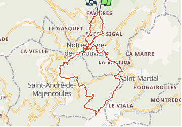
![](/images/other/stat-length.png)
![Tour Wandern Val-d'Aigoual - valbonne - Photo](https://media.geolcdn.com/t/1900/400/ext.pjpeg?maxdim=2&url=https%3A%2F%2Fstatic1.geolcdn.com%2Fsiteimages%2Fupload%2Ffiles%2F1553511878bg_sport_marche.png)
valbonne
mbc
Benutzer
![Länge](/images/other/stat-length.png)
![Maximale Höhe](https://static1.geolcdn.com/siteimages/upload/files/1508320355ic_sort_altitude_max_24dp.png)
![Positive Höhendifferenz](https://static1.geolcdn.com/siteimages/upload/files/1508320355ic_sort_den_pos_24dp.png)
![Km-Effort](/images/other/stat-length.png)
![Min. Höhe](https://static1.geolcdn.com/siteimages/upload/files/1508320355ic_sort_altitude_min_24dp.png)
![Negative Höhendifferenz](https://static1.geolcdn.com/siteimages/upload/files/1508320355ic_sort_den_neg_24dp.png)
![Boucle](https://static1.geolcdn.com/siteimages/upload/files/16400158638029165_repeat_loop_refresh_sync_direction_icon.png)
![Wandern](https://static1.geolcdn.com/sitytour/trail-icons/101.png)
7h04
Schwierigkeit : Medium
![Scannen Sie diesen QR-Code, um die Tour in der SityTrail-Anwendung zu öffnen](https://capi.geolives.com/qq0zvz2zws4bq2lad0pu/sitytour/trails/608245/qr.png?size=200)
Kostenlosegpshiking-Anwendung
Über SityTrail
Tour Wandern von 20 km verfügbar auf Okzitanien, Gard, Val-d'Aigoual. Diese Tour wird von mbc vorgeschlagen.
Beschreibung
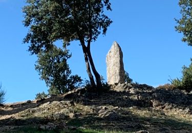
depuis Favières, dirigez vous vers Puech sigal, puis notre Dame de la rouvière, suivre la route sur gauche jusqu'à l'euziere, tournez à droite le mas Tidouls, après le pont qui passe sur la valnierette, suivre le panneau sur droite vers la Bastide, puis le col de la Tribale. au carrefour prendre à droite la D420 sur 300m puis à gauche prendre le chemin vers le peze, continuer le chemin jusqu'au col du Devinayre, continuer dand les bois jusqu'au col de Peyreraube, descendre jusquà Valbonne le haut, suite gite, puis col de cabonne, traversser la route, et prendre le chemin en face, en arrivant sur la route, continuer jusquau hameau du Vignal, suivez les panneaux jaunes qui vous conduises ver Notre Dame, puis Favières.
Ort
Kommentare
Touren in der Umgebung
![Tour Wandern Les Plantiers - Vallée Borgne - Photo](https://media.geolcdn.com/t/375/260/f18dfe3f-f9df-4e1d-8dc9-6aeab33ebafe.jpg&format=jpg&maxdim=2)
![Wandern Wandern](https://static1.geolcdn.com/sitytour/trail-icons/101.png)
Wandern
![](/images/other/stat-length.png)
![](https://static1.geolcdn.com/siteimages/upload/files/16400158638029165_repeat_loop_refresh_sync_direction_icon.png)
![Tour Wandern Les Plantiers - Sentier du Mouflon - Les Plantiers - Photo](https://media.geolcdn.com/t/375/260/ext.jpg?maxdim=2&url=https%3A%2F%2Fservices.sitytrail.com%2FGeolivesWS%2FDownloadMedia.ashx%3FTrailID%3D223509%26Media%3D802317c0-3594-4820-adb2-76eafc969123.jpg)
![Wandern Wandern](https://static1.geolcdn.com/sitytour/trail-icons/101.png)
Wandern
![](/images/other/stat-length.png)
![](https://static1.geolcdn.com/siteimages/upload/files/16400158638029165_repeat_loop_refresh_sync_direction_icon.png)
![Tour Wandern Les Plantiers - la Becede - Photo](https://media.geolcdn.com/t/375/260/c63ee19f-e327-4605-afa8-b6997f966226.jpg&format=jpg&maxdim=2)
![Wandern Wandern](https://static1.geolcdn.com/sitytour/trail-icons/101.png)
Wandern
![](/images/other/stat-length.png)
![](https://static1.geolcdn.com/siteimages/upload/files/16400158638029165_repeat_loop_refresh_sync_direction_icon.png)
![Tour Wandern Saint-Martial - Montagne du Liron au départ de St Martial - Photo](https://media.geolcdn.com/t/375/260/230ffbae-9a5c-40a3-841b-ca21b92f7b5b.jpg&format=jpg&maxdim=2)
![Wandern Wandern](https://static1.geolcdn.com/sitytour/trail-icons/101.png)
Wandern
![](/images/other/stat-length.png)
![](https://static1.geolcdn.com/siteimages/upload/files/16400158638029165_repeat_loop_refresh_sync_direction_icon.png)
![Tour Wandern Saint-Martial - arsel saint martial - Photo](https://media.geolcdn.com/t/375/260/7eb2b09d-8664-4214-8948-fa1b3d75088d.jpg&format=jpg&maxdim=2)
![Wandern Wandern](https://static1.geolcdn.com/sitytour/trail-icons/101.png)
Wandern
![](/images/other/stat-length.png)
![](https://static1.geolcdn.com/siteimages/upload/files/16400158638029165_repeat_loop_refresh_sync_direction_icon.png)
![Tour Wandern Saint-Martial - Le col de la Tribale Le col de Bez Saint Martial - Photo](https://media.geolcdn.com/t/375/260/0af33f45-6d63-4012-ba0f-17fafc71089a.jpg&format=jpg&maxdim=2)
![Wandern Wandern](https://static1.geolcdn.com/sitytour/trail-icons/101.png)
Wandern
![](/images/other/stat-length.png)
![](https://static1.geolcdn.com/siteimages/upload/files/16400158638029165_repeat_loop_refresh_sync_direction_icon.png)
![Tour Wandern Val-d'Aigoual - Col d’asclier rocher de l’aigle - Photo](https://media.geolcdn.com/t/375/260/e49f7a07-a5de-4fa9-bcfd-dcb200f0c4b6.jpg&format=jpg&maxdim=2)
![Wandern Wandern](https://static1.geolcdn.com/sitytour/trail-icons/101.png)
Wandern
![](/images/other/stat-length.png)
![](https://static1.geolcdn.com/siteimages/upload/files/16400158638029165_repeat_loop_refresh_sync_direction_icon.png)
![Tour Hybrid-Bike Saint-Martial - Saint martial valleraurgues - Photo](https://media.geolcdn.com/t/375/260/a0de356b-be13-4cf8-8e9d-606398e1292b.jpg&format=jpg&maxdim=2)
![Hybrid-Bike Hybrid-Bike](https://static1.geolcdn.com/sitytour/trail-icons/203.png)
Hybrid-Bike
![](/images/other/stat-length.png)
![](https://static1.geolcdn.com/siteimages/upload/files/16400158638029165_repeat_loop_refresh_sync_direction_icon.png)
![Tour Wandern Saint-Martial - Saint martial 3 cols - Photo](https://media.geolcdn.com/t/375/260/228a30cc-92d6-48a9-8ed8-4c846283f017.jpg&format=jpg&maxdim=2)
![Wandern Wandern](https://static1.geolcdn.com/sitytour/trail-icons/101.png)
Wandern
![](/images/other/stat-length.png)
![](https://static1.geolcdn.com/siteimages/upload/files/16400158638029165_repeat_loop_refresh_sync_direction_icon.png)