![](/images/other/stat-length.png)
![Tour Mountainbike Prémanon - randonnée vtt - Photo](https://media.geolcdn.com/t/1900/400/ext.pjpeg?maxdim=2&url=https%3A%2F%2Fstatic1.geolcdn.com%2Fsiteimages%2Fupload%2Ffiles%2F1524743154velo.jpg)
randonnée vtt
Christophe.39
Benutzer
![Länge](/images/other/stat-length.png)
Länge
23 km
![Maximale Höhe](https://static1.geolcdn.com/siteimages/upload/files/1508320355ic_sort_altitude_max_24dp.png)
Maximale Höhe
1318 m
![Positive Höhendifferenz](https://static1.geolcdn.com/siteimages/upload/files/1508320355ic_sort_den_pos_24dp.png)
Positive Höhendifferenz
587 m
![Km-Effort](/images/other/stat-length.png)
Km-Effort
31 km
![Min. Höhe](https://static1.geolcdn.com/siteimages/upload/files/1508320355ic_sort_altitude_min_24dp.png)
Min. Höhe
862 m
![Negative Höhendifferenz](https://static1.geolcdn.com/siteimages/upload/files/1508320355ic_sort_den_neg_24dp.png)
Negative Höhendifferenz
585 m
![Boucle](https://static1.geolcdn.com/siteimages/upload/files/16400158638029165_repeat_loop_refresh_sync_direction_icon.png)
Boucle
Ja
Erstellungsdatum :
2017-04-07 00:00:00.0
Letzte Änderung :
2017-04-07 00:00:00.0
![Mountainbike](https://static1.geolcdn.com/sitytour/trail-icons/202.png)
1h59
Schwierigkeit : Medium
![Scannen Sie diesen QR-Code, um die Tour in der SityTrail-Anwendung zu öffnen](https://capi.geolives.com/qq0zvz2zws4bq2lad0pu/sitytour/trails/608029/qr.png?size=200)
Kostenlosegpshiking-Anwendung
Über SityTrail
Tour Mountainbike von 23 km verfügbar auf Burgund und Freigrafschaft, Jura, Prémanon. Diese Tour wird von Christophe.39 vorgeschlagen.
Beschreibung
Éclatage pneus arrière et retour route avec réparation de fortune.sinon beau paysage du haut jura.
Ort
Land:
France
Region :
Burgund und Freigrafschaft
Abteilung/Provinz :
Jura
Kommune :
Prémanon
Standort:
Unknown
Gehen Sie:(Dec)
Gehen Sie:(UTM)
271529 ; 5151563 (32T) N.
Kommentare
Touren in der Umgebung
![Tour Fahrrad - Lac de Lamoura et Valserine - Prémanon - Photo](https://media.geolcdn.com/t/375/260/ext.jpg?maxdim=2&url=https%3A%2F%2Fservices.sitytrail.com%2FGeolivesWS%2FDownloadMedia.ashx%3FTrailID%3D317353%26Media%3D16571_5.jpg)
![Fahrrad Fahrrad](https://static1.geolcdn.com/sitytour/trail-icons/200.png)
Lac de Lamoura et Valserine - Prémanon
Fahrrad
Medium
(1)
,
Burgund und Freigrafschaft,
Jura,
France
![](/images/other/stat-length.png)
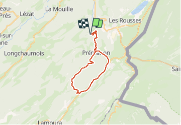
39 km | 49 km-effort
2h 0min
![](https://static1.geolcdn.com/siteimages/upload/files/16400158638029165_repeat_loop_refresh_sync_direction_icon.png)
Ja
![Tour Wandern - Le Belvédère des Maquisards - Prémanon - Photo](https://media.geolcdn.com/t/375/260/ext.jpg?maxdim=2&url=https%3A%2F%2Fservices.sitytrail.com%2FGeolivesWS%2FDownloadMedia.ashx%3FTrailID%3D191470%26Media%3D15062_5.jpg)
![Wandern Wandern](https://static1.geolcdn.com/sitytour/trail-icons/101.png)
Le Belvédère des Maquisards - Prémanon
Wandern
Medium
(1)
,
Burgund und Freigrafschaft,
Jura,
France
![](/images/other/stat-length.png)
5,4 km | 7,8 km-effort
2h 0min
![](https://static1.geolcdn.com/siteimages/upload/files/16400158638029165_repeat_loop_refresh_sync_direction_icon.png)
Ja
![Tour Wandern - Autour de Prémanon - Photo](https://media.geolcdn.com/t/375/260/ext.jpg?maxdim=2&url=https%3A%2F%2Fservices.sitytrail.com%2FGeolivesWS%2FDownloadMedia.ashx%3FTrailID%3D191468%26Media%3D15060_4.jpg)
![Wandern Wandern](https://static1.geolcdn.com/sitytour/trail-icons/101.png)
Autour de Prémanon
Wandern
Sehr schwierig
(1)
,
Burgund und Freigrafschaft,
Jura,
France
![](/images/other/stat-length.png)
18 km | 27 km-effort
6h 0min
![](https://static1.geolcdn.com/siteimages/upload/files/16400158638029165_repeat_loop_refresh_sync_direction_icon.png)
Ja
![Tour Wandern Les Rousses - Le Noirmont - Les Rousses - Photo](https://media.geolcdn.com/t/375/260/ext.jpg?maxdim=2&url=https%3A%2F%2Fservices.sitytrail.com%2FGeolivesWS%2FDownloadMedia.ashx%3FTrailID%3D191437%26Media%3D15025_5.jpg)
![Wandern Wandern](https://static1.geolcdn.com/sitytour/trail-icons/101.png)
Le Noirmont - Les Rousses
Wandern
Sehr schwierig
(2)
Les Rousses,
Burgund und Freigrafschaft,
Jura,
France
![](/images/other/stat-length.png)
15,1 km | 23 km-effort
6h 0min
![](https://static1.geolcdn.com/siteimages/upload/files/16400158638029165_repeat_loop_refresh_sync_direction_icon.png)
Ja
![Tour Wandern Prémanon - dole1 - Photo](https://media.geolcdn.com/t/375/260/ext.jpg?maxdim=2&url=https%3A%2F%2Fservices.sitytrail.com%2FGeolivesWS%2FDownloadMedia.ashx%3FTrailID%3D136383%26Media%3D20120623131628.jpg)
![Wandern Wandern](https://static1.geolcdn.com/sitytour/trail-icons/101.png)
dole1
Wandern
Sehr leicht
(2)
Prémanon,
Burgund und Freigrafschaft,
Jura,
France
![](/images/other/stat-length.png)
6,6 km | 12,5 km-effort
1h 49min
![](https://static1.geolcdn.com/siteimages/upload/files/16400158638029165_repeat_loop_refresh_sync_direction_icon.png)
Ja
![Tour Zu Fuß - Les Arcets - Photo](https://media.geolcdn.com/t/375/260/dbf9401a-4a63-43b8-9f8e-030f59772016.jpeg&format=jpg&maxdim=2)
![Zu Fuß Zu Fuß](https://static1.geolcdn.com/sitytour/trail-icons/100.png)
Les Arcets
Zu Fuß
Einfach
,
Burgund und Freigrafschaft,
Jura,
France
![](/images/other/stat-length.png)
9 km | 13,6 km-effort
3h 5min
![](https://static1.geolcdn.com/siteimages/upload/files/16400158638029165_repeat_loop_refresh_sync_direction_icon.png)
Ja
![Tour Wandern - Prémanon, Mont Fier - Photo](https://media.geolcdn.com/t/375/260/ext.jpg?maxdim=2&url=https%3A%2F%2Fstatic1.geolcdn.com%2Fsiteimages%2Fupload%2Ffiles%2F1553511878bg_sport_marche.png)
![Wandern Wandern](https://static1.geolcdn.com/sitytour/trail-icons/101.png)
Prémanon, Mont Fier
Wandern
Sehr leicht
(1)
,
Burgund und Freigrafschaft,
Jura,
France
![](/images/other/stat-length.png)
10,9 km | 15,8 km-effort
2h 34min
![](https://static1.geolcdn.com/siteimages/upload/files/16400158638029165_repeat_loop_refresh_sync_direction_icon.png)
Nein
![Tour Schneeschuhwandern Les Rousses - Lac des Rousses - Photo](https://media.geolcdn.com/t/375/260/ext.jpg?maxdim=2&url=https%3A%2F%2Fstatic1.geolcdn.com%2Fsiteimages%2Fupload%2Ffiles%2F1524743153raquette.jpg)
![Schneeschuhwandern Schneeschuhwandern](https://static1.geolcdn.com/sitytour/trail-icons/504.png)
Lac des Rousses
Schneeschuhwandern
Medium
(1)
Les Rousses,
Burgund und Freigrafschaft,
Jura,
France
![](/images/other/stat-length.png)
13,8 km | 18,4 km-effort
4h 15min
![](https://static1.geolcdn.com/siteimages/upload/files/16400158638029165_repeat_loop_refresh_sync_direction_icon.png)
Ja
![Tour Wandern Prémanon - mon 8 de La DÔLE - Photo](https://media.geolcdn.com/t/375/260/19466126-b34e-426d-b8cd-3843abcfd6ed.jpg&format=jpg&maxdim=2)
![Wandern Wandern](https://static1.geolcdn.com/sitytour/trail-icons/101.png)
mon 8 de La DÔLE
Wandern
Medium
Prémanon,
Burgund und Freigrafschaft,
Jura,
France
![](/images/other/stat-length.png)
8,3 km | 14,5 km-effort
4h 23min
![](https://static1.geolcdn.com/siteimages/upload/files/16400158638029165_repeat_loop_refresh_sync_direction_icon.png)
Ja