![](/images/other/stat-length.png)
![Tour Wandern Sacoué - tourroc en boucle depuis Sacoue - Photo](https://media.geolcdn.com/t/1900/400/ext.pjpeg?maxdim=2&url=https%3A%2F%2Fstatic1.geolcdn.com%2Fsiteimages%2Fupload%2Ffiles%2F1553511878bg_sport_marche.png)
tourroc en boucle depuis Sacoue
dawed311
Benutzer
![Länge](/images/other/stat-length.png)
![Maximale Höhe](https://static1.geolcdn.com/siteimages/upload/files/1508320355ic_sort_altitude_max_24dp.png)
![Positive Höhendifferenz](https://static1.geolcdn.com/siteimages/upload/files/1508320355ic_sort_den_pos_24dp.png)
![Km-Effort](/images/other/stat-length.png)
![Min. Höhe](https://static1.geolcdn.com/siteimages/upload/files/1508320355ic_sort_altitude_min_24dp.png)
![Negative Höhendifferenz](https://static1.geolcdn.com/siteimages/upload/files/1508320355ic_sort_den_neg_24dp.png)
![Boucle](https://static1.geolcdn.com/siteimages/upload/files/16400158638029165_repeat_loop_refresh_sync_direction_icon.png)
![Wandern](https://static1.geolcdn.com/sitytour/trail-icons/101.png)
5h19
Schwierigkeit : Medium
![Scannen Sie diesen QR-Code, um die Tour in der SityTrail-Anwendung zu öffnen](https://capi.geolives.com/qq0zvz2zws4bq2lad0pu/sitytour/trails/599875/qr.png?size=200)
Kostenlosegpshiking-Anwendung
Über SityTrail
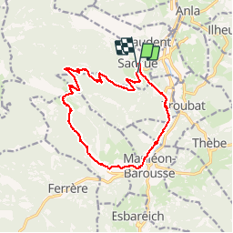
Tour Wandern von 17,6 km verfügbar auf Okzitanien, Hautes-Pyrénées, Sacoué. Diese Tour wird von dawed311 vorgeschlagen.
Beschreibung
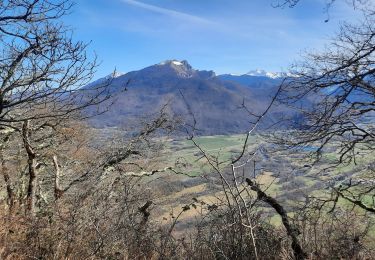
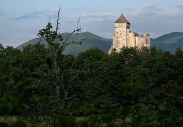
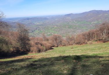
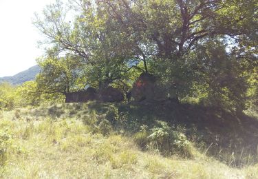
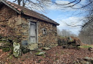
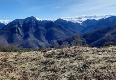
Pic du Tourroc et redescente vers Ourde, Mauleon et Bramevaque(chateau). Peu connu, le pic du Tourroc est pourtant un beau belvédère sur la plaine du Comminges et les sommets du Luchonnais. Le circuit comprend une grande boucle, hors sentier, jusqu'au chateau des comtes du Comminges à Bramevaque. Il est possible d'écourter la randonnée en empruntant la piste forestière en voiture. La montée au pic du Tourroc ne présente aucune difficulté et peut se faire l'hiver en raquette.
Ort
Kommentare
Touren in der Umgebung
![Tour Wandern Saint-Bertrand-de-Comminges - Autour de Saint Bertrand de Comminges - Photo](https://media.geolcdn.com/t/375/260/ext.jpg?maxdim=2&url=https%3A%2F%2Fservices.sitytrail.com%2FGeolivesWS%2FDownloadMedia.ashx%3FTrailID%3D129679%26Media%3D13211_5.jpg)
![Wandern Wandern](https://static1.geolcdn.com/sitytour/trail-icons/101.png)
Wandern
![](/images/other/stat-length.png)
![](https://static1.geolcdn.com/siteimages/upload/files/16400158638029165_repeat_loop_refresh_sync_direction_icon.png)
![Tour Wandern Antichan - sommet d'Herbe Rouge en boucle depuis Antichan - Photo](https://media.geolcdn.com/t/375/260/2676d141-2d54-4591-a0ca-fc3fcbbbc6ad.jpg&format=jpg&maxdim=2)
![Wandern Wandern](https://static1.geolcdn.com/sitytour/trail-icons/101.png)
Wandern
![](/images/other/stat-length.png)
![](https://static1.geolcdn.com/siteimages/upload/files/16400158638029165_repeat_loop_refresh_sync_direction_icon.png)
![Tour Zu Fuß Saint-Bertrand-de-Comminges - Saint-Bertrand-de-Comminges : au coeur du Comminges - Photo](https://media.geolcdn.com/t/375/260/d01fb659-cf60-479b-909a-8da927ef2c5e.jpeg&format=jpg&maxdim=2)
![Zu Fuß Zu Fuß](https://static1.geolcdn.com/sitytour/trail-icons/100.png)
Zu Fuß
![](/images/other/stat-length.png)
![](https://static1.geolcdn.com/siteimages/upload/files/16400158638029165_repeat_loop_refresh_sync_direction_icon.png)
![Wandern Wandern](https://static1.geolcdn.com/sitytour/trail-icons/101.png)
Wandern
![](/images/other/stat-length.png)
![](https://static1.geolcdn.com/siteimages/upload/files/16400158638029165_repeat_loop_refresh_sync_direction_icon.png)
![Tour Wandern Mauléon-Barousse - MAULEON BAROUSSE la rando de Payremilla (G3) faite le 23/10/2020 - Photo](https://media.geolcdn.com/t/375/260/f54aedb7-7843-4cd9-8363-8502c158108a.jpg&format=jpg&maxdim=2)
![Wandern Wandern](https://static1.geolcdn.com/sitytour/trail-icons/101.png)
Wandern
![](/images/other/stat-length.png)
![](https://static1.geolcdn.com/siteimages/upload/files/16400158638029165_repeat_loop_refresh_sync_direction_icon.png)
![Tour Wandern Bramevaque - randonnée sur le Touroc depuis Bramevaque - Photo](https://media.geolcdn.com/t/375/260/11044ee2-ac3e-40d6-87ed-897d2a6f400f.jpg&format=jpg&maxdim=2)
![Wandern Wandern](https://static1.geolcdn.com/sitytour/trail-icons/101.png)
Wandern
![](/images/other/stat-length.png)
![](https://static1.geolcdn.com/siteimages/upload/files/16400158638029165_repeat_loop_refresh_sync_direction_icon.png)
![Tour Wandern Mauléon-Barousse - MAULEON BAROUSSE Circuit des amis du Lac](https://media.geolcdn.com/t/375/260/514ad499-f66e-4243-b144-7abeb20a1a25.jpg&format=jpg&maxdim=2)
![Wandern Wandern](https://static1.geolcdn.com/sitytour/trail-icons/101.png)
Wandern
![](/images/other/stat-length.png)
![](https://static1.geolcdn.com/siteimages/upload/files/16400158638029165_repeat_loop_refresh_sync_direction_icon.png)
![Tour Wandern Ferrère - pic de Douly en boucle depuis Ferrère - Photo](https://media.geolcdn.com/t/375/260/c7147a1a-6f87-4c7b-aaa1-5f3c152be715.jpg&format=jpg&maxdim=2)
![Wandern Wandern](https://static1.geolcdn.com/sitytour/trail-icons/101.png)
Wandern
![](/images/other/stat-length.png)
![](https://static1.geolcdn.com/siteimages/upload/files/16400158638029165_repeat_loop_refresh_sync_direction_icon.png)
![Tour Wandern Sacoué - marrouye depuis le pied du Touroc - Photo](https://media.geolcdn.com/t/375/260/0ada9eb7-2f86-4640-922c-3c6782533cb1.jpg&format=jpg&maxdim=2)
![Wandern Wandern](https://static1.geolcdn.com/sitytour/trail-icons/101.png)
Wandern
![](/images/other/stat-length.png)
![](https://static1.geolcdn.com/siteimages/upload/files/16400158638029165_repeat_loop_refresh_sync_direction_icon.png)