![](/images/other/stat-length.png)
![Tour Wandern Templeuve-en-Pévèle - Par le coin de la reine - Photo](https://media.geolcdn.com/t/1900/400/ext.pjpeg?maxdim=2&url=https%3A%2F%2Fstatic1.geolcdn.com%2Fsiteimages%2Fupload%2Ffiles%2F1553511878bg_sport_marche.png)
Par le coin de la reine
camino59
Benutzer
![Länge](/images/other/stat-length.png)
Länge
21 km
![Maximale Höhe](https://static1.geolcdn.com/siteimages/upload/files/1508320355ic_sort_altitude_max_24dp.png)
Maximale Höhe
57 m
![Positive Höhendifferenz](https://static1.geolcdn.com/siteimages/upload/files/1508320355ic_sort_den_pos_24dp.png)
Positive Höhendifferenz
97 m
![Km-Effort](/images/other/stat-length.png)
Km-Effort
22 km
![Min. Höhe](https://static1.geolcdn.com/siteimages/upload/files/1508320355ic_sort_altitude_min_24dp.png)
Min. Höhe
27 m
![Negative Höhendifferenz](https://static1.geolcdn.com/siteimages/upload/files/1508320355ic_sort_den_neg_24dp.png)
Negative Höhendifferenz
97 m
![Boucle](https://static1.geolcdn.com/siteimages/upload/files/16400158638029165_repeat_loop_refresh_sync_direction_icon.png)
Boucle
Ja
Erstellungsdatum :
2016-06-24 00:00:00.0
Letzte Änderung :
2016-06-24 00:00:00.0
![Wandern](https://static1.geolcdn.com/sitytour/trail-icons/101.png)
4h59
Schwierigkeit : Einfach
![Scannen Sie diesen QR-Code, um die Tour in der SityTrail-Anwendung zu öffnen](https://capi.geolives.com/qq0zvz2zws4bq2lad0pu/sitytour/trails/585463/qr.png?size=200)
Kostenlosegpshiking-Anwendung
Über SityTrail
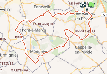
Tour Wandern von 21 km verfügbar auf Nordfrankreich, Nord, Templeuve-en-Pévèle. Diese Tour wird von camino59 vorgeschlagen.
Beschreibung
Départ du moulin de Vertain. On rejoint ensuite le GR 121B et on empruntera la boie verte de la Pévèle pour revenir par Molpas et retourner vers Templeuve
Ort
Land:
France
Region :
Nordfrankreich
Abteilung/Provinz :
Nord
Kommune :
Templeuve-en-Pévèle
Standort:
Unknown
Gehen Sie:(Dec)
Gehen Sie:(UTM)
512564 ; 5598281 (31U) N.
Kommentare
Touren in der Umgebung
![Tour Pferd Cappelle-en-Pévèle - Boucle des Pavés - Capelle en Pévèle - Photo](https://media.geolcdn.com/t/375/260/ext.jpg?maxdim=2&url=https%3A%2F%2Fservices.sitytrail.com%2FGeolivesWS%2FDownloadMedia.ashx%3FTrailID%3D172678%26Media%3D14060_5.jpg)
![Pferd Pferd](https://static1.geolcdn.com/sitytour/trail-icons/300.png)
Boucle des Pavés - Capelle en Pévèle
Pferd
Medium
(1)
Cappelle-en-Pévèle,
Nordfrankreich,
Nord,
France
![](/images/other/stat-length.png)
17,7 km | 18,7 km-effort
2h 45min
![](https://static1.geolcdn.com/siteimages/upload/files/16400158638029165_repeat_loop_refresh_sync_direction_icon.png)
Ja
![Tour Wandern Ennevelin - Circuit d'Aigremont - Photo](https://media.geolcdn.com/t/375/260/ext.jpg?maxdim=2&url=https%3A%2F%2Fservices.sitytrail.com%2FGeolivesWS%2FDownloadMedia.ashx%3FTrailID%3D109029%26Media%3D2987_6.jpg)
![Wandern Wandern](https://static1.geolcdn.com/sitytour/trail-icons/101.png)
Circuit d'Aigremont
Wandern
Medium
(1)
Ennevelin,
Nordfrankreich,
Nord,
France
![](/images/other/stat-length.png)
11,1 km | 11,8 km-effort
2h 45min
![](https://static1.geolcdn.com/siteimages/upload/files/16400158638029165_repeat_loop_refresh_sync_direction_icon.png)
Ja
![Tour Wandern Cobrieux - Circuit de la Commanderie à Cobrieux - Photo](https://media.geolcdn.com/t/375/260/ext.jpg?maxdim=2&url=https%3A%2F%2Fservices.sitytrail.com%2FGeolivesWS%2FDownloadMedia.ashx%3FTrailID%3D108840%26Media%3D2350_5.jpg)
![Wandern Wandern](https://static1.geolcdn.com/sitytour/trail-icons/101.png)
Circuit de la Commanderie à Cobrieux
Wandern
Medium
(1)
Cobrieux,
Nordfrankreich,
Nord,
France
![](/images/other/stat-length.png)
11,8 km | 12,9 km-effort
3h 0min
![](https://static1.geolcdn.com/siteimages/upload/files/16400158638029165_repeat_loop_refresh_sync_direction_icon.png)
Ja
![Tour Wandern Péronne-en-Mélantois - Péronne en Mélantois et ses marais - Photo](https://media.geolcdn.com/t/375/260/ext.jpg?maxdim=2&url=https%3A%2F%2Fservices.sitytrail.com%2FGeolivesWS%2FDownloadMedia.ashx%3FTrailID%3D108801%26Media%3D2113_4.jpg)
![Wandern Wandern](https://static1.geolcdn.com/sitytour/trail-icons/101.png)
Péronne en Mélantois et ses marais
Wandern
Medium
(1)
Péronne-en-Mélantois,
Nordfrankreich,
Nord,
France
![](/images/other/stat-length.png)
13,1 km | 14 km-effort
3h 15min
![](https://static1.geolcdn.com/siteimages/upload/files/16400158638029165_repeat_loop_refresh_sync_direction_icon.png)
Ja
![Tour Wandern Fretin - Mélantois - La Marque - Photo](https://media.geolcdn.com/t/375/260/e4788ebe-94f6-4fed-806d-677626b10cf7.jpg&format=jpg&maxdim=2)
![Wandern Wandern](https://static1.geolcdn.com/sitytour/trail-icons/101.png)
Mélantois - La Marque
Wandern
Einfach
(1)
Fretin,
Nordfrankreich,
Nord,
France
![](/images/other/stat-length.png)
13,9 km | 14,9 km-effort
3h 10min
![](https://static1.geolcdn.com/siteimages/upload/files/16400158638029165_repeat_loop_refresh_sync_direction_icon.png)
Ja
![Tour Wandern Fretin - Sur les traces de Philippe II Auguste - Photo](https://media.geolcdn.com/t/375/260/ext.jpg?maxdim=2&url=https%3A%2F%2Fstatic1.geolcdn.com%2Fsiteimages%2Fupload%2Ffiles%2F1553511878bg_sport_marche.png)
![Wandern Wandern](https://static1.geolcdn.com/sitytour/trail-icons/101.png)
Sur les traces de Philippe II Auguste
Wandern
Einfach
(1)
Fretin,
Nordfrankreich,
Nord,
France
![](/images/other/stat-length.png)
26 km | 28 km-effort
5h 12min
![](https://static1.geolcdn.com/siteimages/upload/files/16400158638029165_repeat_loop_refresh_sync_direction_icon.png)
Ja
![Tour Wandern Cobrieux - cobrieux - Photo](https://media.geolcdn.com/t/375/260/ext.jpg?maxdim=2&url=https%3A%2F%2Fstatic1.geolcdn.com%2Fsiteimages%2Fupload%2Ffiles%2F1553511878bg_sport_marche.png)
![Wandern Wandern](https://static1.geolcdn.com/sitytour/trail-icons/101.png)
cobrieux
Wandern
Sehr leicht
(1)
Cobrieux,
Nordfrankreich,
Nord,
France
![](/images/other/stat-length.png)
9,5 km | 10,4 km-effort
56min
![](https://static1.geolcdn.com/siteimages/upload/files/16400158638029165_repeat_loop_refresh_sync_direction_icon.png)
Ja
![Tour Wandern Fretin - fretin et ses marais - Photo](https://media.geolcdn.com/t/375/260/ext.jpg?maxdim=2&url=https%3A%2F%2Fstatic1.geolcdn.com%2Fsiteimages%2Fupload%2Ffiles%2F1553511878bg_sport_marche.png)
![Wandern Wandern](https://static1.geolcdn.com/sitytour/trail-icons/101.png)
fretin et ses marais
Wandern
Einfach
(2)
Fretin,
Nordfrankreich,
Nord,
France
![](/images/other/stat-length.png)
12 km | 12,7 km-effort
2h 31min
![](https://static1.geolcdn.com/siteimages/upload/files/16400158638029165_repeat_loop_refresh_sync_direction_icon.png)
Ja
![Tour Wandern Bouvines - Bouvines 16,2 km - Photo](https://media.geolcdn.com/t/375/260/04164ab1-8212-40bd-9505-143355ac7fa8.jpg&format=jpg&maxdim=2)
![Wandern Wandern](https://static1.geolcdn.com/sitytour/trail-icons/101.png)
Bouvines 16,2 km
Wandern
Einfach
Bouvines,
Nordfrankreich,
Nord,
France
![](/images/other/stat-length.png)
16,2 km | 17,3 km-effort
4h 26min
![](https://static1.geolcdn.com/siteimages/upload/files/16400158638029165_repeat_loop_refresh_sync_direction_icon.png)
Ja