![](/images/other/stat-length.png)
![Tour Andere Aktivitäten Mangonville - mangonville3 - Photo](https://media.geolcdn.com/t/1900/400/ext.pjpeg?maxdim=2&url=https%3A%2F%2Fstatic1.geolcdn.com%2Fsiteimages%2Fupload%2Ffiles%2F1545311037marcheuse_200dpi.jpg)
mangonville3
zibane54
Benutzer
![Länge](/images/other/stat-length.png)
Länge
52 km
![Maximale Höhe](https://static1.geolcdn.com/siteimages/upload/files/1508320355ic_sort_altitude_max_24dp.png)
Maximale Höhe
358 m
![Positive Höhendifferenz](https://static1.geolcdn.com/siteimages/upload/files/1508320355ic_sort_den_pos_24dp.png)
Positive Höhendifferenz
639 m
![Km-Effort](/images/other/stat-length.png)
Km-Effort
60 km
![Min. Höhe](https://static1.geolcdn.com/siteimages/upload/files/1508320355ic_sort_altitude_min_24dp.png)
Min. Höhe
233 m
![Negative Höhendifferenz](https://static1.geolcdn.com/siteimages/upload/files/1508320355ic_sort_den_neg_24dp.png)
Negative Höhendifferenz
639 m
![Boucle](https://static1.geolcdn.com/siteimages/upload/files/16400158638029165_repeat_loop_refresh_sync_direction_icon.png)
Boucle
Ja
Erstellungsdatum :
2016-05-15 00:00:00.0
Letzte Änderung :
2016-05-15 00:00:00.0
![Andere Aktivitäten](https://static1.geolcdn.com/sitytour/trail-icons/900.png)
2h30
Schwierigkeit : Medium
![Scannen Sie diesen QR-Code, um die Tour in der SityTrail-Anwendung zu öffnen](https://capi.geolives.com/qq0zvz2zws4bq2lad0pu/sitytour/trails/569216/qr.png?size=200)
Kostenlosegpshiking-Anwendung
Über SityTrail
Tour Andere Aktivitäten von 52 km verfügbar auf Großer Osten, Mörthe und Mosel, Mangonville. Diese Tour wird von zibane54 vorgeschlagen.
Beschreibung
un joli parcours plat sur les premiers KM puis vallonné ensuite. Seule petite difficulté la traversée de villacourt, la petite route pour loromontzey est mal indiqué (mais elle est sympa)
Ort
Land:
France
Region :
Großer Osten
Abteilung/Provinz :
Mörthe und Mosel
Kommune :
Mangonville
Standort:
Unknown
Gehen Sie:(Dec)
Gehen Sie:(UTM)
299605 ; 5370559 (32U) N.
Kommentare
Touren in der Umgebung
![Tour Fahrrad Mangonville - mangonville - Photo](https://media.geolcdn.com/t/375/260/ext.jpg?maxdim=2&url=https%3A%2F%2Fstatic1.geolcdn.com%2Fsiteimages%2Fupload%2Ffiles%2F1524743154velo.jpg)
![Fahrrad Fahrrad](https://static1.geolcdn.com/sitytour/trail-icons/200.png)
mangonville
Fahrrad
Einfach
(2)
Mangonville,
Großer Osten,
Mörthe und Mosel,
France
![](/images/other/stat-length.png)
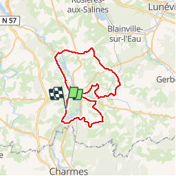
43 km | 50 km-effort
2h 52min
![](https://static1.geolcdn.com/siteimages/upload/files/16400158638029165_repeat_loop_refresh_sync_direction_icon.png)
Nein
![Tour Wandern Bayon - Etang Bayon - Photo](https://media.geolcdn.com/t/375/260/ext.jpg?maxdim=2&url=https%3A%2F%2Fstatic1.geolcdn.com%2Fsiteimages%2Fupload%2Ffiles%2F1553511878bg_sport_marche.png)
![Wandern Wandern](https://static1.geolcdn.com/sitytour/trail-icons/101.png)
Etang Bayon
Wandern
Einfach
Bayon,
Großer Osten,
Mörthe und Mosel,
France
![](/images/other/stat-length.png)
3,4 km | 3,6 km-effort
1h 14min
![](https://static1.geolcdn.com/siteimages/upload/files/16400158638029165_repeat_loop_refresh_sync_direction_icon.png)
Ja
![Tour Elektrofahrrad Bainville-aux-Miroirs - sortie vtt sion 04082022 - Photo](https://media.geolcdn.com/t/375/260/ext.jpg?maxdim=2&url=https%3A%2F%2Fstatic1.geolcdn.com%2Fsiteimages%2Fupload%2Ffiles%2F1524743154velo.jpg)
![Elektrofahrrad Elektrofahrrad](https://static1.geolcdn.com/sitytour/trail-icons/205.png)
sortie vtt sion 04082022
Elektrofahrrad
Schwierig
Bainville-aux-Miroirs,
Großer Osten,
Mörthe und Mosel,
France
![](/images/other/stat-length.png)
51 km | 62 km-effort
3h 22min
![](https://static1.geolcdn.com/siteimages/upload/files/16400158638029165_repeat_loop_refresh_sync_direction_icon.png)
Ja
![Tour Elektrofahrrad Bainville-aux-Miroirs - sortie vtt 08052022 luca - Photo](https://media.geolcdn.com/t/375/260/ext.jpg?maxdim=2&url=https%3A%2F%2Fstatic1.geolcdn.com%2Fsiteimages%2Fupload%2Ffiles%2F1524743154velo.jpg)
![Elektrofahrrad Elektrofahrrad](https://static1.geolcdn.com/sitytour/trail-icons/205.png)
sortie vtt 08052022 luca
Elektrofahrrad
Medium
Bainville-aux-Miroirs,
Großer Osten,
Mörthe und Mosel,
France
![](/images/other/stat-length.png)
42 km | 50 km-effort
2h 36min
![](https://static1.geolcdn.com/siteimages/upload/files/16400158638029165_repeat_loop_refresh_sync_direction_icon.png)
Ja
![Tour Reiten Froville - acpl chez Karine et Danielle froville - Photo](https://media.geolcdn.com/t/375/260/ext.jpg?maxdim=2&url=https%3A%2F%2Fstatic1.geolcdn.com%2Fsiteimages%2Fupload%2Ffiles%2F1524743154cheval.jpg)
![Reiten Reiten](https://static1.geolcdn.com/sitytour/trail-icons/301.png)
acpl chez Karine et Danielle froville
Reiten
Medium
Froville,
Großer Osten,
Mörthe und Mosel,
France
![](/images/other/stat-length.png)
21 km | 24 km-effort
3h 11min
![](https://static1.geolcdn.com/siteimages/upload/files/16400158638029165_repeat_loop_refresh_sync_direction_icon.png)
Ja
![Tour Wandern Mangonville - pipistrelle - Photo](https://media.geolcdn.com/t/375/260/ext.jpg?maxdim=2&url=https%3A%2F%2Fstatic1.geolcdn.com%2Fsiteimages%2Fupload%2Ffiles%2F1553511878bg_sport_marche.png)
![Wandern Wandern](https://static1.geolcdn.com/sitytour/trail-icons/101.png)
pipistrelle
Wandern
Mangonville,
Großer Osten,
Mörthe und Mosel,
France
![](/images/other/stat-length.png)
9,9 km | 11,9 km-effort
2h 45min
![](https://static1.geolcdn.com/siteimages/upload/files/16400158638029165_repeat_loop_refresh_sync_direction_icon.png)
Ja
![Tour Wandern Bayon - la saussaie Bayon 10km - Photo](https://media.geolcdn.com/t/375/260/4b873303-590d-4338-9afc-7d6de0f50bbd.jpg&format=jpg&maxdim=2)
![Wandern Wandern](https://static1.geolcdn.com/sitytour/trail-icons/101.png)
la saussaie Bayon 10km
Wandern
Medium
(1)
Bayon,
Großer Osten,
Mörthe und Mosel,
France
![](/images/other/stat-length.png)
9,9 km | 11,1 km-effort
2h 36min
![](https://static1.geolcdn.com/siteimages/upload/files/16400158638029165_repeat_loop_refresh_sync_direction_icon.png)
Ja
![Tour Wandern Virecourt - Bayon Charmes - Photo](https://media.geolcdn.com/t/375/260/ext.jpg?maxdim=2&url=https%3A%2F%2Fstatic1.geolcdn.com%2Fsiteimages%2Fupload%2Ffiles%2F1553511878bg_sport_marche.png)
![Wandern Wandern](https://static1.geolcdn.com/sitytour/trail-icons/101.png)
Bayon Charmes
Wandern
Medium
Virecourt,
Großer Osten,
Mörthe und Mosel,
France
![](/images/other/stat-length.png)
22 km | 25 km-effort
4h 56min
![](https://static1.geolcdn.com/siteimages/upload/files/16400158638029165_repeat_loop_refresh_sync_direction_icon.png)
Nein
![Tour Wandern Roville-devant-Bayon - Roville devant Bayon - Photo](https://media.geolcdn.com/t/375/260/ext.jpg?maxdim=2&url=https%3A%2F%2Fstatic1.geolcdn.com%2Fsiteimages%2Fupload%2Ffiles%2F1553511878bg_sport_marche.png)
![Wandern Wandern](https://static1.geolcdn.com/sitytour/trail-icons/101.png)
Roville devant Bayon
Wandern
Einfach
Roville-devant-Bayon,
Großer Osten,
Mörthe und Mosel,
France
![](/images/other/stat-length.png)
12,9 km | 15,7 km-effort
3h 25min
![](https://static1.geolcdn.com/siteimages/upload/files/16400158638029165_repeat_loop_refresh_sync_direction_icon.png)
Ja