![](/images/other/stat-length.png)
Le saut du loup
neoroll44
Benutzer
![Länge](/images/other/stat-length.png)
Länge
8,6 km
![Maximale Höhe](https://static1.geolcdn.com/siteimages/upload/files/1508320355ic_sort_altitude_max_24dp.png)
Maximale Höhe
141 m
![Positive Höhendifferenz](https://static1.geolcdn.com/siteimages/upload/files/1508320355ic_sort_den_pos_24dp.png)
Positive Höhendifferenz
219 m
![Km-Effort](/images/other/stat-length.png)
Km-Effort
11,6 km
![Min. Höhe](https://static1.geolcdn.com/siteimages/upload/files/1508320355ic_sort_altitude_min_24dp.png)
Min. Höhe
0 m
![Negative Höhendifferenz](https://static1.geolcdn.com/siteimages/upload/files/1508320355ic_sort_den_neg_24dp.png)
Negative Höhendifferenz
225 m
![Boucle](https://static1.geolcdn.com/siteimages/upload/files/16400158638029165_repeat_loop_refresh_sync_direction_icon.png)
Boucle
Ja
Erstellungsdatum :
2016-05-09 00:00:00.0
Letzte Änderung :
2016-05-09 00:00:00.0
![Wandern](https://static1.geolcdn.com/sitytour/trail-icons/101.png)
3h00
Schwierigkeit : Schwierig
![Scannen Sie diesen QR-Code, um die Tour in der SityTrail-Anwendung zu öffnen](https://capi.geolives.com/qq0zvz2zws4bq2lad0pu/sitytour/trails/564539/qr.png?size=200)
Kostenlosegpshiking-Anwendung
Über SityTrail
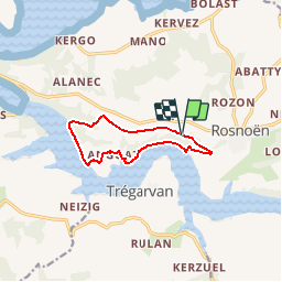
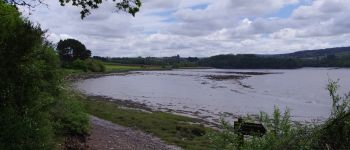
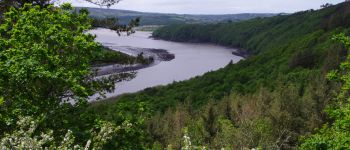
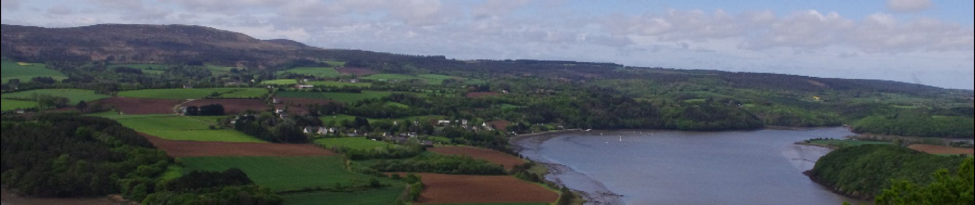
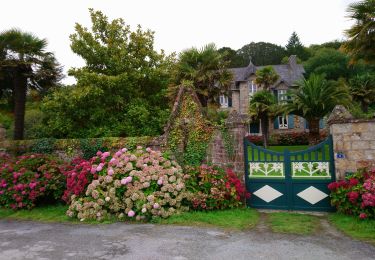
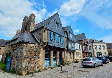
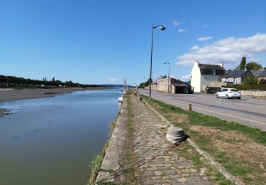
Tour Wandern von 8,6 km verfügbar auf Bretagne, Finistère, Rosnoën. Diese Tour wird von neoroll44 vorgeschlagen.
Beschreibung
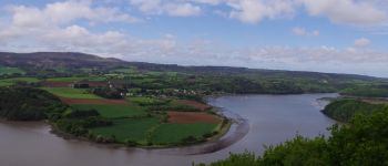
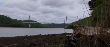
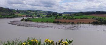
Les bords de l'Aulne près de Rosnoën. De belles vues sur l'Aulne. Des parties difficiles le long de la berge et en forêt. Des parties impraticables à marée haute. Attention aux horaires et coefficients de marée.
Ort
Land:
France
Region :
Bretagne
Abteilung/Provinz :
Finistère
Kommune :
Rosnoën
Standort:
Unknown
Gehen Sie:(Dec)
Gehen Sie:(UTM)
409932 ; 5346230 (30U) N.
Kommentare
Touren in der Umgebung
![Tour Wandern Le Faou - GR34 Le Faou -- Rangoulic - Photo](https://media.geolcdn.com/t/375/260/18c0dca4-5c39-42e4-8316-bd6c3dd72709.jpg&format=jpg&maxdim=2)
![Wandern Wandern](https://static1.geolcdn.com/sitytour/trail-icons/101.png)
GR34 Le Faou -- Rangoulic
Wandern
Sehr schwierig
Le Faou,
Bretagne,
Finistère,
France
![](/images/other/stat-length.png)
18,3 km | 25 km-effort
5h 38min
![](https://static1.geolcdn.com/siteimages/upload/files/16400158638029165_repeat_loop_refresh_sync_direction_icon.png)
Nein
![Tour Wandern Landévennec - Landévennec - boucles locales et GR34 - 13.8km 250m 4h10 (35mn) - 2019 09 12 - Photo](https://media.geolcdn.com/t/375/260/ed0a847b-b2f3-4f8e-b6b5-8e6353637e62.jpg&format=jpg&maxdim=2)
![Wandern Wandern](https://static1.geolcdn.com/sitytour/trail-icons/101.png)
Landévennec - boucles locales et GR34 - 13.8km 250m 4h10 (35mn) - 2019 09 12
Wandern
Einfach
Landévennec,
Bretagne,
Finistère,
France
![](/images/other/stat-length.png)
13,8 km | 17,2 km-effort
4h 10min
![](https://static1.geolcdn.com/siteimages/upload/files/16400158638029165_repeat_loop_refresh_sync_direction_icon.png)
Ja
![Tour Wandern Trégarvan - Menez Hom_10,3km_Trace GPS - Photo](https://media.geolcdn.com/t/375/260/ext.jpg?maxdim=2&url=https%3A%2F%2Fstatic1.geolcdn.com%2Fsiteimages%2Fupload%2Ffiles%2F1553511878bg_sport_marche.png)
![Wandern Wandern](https://static1.geolcdn.com/sitytour/trail-icons/101.png)
Menez Hom_10,3km_Trace GPS
Wandern
Medium
(1)
Trégarvan,
Bretagne,
Finistère,
France
![](/images/other/stat-length.png)
10,2 km | 14 km-effort
3h 0min
![](https://static1.geolcdn.com/siteimages/upload/files/16400158638029165_repeat_loop_refresh_sync_direction_icon.png)
Ja
![Tour Wandern Trégarvan - TREGARVAN_6,7km_Trace GPS - Photo](https://media.geolcdn.com/t/375/260/ext.jpg?maxdim=2&url=https%3A%2F%2Fstatic1.geolcdn.com%2Fsiteimages%2Fupload%2Ffiles%2F1553511878bg_sport_marche.png)
![Wandern Wandern](https://static1.geolcdn.com/sitytour/trail-icons/101.png)
TREGARVAN_6,7km_Trace GPS
Wandern
Einfach
(1)
Trégarvan,
Bretagne,
Finistère,
France
![](/images/other/stat-length.png)
6,7 km | 8,4 km-effort
1h 50min
![](https://static1.geolcdn.com/siteimages/upload/files/16400158638029165_repeat_loop_refresh_sync_direction_icon.png)
Ja
![Tour Wandern Le Faou - Visite express du centre historique de Le Faou - Photo](https://media.geolcdn.com/t/375/260/904406ee-aa12-46c4-a3f2-893fdc7c38f2.jpg&format=jpg&maxdim=2)
![Wandern Wandern](https://static1.geolcdn.com/sitytour/trail-icons/101.png)
Visite express du centre historique de Le Faou
Wandern
Sehr leicht
Le Faou,
Bretagne,
Finistère,
France
![](/images/other/stat-length.png)
2,3 km | 2,5 km-effort
33min
![](https://static1.geolcdn.com/siteimages/upload/files/16400158638029165_repeat_loop_refresh_sync_direction_icon.png)
Ja
![Tour Wandern Landévennec - LANDÉVENNEC - Photo](https://media.geolcdn.com/t/375/260/3aa9913a-4da7-4716-a24d-72b5f897ad92.jpg&format=jpg&maxdim=2)
![Wandern Wandern](https://static1.geolcdn.com/sitytour/trail-icons/101.png)
LANDÉVENNEC
Wandern
Schwierig
Landévennec,
Bretagne,
Finistère,
France
![](/images/other/stat-length.png)
19,4 km | 25 km-effort
4h 41min
![](https://static1.geolcdn.com/siteimages/upload/files/16400158638029165_repeat_loop_refresh_sync_direction_icon.png)
Nein
![Tour Wandern Le Faou - GRP_Crozon_CB_01_Le-Faou_Argol_20200919 - Photo](https://media.geolcdn.com/t/375/260/fbd34cbb-bebb-46b9-8e23-76c365c1b8c8.jpg&format=jpg&maxdim=2)
![Wandern Wandern](https://static1.geolcdn.com/sitytour/trail-icons/101.png)
GRP_Crozon_CB_01_Le-Faou_Argol_20200919
Wandern
Medium
Le Faou,
Bretagne,
Finistère,
France
![](/images/other/stat-length.png)
15,9 km | 21 km-effort
4h 31min
![](https://static1.geolcdn.com/siteimages/upload/files/16400158638029165_repeat_loop_refresh_sync_direction_icon.png)
Nein
![Tour Wandern Le Faou - La randonnée du Faou - Photo](https://media.geolcdn.com/t/375/260/52fdc54d-e20e-467f-ae3e-b4bd86da525e.jpg&format=jpg&maxdim=2)
![Wandern Wandern](https://static1.geolcdn.com/sitytour/trail-icons/101.png)
La randonnée du Faou
Wandern
Medium
Le Faou,
Bretagne,
Finistère,
France
![](/images/other/stat-length.png)
9,4 km | 11,6 km-effort
3h 37min
![](https://static1.geolcdn.com/siteimages/upload/files/16400158638029165_repeat_loop_refresh_sync_direction_icon.png)
Ja
![Tour Zu Fuß Saint-Nic - Circuit du Menez-Hom - Photo](https://media.geolcdn.com/t/375/260/760775ab-c8f5-4115-9a49-824ff941c9f9.jpeg&format=jpg&maxdim=2)
![Zu Fuß Zu Fuß](https://static1.geolcdn.com/sitytour/trail-icons/100.png)
Circuit du Menez-Hom
Zu Fuß
Einfach
Saint-Nic,
Bretagne,
Finistère,
France
![](/images/other/stat-length.png)
4,8 km | 6 km-effort
1h 22min
![](https://static1.geolcdn.com/siteimages/upload/files/16400158638029165_repeat_loop_refresh_sync_direction_icon.png)
Nein