![](/images/other/stat-length.png)
![Tour Wandern Remauville - de Remauville à la vallée du Lunain - Photo](https://media.geolcdn.com/t/1900/400/ext.pjpeg?maxdim=2&url=https%3A%2F%2Fstatic1.geolcdn.com%2Fsiteimages%2Fupload%2Ffiles%2F1553511878bg_sport_marche.png)
de Remauville à la vallée du Lunain
micheljannot
Benutzer
![Länge](/images/other/stat-length.png)
Länge
16,8 km
![Maximale Höhe](https://static1.geolcdn.com/siteimages/upload/files/1508320355ic_sort_altitude_max_24dp.png)
Maximale Höhe
133 m
![Positive Höhendifferenz](https://static1.geolcdn.com/siteimages/upload/files/1508320355ic_sort_den_pos_24dp.png)
Positive Höhendifferenz
174 m
![Km-Effort](/images/other/stat-length.png)
Km-Effort
19,1 km
![Min. Höhe](https://static1.geolcdn.com/siteimages/upload/files/1508320355ic_sort_altitude_min_24dp.png)
Min. Höhe
78 m
![Negative Höhendifferenz](https://static1.geolcdn.com/siteimages/upload/files/1508320355ic_sort_den_neg_24dp.png)
Negative Höhendifferenz
174 m
![Boucle](https://static1.geolcdn.com/siteimages/upload/files/16400158638029165_repeat_loop_refresh_sync_direction_icon.png)
Boucle
Ja
Erstellungsdatum :
2016-09-08 00:00:00.0
Letzte Änderung :
2016-09-08 00:00:00.0
![Wandern](https://static1.geolcdn.com/sitytour/trail-icons/101.png)
4h12
Schwierigkeit : Einfach
![Scannen Sie diesen QR-Code, um die Tour in der SityTrail-Anwendung zu öffnen](https://capi.geolives.com/qq0zvz2zws4bq2lad0pu/sitytour/trails/554701/qr.png?size=200)
Kostenlosegpshiking-Anwendung
Über SityTrail
Tour Wandern von 16,8 km verfügbar auf Île-de-France, Seine-et-Marne, Remauville. Diese Tour wird von micheljannot vorgeschlagen.
Beschreibung
C'est une belle randonnée alliant plateau et vallée. Elle a été utilisée pour la Balade gourmande du 12 juin 2016
Ort
Land:
France
Region :
Île-de-France
Abteilung/Provinz :
Seine-et-Marne
Kommune :
Remauville
Standort:
Unknown
Gehen Sie:(Dec)
Gehen Sie:(UTM)
486978 ; 5339834 (31U) N.
Kommentare
Touren in der Umgebung
![Tour Zu Fuß Remauville - L'Etre supreme en terre romaine - Photo](https://media.geolcdn.com/t/375/260/f276cc78-73d0-49b2-bef6-7b0f7c19a230.jpeg&format=jpg&maxdim=2)
![Zu Fuß Zu Fuß](https://static1.geolcdn.com/sitytour/trail-icons/100.png)
L'Etre supreme en terre romaine
Zu Fuß
Medium
Remauville,
Île-de-France,
Seine-et-Marne,
France
![](/images/other/stat-length.png)
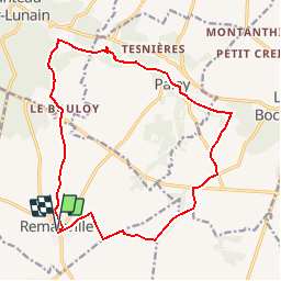
18,1 km | 20 km-effort
4h 34min
![](https://static1.geolcdn.com/siteimages/upload/files/16400158638029165_repeat_loop_refresh_sync_direction_icon.png)
Ja
![Tour Zu Fuß Paley - Le](https://media.geolcdn.com/t/375/260/c816f8c5-1b7e-467a-b427-7ddd8748fec3.jpeg&format=jpg&maxdim=2)
![Zu Fuß Zu Fuß](https://static1.geolcdn.com/sitytour/trail-icons/100.png)
Le "père" Trembleau
Zu Fuß
Einfach
Paley,
Île-de-France,
Seine-et-Marne,
France
![](/images/other/stat-length.png)
15,8 km | 17,9 km-effort
4h 3min
![](https://static1.geolcdn.com/siteimages/upload/files/16400158638029165_repeat_loop_refresh_sync_direction_icon.png)
Ja
![Tour sport Paley - Rando Dominique - Photo](https://media.geolcdn.com/t/375/260/ext.jpg?maxdim=2&url=https%3A%2F%2Fsecurestorage.geolives.com%2Fsitytour%2Ftrail-bg%2Fdefault.jpg)
Rando Dominique
sport
Sehr leicht
Paley,
Île-de-France,
Seine-et-Marne,
France
![](/images/other/stat-length.png)
10,9 km | 12,5 km-effort
Unbekannt
![](https://static1.geolcdn.com/siteimages/upload/files/16400158638029165_repeat_loop_refresh_sync_direction_icon.png)
Nein
![Tour Wandern Paley - Paley - Photo](https://media.geolcdn.com/t/375/260/2649a49e-4570-4acb-b4d0-1f4d13254a9b.jpg&format=jpg&maxdim=2)
![Wandern Wandern](https://static1.geolcdn.com/sitytour/trail-icons/101.png)
Paley
Wandern
Sehr leicht
Paley,
Île-de-France,
Seine-et-Marne,
France
![](/images/other/stat-length.png)
17,3 km | 21 km-effort
3h 55min
![](https://static1.geolcdn.com/siteimages/upload/files/16400158638029165_repeat_loop_refresh_sync_direction_icon.png)
Ja
![Tour Wandern Égreville - egrevilleSR061019 - Photo](https://media.geolcdn.com/t/375/260/ext.jpg?maxdim=2&url=https%3A%2F%2Fstatic1.geolcdn.com%2Fsiteimages%2Fupload%2Ffiles%2F1553511878bg_sport_marche.png)
![Wandern Wandern](https://static1.geolcdn.com/sitytour/trail-icons/101.png)
egrevilleSR061019
Wandern
Einfach
Égreville,
Île-de-France,
Seine-et-Marne,
France
![](/images/other/stat-length.png)
20 km | 22 km-effort
4h 33min
![](https://static1.geolcdn.com/siteimages/upload/files/16400158638029165_repeat_loop_refresh_sync_direction_icon.png)
Ja
![Tour Andere Aktivitäten Poligny - J2-v2-Bouchereau/Ury - Photo](https://media.geolcdn.com/t/375/260/ext.jpg?maxdim=2&url=https%3A%2F%2Fstatic1.geolcdn.com%2Fsiteimages%2Fupload%2Ffiles%2F1545311037marcheuse_200dpi.jpg)
![Andere Aktivitäten Andere Aktivitäten](https://static1.geolcdn.com/sitytour/trail-icons/900.png)
J2-v2-Bouchereau/Ury
Andere Aktivitäten
Sehr leicht
Poligny,
Île-de-France,
Seine-et-Marne,
France
![](/images/other/stat-length.png)
31 km | 35 km-effort
5h 0min
![](https://static1.geolcdn.com/siteimages/upload/files/16400158638029165_repeat_loop_refresh_sync_direction_icon.png)
Nein
![Tour Andere Aktivitäten Poligny - J3-Bouchereau/Ury - Photo](https://media.geolcdn.com/t/375/260/ext.jpg?maxdim=2&url=https%3A%2F%2Fstatic1.geolcdn.com%2Fsiteimages%2Fupload%2Ffiles%2F1545311037marcheuse_200dpi.jpg)
![Andere Aktivitäten Andere Aktivitäten](https://static1.geolcdn.com/sitytour/trail-icons/900.png)
J3-Bouchereau/Ury
Andere Aktivitäten
Medium
Poligny,
Île-de-France,
Seine-et-Marne,
France
![](/images/other/stat-length.png)
34 km | 39 km-effort
3h 0min
![](https://static1.geolcdn.com/siteimages/upload/files/16400158638029165_repeat_loop_refresh_sync_direction_icon.png)
Nein
![Tour Wandern Paley - lunain historique - Photo](https://media.geolcdn.com/t/375/260/ext.jpg?maxdim=2&url=https%3A%2F%2Fstatic1.geolcdn.com%2Fsiteimages%2Fupload%2Ffiles%2F1553511878bg_sport_marche.png)
![Wandern Wandern](https://static1.geolcdn.com/sitytour/trail-icons/101.png)
lunain historique
Wandern
Einfach
Paley,
Île-de-France,
Seine-et-Marne,
France
![](/images/other/stat-length.png)
16 km | 18,9 km-effort
4h 10min
![](https://static1.geolcdn.com/siteimages/upload/files/16400158638029165_repeat_loop_refresh_sync_direction_icon.png)
Ja
![Tour Wandern Paley - Paley - Photo](https://media.geolcdn.com/t/375/260/ext.jpg?maxdim=2&url=https%3A%2F%2Fstatic1.geolcdn.com%2Fsiteimages%2Fupload%2Ffiles%2F1553511878bg_sport_marche.png)
![Wandern Wandern](https://static1.geolcdn.com/sitytour/trail-icons/101.png)
Paley
Wandern
Einfach
Paley,
Île-de-France,
Seine-et-Marne,
France
![](/images/other/stat-length.png)
17,4 km | 19,4 km-effort
4h 22min
![](https://static1.geolcdn.com/siteimages/upload/files/16400158638029165_repeat_loop_refresh_sync_direction_icon.png)
Ja