![](/images/other/stat-length.png)
![Tour Wandern Bioussac - Bioussac_Boulogne - Photo](https://media.geolcdn.com/t/1900/400/ext.pjpeg?maxdim=2&url=https%3A%2F%2Fservices.sitytrail.com%2FGeolivesWS%2FDownloadMedia.ashx%3FTrailID%3D554291%26Media%3Df90753df-7d12-4ac6-9774-48572749661b.jpg)
Bioussac_Boulogne
neoroll44
Benutzer
![Länge](/images/other/stat-length.png)
Länge
5,2 km
![Maximale Höhe](https://static1.geolcdn.com/siteimages/upload/files/1508320355ic_sort_altitude_max_24dp.png)
Maximale Höhe
155 m
![Positive Höhendifferenz](https://static1.geolcdn.com/siteimages/upload/files/1508320355ic_sort_den_pos_24dp.png)
Positive Höhendifferenz
55 m
![Km-Effort](/images/other/stat-length.png)
Km-Effort
5,9 km
![Min. Höhe](https://static1.geolcdn.com/siteimages/upload/files/1508320355ic_sort_altitude_min_24dp.png)
Min. Höhe
112 m
![Negative Höhendifferenz](https://static1.geolcdn.com/siteimages/upload/files/1508320355ic_sort_den_neg_24dp.png)
Negative Höhendifferenz
53 m
![Boucle](https://static1.geolcdn.com/siteimages/upload/files/16400158638029165_repeat_loop_refresh_sync_direction_icon.png)
Boucle
Ja
Erstellungsdatum :
2016-04-20 00:00:00.0
Letzte Änderung :
2016-04-20 00:00:00.0
![Wandern](https://static1.geolcdn.com/sitytour/trail-icons/101.png)
1h20
Schwierigkeit : Einfach
![Scannen Sie diesen QR-Code, um die Tour in der SityTrail-Anwendung zu öffnen](https://capi.geolives.com/qq0zvz2zws4bq2lad0pu/sitytour/trails/554291/qr.png?size=200)
Kostenlosegpshiking-Anwendung
Über SityTrail
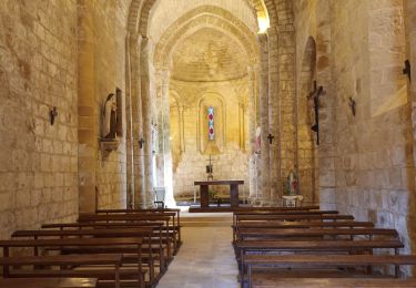
Tour Wandern von 5,2 km verfügbar auf Neu-Aquitanien, Charente, Bioussac. Diese Tour wird von neoroll44 vorgeschlagen.
Beschreibung
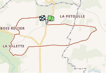
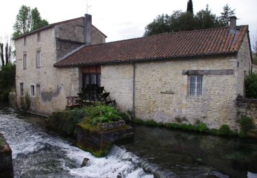
Circuit du bois de Boulogne (jaune). Depuis la route de la Betoulle, point de vue sur la vallée de la Lizonne, passage à la source de la Valette.
Ort
Land:
France
Region :
Neu-Aquitanien
Abteilung/Provinz :
Charente
Kommune :
Bioussac
Standort:
Unknown
Gehen Sie:(Dec)
Gehen Sie:(UTM)
289365 ; 5102900 (31T) N.
Kommentare
Touren in der Umgebung
![Tour Hybrid-Bike Condac - rejellant chassane - Photo](https://media.geolcdn.com/t/375/260/f941dbf9-6f50-4e7d-8c40-12817a339d98.jpg&format=jpg&maxdim=2)
![Hybrid-Bike Hybrid-Bike](https://static1.geolcdn.com/sitytour/trail-icons/203.png)
rejellant chassane
Hybrid-Bike
Einfach
Condac,
Neu-Aquitanien,
Charente,
France
![](/images/other/stat-length.png)
17,5 km | 19,6 km-effort
5h 11min
![](https://static1.geolcdn.com/siteimages/upload/files/16400158638029165_repeat_loop_refresh_sync_direction_icon.png)
Nein
![Tour Wandern Condac - Condac - Photo](https://media.geolcdn.com/t/375/260/ext.jpg?maxdim=2&url=https%3A%2F%2Fservices.sitytrail.com%2FGeolivesWS%2FDownloadMedia.ashx%3FTrailID%3D556317%26Media%3Ddcadb249-373c-4f07-b689-15b2cfca5ca5.JPG)
![Wandern Wandern](https://static1.geolcdn.com/sitytour/trail-icons/101.png)
![Tour Wandern Condac - Condac_Bioussac_Barro - Photo](https://media.geolcdn.com/t/375/260/ext.jpg?maxdim=2&url=https%3A%2F%2Fservices.sitytrail.com%2FGeolivesWS%2FDownloadMedia.ashx%3FTrailID%3D554281%26Media%3Dad2440e1-83f4-4ca4-9ca5-3c359047fce4.JPG)
![Wandern Wandern](https://static1.geolcdn.com/sitytour/trail-icons/101.png)
Condac_Bioussac_Barro
Wandern
Medium
Condac,
Neu-Aquitanien,
Charente,
France
![](/images/other/stat-length.png)
26 km | 31 km-effort
6h 40min
![](https://static1.geolcdn.com/siteimages/upload/files/16400158638029165_repeat_loop_refresh_sync_direction_icon.png)
Ja
![Tour Wandern Taizé-Aizie - Taizé-Aizie - Photo](https://media.geolcdn.com/t/375/260/ext.jpg?maxdim=2&url=https%3A%2F%2Fservices.sitytrail.com%2FGeolivesWS%2FDownloadMedia.ashx%3FTrailID%3D555629%26Media%3De6af0e7d-f7c4-404c-8887-86491915c595.jpg)
![Wandern Wandern](https://static1.geolcdn.com/sitytour/trail-icons/101.png)
Taizé-Aizie
Wandern
Medium
Taizé-Aizie,
Neu-Aquitanien,
Charente,
France
![](/images/other/stat-length.png)
14,7 km | 17 km-effort
4h 0min
![](https://static1.geolcdn.com/siteimages/upload/files/16400158638029165_repeat_loop_refresh_sync_direction_icon.png)
Ja
![Tour Wandern Barro - Barro - Photo](https://media.geolcdn.com/t/375/260/ext.jpg?maxdim=2&url=https%3A%2F%2Fstatic1.geolcdn.com%2Fsiteimages%2Fupload%2Ffiles%2F1553511878bg_sport_marche.png)
![Wandern Wandern](https://static1.geolcdn.com/sitytour/trail-icons/101.png)
![Tour Wandern Bioussac - Bioussac_Lavoirs - Photo](https://media.geolcdn.com/t/375/260/ext.jpg?maxdim=2&url=https%3A%2F%2Fstatic1.geolcdn.com%2Fsiteimages%2Fupload%2Ffiles%2F1553511878bg_sport_marche.png)
![Wandern Wandern](https://static1.geolcdn.com/sitytour/trail-icons/101.png)
Bioussac_Lavoirs
Wandern
Medium
Bioussac,
Neu-Aquitanien,
Charente,
France
![](/images/other/stat-length.png)
10,8 km | 12,5 km-effort
3h 0min
![](https://static1.geolcdn.com/siteimages/upload/files/16400158638029165_repeat_loop_refresh_sync_direction_icon.png)
Ja
![Tour Wandern Lizant - lizan - Photo](https://media.geolcdn.com/t/375/260/ext.jpg?maxdim=2&url=https%3A%2F%2Fstatic1.geolcdn.com%2Fsiteimages%2Fupload%2Ffiles%2F1553511878bg_sport_marche.png)
![Wandern Wandern](https://static1.geolcdn.com/sitytour/trail-icons/101.png)
![Tour Wandern Lizant - cornac/cibiou - Photo](https://media.geolcdn.com/t/375/260/ext.jpg?maxdim=2&url=https%3A%2F%2Fstatic1.geolcdn.com%2Fsiteimages%2Fupload%2Ffiles%2F1553511878bg_sport_marche.png)
![Wandern Wandern](https://static1.geolcdn.com/sitytour/trail-icons/101.png)
cornac/cibiou
Wandern
Medium
Lizant,
Neu-Aquitanien,
Vienne,
France
![](/images/other/stat-length.png)
13 km | 15,4 km-effort
3h 22min
![](https://static1.geolcdn.com/siteimages/upload/files/16400158638029165_repeat_loop_refresh_sync_direction_icon.png)
Ja
![Tour Wandern Lizant - Charente 2019-2 - Photo](https://media.geolcdn.com/t/375/260/ext.jpg?maxdim=2&url=https%3A%2F%2Fstatic1.geolcdn.com%2Fsiteimages%2Fupload%2Ffiles%2F1553511878bg_sport_marche.png)
![Wandern Wandern](https://static1.geolcdn.com/sitytour/trail-icons/101.png)
Charente 2019-2
Wandern
Einfach
Lizant,
Neu-Aquitanien,
Vienne,
France
![](/images/other/stat-length.png)
12,6 km | 15 km-effort
3h 14min
![](https://static1.geolcdn.com/siteimages/upload/files/16400158638029165_repeat_loop_refresh_sync_direction_icon.png)
Nein