![](/images/other/stat-length.png)
![Tour Wandern Vauvert - Vauvert lesCostieres - Photo](https://media.geolcdn.com/t/1900/400/ext.pjpeg?maxdim=2&url=https%3A%2F%2Fstatic1.geolcdn.com%2Fsiteimages%2Fupload%2Ffiles%2F1553511878bg_sport_marche.png)
Vauvert lesCostieres
grageot
Benutzer
![Länge](/images/other/stat-length.png)
Länge
18 km
![Maximale Höhe](https://static1.geolcdn.com/siteimages/upload/files/1508320355ic_sort_altitude_max_24dp.png)
Maximale Höhe
110 m
![Positive Höhendifferenz](https://static1.geolcdn.com/siteimages/upload/files/1508320355ic_sort_den_pos_24dp.png)
Positive Höhendifferenz
250 m
![Km-Effort](/images/other/stat-length.png)
Km-Effort
21 km
![Min. Höhe](https://static1.geolcdn.com/siteimages/upload/files/1508320355ic_sort_altitude_min_24dp.png)
Min. Höhe
19 m
![Negative Höhendifferenz](https://static1.geolcdn.com/siteimages/upload/files/1508320355ic_sort_den_neg_24dp.png)
Negative Höhendifferenz
251 m
![Boucle](https://static1.geolcdn.com/siteimages/upload/files/16400158638029165_repeat_loop_refresh_sync_direction_icon.png)
Boucle
Ja
Erstellungsdatum :
2016-04-14 00:00:00.0
Letzte Änderung :
2016-04-14 00:00:00.0
![Wandern](https://static1.geolcdn.com/sitytour/trail-icons/101.png)
4h27
Schwierigkeit : Einfach
![Scannen Sie diesen QR-Code, um die Tour in der SityTrail-Anwendung zu öffnen](https://capi.geolives.com/qq0zvz2zws4bq2lad0pu/sitytour/trails/553651/qr.png?size=200)
Kostenlosegpshiking-Anwendung
Über SityTrail
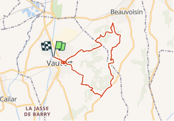
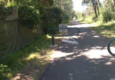
Tour Wandern von 18 km verfügbar auf Okzitanien, Gard, Vauvert. Diese Tour wird von grageot vorgeschlagen.
Beschreibung
Ballade sans difficulté dans les bois et vallons des Costières : à voir les salines demander explications, une petite visite dans le vieux Vauveert pour la fin avec montée au Castellas
Ort
Land:
France
Region :
Okzitanien
Abteilung/Provinz :
Gard
Kommune :
Vauvert
Standort:
Unknown
Gehen Sie:(Dec)
Gehen Sie:(UTM)
602453 ; 4838852 (31T) N.
Kommentare
Touren in der Umgebung
![Tour Wandern Vauvert - Vauvert - Villetelle - Photo](https://media.geolcdn.com/t/375/260/ext.jpg?maxdim=2&url=https%3A%2F%2Fservices.sitytrail.com%2FGeolivesWS%2FDownloadMedia.ashx%3FTrailID%3D182328%26Media%3D20130331150712.jpeg)
![Wandern Wandern](https://static1.geolcdn.com/sitytour/trail-icons/101.png)
Vauvert - Villetelle
Wandern
Medium
(1)
Vauvert,
Okzitanien,
Gard,
France
![](/images/other/stat-length.png)
22 km | 23 km-effort
6h 51min
![](https://static1.geolcdn.com/siteimages/upload/files/16400158638029165_repeat_loop_refresh_sync_direction_icon.png)
Nein
![Tour Wandern Vauvert - Vauvert Les escaliers de verre - Photo](https://media.geolcdn.com/t/375/260/ext.jpg?maxdim=2&url=https%3A%2F%2Fstatic1.geolcdn.com%2Fsiteimages%2Fupload%2Ffiles%2F1553511878bg_sport_marche.png)
![Wandern Wandern](https://static1.geolcdn.com/sitytour/trail-icons/101.png)
Vauvert Les escaliers de verre
Wandern
Einfach
(1)
Vauvert,
Okzitanien,
Gard,
France
![](/images/other/stat-length.png)
7,1 km | 8,4 km-effort
1h 37min
![](https://static1.geolcdn.com/siteimages/upload/files/16400158638029165_repeat_loop_refresh_sync_direction_icon.png)
Ja
![Tour Wandern Le Cailar - cailar-costieres-camargues - Photo](https://media.geolcdn.com/t/375/260/ext.jpg?maxdim=2&url=https%3A%2F%2Fmedia.geolcdn.com%2Ff%2Fa9e966b9-9cc8-45d5-8aba-8fc28d450985.jpg)
![Wandern Wandern](https://static1.geolcdn.com/sitytour/trail-icons/101.png)
cailar-costieres-camargues
Wandern
Medium
Le Cailar,
Okzitanien,
Gard,
France
![](/images/other/stat-length.png)
20 km | 22 km-effort
4h 0min
![](https://static1.geolcdn.com/siteimages/upload/files/16400158638029165_repeat_loop_refresh_sync_direction_icon.png)
Ja
![Tour Hybrid-Bike Vauvert - 2020-01-29_15h48m07_10922156-track-1580309276-692 - Photo](https://media.geolcdn.com/t/375/260/ext.jpg?maxdim=2&url=https%3A%2F%2Fstatic1.geolcdn.com%2Fsiteimages%2Fupload%2Ffiles%2F1524743154velo.jpg)
![Hybrid-Bike Hybrid-Bike](https://static1.geolcdn.com/sitytour/trail-icons/203.png)
2020-01-29_15h48m07_10922156-track-1580309276-692
Hybrid-Bike
Sehr leicht
(1)
Vauvert,
Okzitanien,
Gard,
France
![](/images/other/stat-length.png)
50 km | 52 km-effort
Unbekannt
![](https://static1.geolcdn.com/siteimages/upload/files/16400158638029165_repeat_loop_refresh_sync_direction_icon.png)
Ja
![Tour Wandern Beauvoisin - 30 BEAUVOISIN, promenade dans les Costières de Nîmes, Entre Pinèdes, vignes, mas et vergers - Photo](https://media.geolcdn.com/t/375/260/ext.jpg?maxdim=2&url=https%3A%2F%2Fservices.sitytrail.com%2FGeolivesWS%2FDownloadMedia.ashx%3FTrailID%3D569988%26Media%3D20160516110625.jpg)
![Wandern Wandern](https://static1.geolcdn.com/sitytour/trail-icons/101.png)
30 BEAUVOISIN, promenade dans les Costières de Nîmes, Entre Pinèdes, vignes, ...
Wandern
Medium
Beauvoisin,
Okzitanien,
Gard,
France
![](/images/other/stat-length.png)
22 km | 25 km-effort
3h 51min
![](https://static1.geolcdn.com/siteimages/upload/files/16400158638029165_repeat_loop_refresh_sync_direction_icon.png)
Ja
![Tour Wandern Vauvert - 30 VAUVERT - GR653 - chemin d'Arles - FRANQUEVAUX - d'un canal a l'autre - GALLICIAN - ch. des Coquillons - Photo](https://media.geolcdn.com/t/375/260/ext.jpg?maxdim=2&url=https%3A%2F%2Fservices.sitytrail.com%2FGeolivesWS%2FDownloadMedia.ashx%3FTrailID%3D459354%26Media%3D20150815150702.jpg)
![Wandern Wandern](https://static1.geolcdn.com/sitytour/trail-icons/101.png)
30 VAUVERT - GR653 - chemin d'Arles - FRANQUEVAUX - d'un canal a l'autre - GA...
Wandern
Schwierig
Vauvert,
Okzitanien,
Gard,
France
![](/images/other/stat-length.png)
28 km | 31 km-effort
5h 1min
![](https://static1.geolcdn.com/siteimages/upload/files/16400158638029165_repeat_loop_refresh_sync_direction_icon.png)
Ja
![Tour Rennrad Codognan - 34 Sommières vv extension voir - Photo](https://media.geolcdn.com/t/375/260/ext.jpg?maxdim=2&url=https%3A%2F%2Fmedia.geolcdn.com%2Ff%2F2c59a0cb-df5b-44c4-871f-8d9e21a6b286.jpg)
![Rennrad Rennrad](https://static1.geolcdn.com/sitytour/trail-icons/201.png)
34 Sommières vv extension voir
Rennrad
Medium
Codognan,
Okzitanien,
Gard,
France
![](/images/other/stat-length.png)
57 km | 64 km-effort
3h 36min
![](https://static1.geolcdn.com/siteimages/upload/files/16400158638029165_repeat_loop_refresh_sync_direction_icon.png)
Nein
![Tour Wandern Vauvert - vauvert Est - Photo](https://media.geolcdn.com/t/375/260/ext.jpg?maxdim=2&url=https%3A%2F%2Fstatic1.geolcdn.com%2Fsiteimages%2Fupload%2Ffiles%2F1553511878bg_sport_marche.png)
![Wandern Wandern](https://static1.geolcdn.com/sitytour/trail-icons/101.png)
![Tour Wandern Le Cailar - Le Cailar - Photo](https://media.geolcdn.com/t/375/260/ext.jpg?maxdim=2&url=https%3A%2F%2Fstatic1.geolcdn.com%2Fsiteimages%2Fupload%2Ffiles%2F1553511878bg_sport_marche.png)
![Wandern Wandern](https://static1.geolcdn.com/sitytour/trail-icons/101.png)
Le Cailar
Wandern
Sehr schwierig
Le Cailar,
Okzitanien,
Gard,
France
![](/images/other/stat-length.png)
15,6 km | 16,8 km-effort
4h 3min
![](https://static1.geolcdn.com/siteimages/upload/files/16400158638029165_repeat_loop_refresh_sync_direction_icon.png)
Ja