![](/images/other/stat-length.png)
![Tour Laufen Entrepierres - Crète de Vaumuse par le Champ de la Plate - Photo](https://media.geolcdn.com/t/1900/400/ext.pjpeg?maxdim=2&url=https%3A%2F%2Fservices.sitytrail.com%2FGeolivesWS%2FDownloadMedia.ashx%3FTrailID%3D551894%26Media%3Dfix__20160410110503.jpg)
Crète de Vaumuse par le Champ de la Plate
phd04
Benutzer
![Länge](/images/other/stat-length.png)
![Maximale Höhe](https://static1.geolcdn.com/siteimages/upload/files/1508320355ic_sort_altitude_max_24dp.png)
![Positive Höhendifferenz](https://static1.geolcdn.com/siteimages/upload/files/1508320355ic_sort_den_pos_24dp.png)
![Km-Effort](/images/other/stat-length.png)
![Min. Höhe](https://static1.geolcdn.com/siteimages/upload/files/1508320355ic_sort_altitude_min_24dp.png)
![Negative Höhendifferenz](https://static1.geolcdn.com/siteimages/upload/files/1508320355ic_sort_den_neg_24dp.png)
![Boucle](https://static1.geolcdn.com/siteimages/upload/files/16400158638029165_repeat_loop_refresh_sync_direction_icon.png)
![Laufen](https://static1.geolcdn.com/sitytour/trail-icons/103.png)
4h09
Schwierigkeit : Sehr schwierig
![Scannen Sie diesen QR-Code, um die Tour in der SityTrail-Anwendung zu öffnen](https://capi.geolives.com/qq0zvz2zws4bq2lad0pu/sitytour/trails/551894/qr.png?size=200)
Kostenlosegpshiking-Anwendung
Über SityTrail
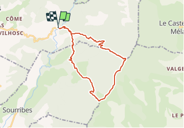
Tour Laufen von 16,5 km verfügbar auf Provence-Alpes-Côte d'Azur, Alpes-de-Haute-Provence, Entrepierres. Diese Tour wird von phd04 vorgeschlagen.
Beschreibung
Attention à ne pas louper l'embranchement pour redescendre sur St Symphorien.
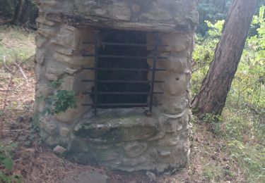
Après être passer en surplomb de la Chapelle St Joseph vous arrivez à une croix. Passer cette croix et faire 2 à 300 m et prendre à droite. Le début du sentier est matérialisé par des tas de pierres et 2 piquets de cloture
Ort
Kommentare
Touren in der Umgebung
![Tour Wandern Saint-Geniez - S GENIEZ . ABROS . LA FOREST . COL DE MOUNIS . O L M - Photo](https://media.geolcdn.com/t/375/260/fe9f057e-508d-4bc4-89fa-aff1c37055dd.jpg&format=jpg&maxdim=2)
![Wandern Wandern](https://static1.geolcdn.com/sitytour/trail-icons/101.png)
Wandern
![](/images/other/stat-length.png)
![](https://static1.geolcdn.com/siteimages/upload/files/16400158638029165_repeat_loop_refresh_sync_direction_icon.png)
![Tour Wandern Entrepierres - SAINT GENIEZ . LE MOURRE DE GACHE PAR LA FONT DE MEGE N - Photo](https://media.geolcdn.com/t/375/260/5d853fdd-5713-4858-a535-57b1bf5db08d.jpg&format=jpg&maxdim=2)
![Wandern Wandern](https://static1.geolcdn.com/sitytour/trail-icons/101.png)
Wandern
![](/images/other/stat-length.png)
![](https://static1.geolcdn.com/siteimages/upload/files/16400158638029165_repeat_loop_refresh_sync_direction_icon.png)
![Tour Wandern Saint-Geniez - 28-10-2022 Tour du Dromon - Photo](https://media.geolcdn.com/t/375/260/143c8162-2f8c-416a-a5c9-32f364c7a4e0.jpg&format=jpg&maxdim=2)
![Wandern Wandern](https://static1.geolcdn.com/sitytour/trail-icons/101.png)
Wandern
![](/images/other/stat-length.png)
![](https://static1.geolcdn.com/siteimages/upload/files/16400158638029165_repeat_loop_refresh_sync_direction_icon.png)
![Tour Wandern Saint-Geniez - SAINT GENIEZ . CHAPELLE DE DROMOND . ABROS O L M - Photo](https://media.geolcdn.com/t/375/260/ba139fff-eae1-474f-84ee-ab398a11d5a4.jpg&format=jpg&maxdim=2)
![Wandern Wandern](https://static1.geolcdn.com/sitytour/trail-icons/101.png)
Wandern
![](/images/other/stat-length.png)
![](https://static1.geolcdn.com/siteimages/upload/files/16400158638029165_repeat_loop_refresh_sync_direction_icon.png)
![Tour Wandern Entrepierres - VILHOSC MONTAGNE S MICHEL .CHAPELLE S PIERRE . NAUX O L - Photo](https://media.geolcdn.com/t/375/260/f5d3e578-812f-4ecd-aaf1-7592e7ef70d2.jpg&format=jpg&maxdim=2)
![Wandern Wandern](https://static1.geolcdn.com/sitytour/trail-icons/101.png)
Wandern
![](/images/other/stat-length.png)
![](https://static1.geolcdn.com/siteimages/upload/files/16400158638029165_repeat_loop_refresh_sync_direction_icon.png)
![Tour Wandern Sourribes - SOURRIBES . LE CREPON . O M - Photo](https://media.geolcdn.com/t/375/260/ebb6ec6d-de08-4cb9-a8f6-8fad10ed2c4c.jpg&format=jpg&maxdim=2)
![Wandern Wandern](https://static1.geolcdn.com/sitytour/trail-icons/101.png)
Wandern
![](/images/other/stat-length.png)
![](https://static1.geolcdn.com/siteimages/upload/files/16400158638029165_repeat_loop_refresh_sync_direction_icon.png)
![Tour Wandern Saint-Geniez - S GENIEZ . ABROS . REFUGE D ART . LA FOREST O L S M - Photo](https://media.geolcdn.com/t/375/260/77c8f300-cfb9-4194-8f02-5b3029fd38d5.jpg&format=jpg&maxdim=2)
![Wandern Wandern](https://static1.geolcdn.com/sitytour/trail-icons/101.png)
Wandern
![](/images/other/stat-length.png)
![](https://static1.geolcdn.com/siteimages/upload/files/16400158638029165_repeat_loop_refresh_sync_direction_icon.png)
![Tour Wandern Entrepierres - vaumuse - Photo](https://media.geolcdn.com/t/375/260/76e5d5e5-4b68-4e32-9ed6-db0a1d817d4e.jpg&format=jpg&maxdim=2)
![Wandern Wandern](https://static1.geolcdn.com/sitytour/trail-icons/101.png)
Wandern
![](/images/other/stat-length.png)
![](https://static1.geolcdn.com/siteimages/upload/files/16400158638029165_repeat_loop_refresh_sync_direction_icon.png)
![Tour Wandern Entrepierres - ENTREPIERRE Pont de la Reine Jeanne, Saint Syphorien ,Vigoureux , le Grande Combe o l - Photo](https://media.geolcdn.com/t/375/260/6c989d38-df3d-4fe4-9140-c6ec4365a1e8.jpg&format=jpg&maxdim=2)
![Wandern Wandern](https://static1.geolcdn.com/sitytour/trail-icons/101.png)
Wandern
![](/images/other/stat-length.png)
![](https://static1.geolcdn.com/siteimages/upload/files/16400158638029165_repeat_loop_refresh_sync_direction_icon.png)