![](/images/other/stat-length.png)
![Tour Wandern Saint-Sauveur-des-Landes - St-Sauveur_Saudres - Photo](https://media.geolcdn.com/t/1900/400/ext.pjpeg?maxdim=2&url=https%3A%2F%2Fstatic1.geolcdn.com%2Fsiteimages%2Fupload%2Ffiles%2F1553511878bg_sport_marche.png)
St-Sauveur_Saudres
neoroll44
Benutzer
![Länge](/images/other/stat-length.png)
Länge
7,2 km
![Maximale Höhe](https://static1.geolcdn.com/siteimages/upload/files/1508320355ic_sort_altitude_max_24dp.png)
Maximale Höhe
123 m
![Positive Höhendifferenz](https://static1.geolcdn.com/siteimages/upload/files/1508320355ic_sort_den_pos_24dp.png)
Positive Höhendifferenz
51 m
![Km-Effort](/images/other/stat-length.png)
Km-Effort
7,9 km
![Min. Höhe](https://static1.geolcdn.com/siteimages/upload/files/1508320355ic_sort_altitude_min_24dp.png)
Min. Höhe
99 m
![Negative Höhendifferenz](https://static1.geolcdn.com/siteimages/upload/files/1508320355ic_sort_den_neg_24dp.png)
Negative Höhendifferenz
51 m
![Boucle](https://static1.geolcdn.com/siteimages/upload/files/16400158638029165_repeat_loop_refresh_sync_direction_icon.png)
Boucle
Ja
Erstellungsdatum :
2016-04-08 00:00:00.0
Letzte Änderung :
2016-04-08 00:00:00.0
![Wandern](https://static1.geolcdn.com/sitytour/trail-icons/101.png)
1h50
Schwierigkeit : Einfach
![Scannen Sie diesen QR-Code, um die Tour in der SityTrail-Anwendung zu öffnen](https://capi.geolives.com/qq0zvz2zws4bq2lad0pu/sitytour/trails/550744/qr.png?size=200)
Kostenlosegpshiking-Anwendung
Über SityTrail
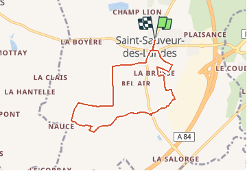
Tour Wandern von 7,2 km verfügbar auf Bretagne, Ille-et-Vilaine, Saint-Sauveur-des-Landes. Diese Tour wird von neoroll44 vorgeschlagen.
Beschreibung
Depuis la place de la mairie, vers le hameau des Saudres et le long du ruisseau "l'Everre".
Ort
Land:
France
Region :
Bretagne
Abteilung/Provinz :
Ille-et-Vilaine
Kommune :
Saint-Sauveur-des-Landes
Standort:
Unknown
Gehen Sie:(Dec)
Gehen Sie:(UTM)
625039 ; 5355938 (30U) N.
Kommentare
Touren in der Umgebung
![Tour Mountainbike Romagné - Romagne 23,07,22 - Photo](https://media.geolcdn.com/t/375/260/48c0ba94-0793-4f88-87d2-0737b1d0c97b.jpg&format=jpg&maxdim=2)
![Mountainbike Mountainbike](https://static1.geolcdn.com/sitytour/trail-icons/202.png)
Romagne 23,07,22
Mountainbike
Einfach
Romagné,
Bretagne,
Ille-et-Vilaine,
France
![](/images/other/stat-length.png)
37 km | 41 km-effort
1h 54min
![](https://static1.geolcdn.com/siteimages/upload/files/16400158638029165_repeat_loop_refresh_sync_direction_icon.png)
Ja
![Tour Mountainbike Romagné - Romagne 20.07.22 - Photo](https://media.geolcdn.com/t/375/260/3dd84c15-100e-4e06-82fa-fffa09e576e8.jpg&format=jpg&maxdim=2)
![Mountainbike Mountainbike](https://static1.geolcdn.com/sitytour/trail-icons/202.png)
Romagne 20.07.22
Mountainbike
Einfach
Romagné,
Bretagne,
Ille-et-Vilaine,
France
![](/images/other/stat-length.png)
37 km | 42 km-effort
1h 51min
![](https://static1.geolcdn.com/siteimages/upload/files/16400158638029165_repeat_loop_refresh_sync_direction_icon.png)
Ja
![Tour Mountainbike Romagné - Romagne 18,07,22. - Photo](https://media.geolcdn.com/t/375/260/ext.jpg?maxdim=2&url=https%3A%2F%2Fstatic1.geolcdn.com%2Fsiteimages%2Fupload%2Ffiles%2F1524743154velo.jpg)
![Mountainbike Mountainbike](https://static1.geolcdn.com/sitytour/trail-icons/202.png)
Romagne 18,07,22.
Mountainbike
Sehr schwierig
Romagné,
Bretagne,
Ille-et-Vilaine,
France
![](/images/other/stat-length.png)
39 km | 44 km-effort
2h 21min
![](https://static1.geolcdn.com/siteimages/upload/files/16400158638029165_repeat_loop_refresh_sync_direction_icon.png)
Ja
![Tour Mountainbike Romagné - Romagne par Vandel - Photo](https://media.geolcdn.com/t/375/260/b5198cbb-e99f-4f62-8f7e-359d8064bc3a.jpg&format=jpg&maxdim=2)
![Mountainbike Mountainbike](https://static1.geolcdn.com/sitytour/trail-icons/202.png)
Romagne par Vandel
Mountainbike
Einfach
Romagné,
Bretagne,
Ille-et-Vilaine,
France
![](/images/other/stat-length.png)
19,1 km | 22 km-effort
1h 6min
![](https://static1.geolcdn.com/siteimages/upload/files/16400158638029165_repeat_loop_refresh_sync_direction_icon.png)
Ja
![Tour Wandern Romagné - la zone la crochais - Photo](https://media.geolcdn.com/t/375/260/ext.jpg?maxdim=2&url=https%3A%2F%2Fstatic1.geolcdn.com%2Fsiteimages%2Fupload%2Ffiles%2F1553511878bg_sport_marche.png)
![Wandern Wandern](https://static1.geolcdn.com/sitytour/trail-icons/101.png)
la zone la crochais
Wandern
Schwierig
Romagné,
Bretagne,
Ille-et-Vilaine,
France
![](/images/other/stat-length.png)
11,5 km | 12,5 km-effort
3h 12min
![](https://static1.geolcdn.com/siteimages/upload/files/16400158638029165_repeat_loop_refresh_sync_direction_icon.png)
Nein
![Tour Wandern Saint-Sauveur-des-Landes - St-Sauveur_Noés - Photo](https://media.geolcdn.com/t/375/260/ext.jpg?maxdim=2&url=https%3A%2F%2Fstatic1.geolcdn.com%2Fsiteimages%2Fupload%2Ffiles%2F1553511878bg_sport_marche.png)
![Wandern Wandern](https://static1.geolcdn.com/sitytour/trail-icons/101.png)
St-Sauveur_Noés
Wandern
Medium
Saint-Sauveur-des-Landes,
Bretagne,
Ille-et-Vilaine,
France
![](/images/other/stat-length.png)
8,9 km | 10,1 km-effort
2h 20min
![](https://static1.geolcdn.com/siteimages/upload/files/16400158638029165_repeat_loop_refresh_sync_direction_icon.png)
Ja
![Tour Wandern Saint-Sauveur-des-Landes - St-Sauveur_Minette - Photo](https://media.geolcdn.com/t/375/260/ext.jpg?maxdim=2&url=https%3A%2F%2Fstatic1.geolcdn.com%2Fsiteimages%2Fupload%2Ffiles%2F1553511878bg_sport_marche.png)
![Wandern Wandern](https://static1.geolcdn.com/sitytour/trail-icons/101.png)
St-Sauveur_Minette
Wandern
Einfach
Saint-Sauveur-des-Landes,
Bretagne,
Ille-et-Vilaine,
France
![](/images/other/stat-length.png)
6,3 km | 7,3 km-effort
1h 40min
![](https://static1.geolcdn.com/siteimages/upload/files/16400158638029165_repeat_loop_refresh_sync_direction_icon.png)
Ja
![Tour Wandern Romagné - Romagné_Morière - Photo](https://media.geolcdn.com/t/375/260/ext.jpg?maxdim=2&url=https%3A%2F%2Fstatic1.geolcdn.com%2Fsiteimages%2Fupload%2Ffiles%2F1553511878bg_sport_marche.png)
![Wandern Wandern](https://static1.geolcdn.com/sitytour/trail-icons/101.png)
Romagné_Morière
Wandern
Einfach
Romagné,
Bretagne,
Ille-et-Vilaine,
France
![](/images/other/stat-length.png)
5,6 km | 6,1 km-effort
1h 40min
![](https://static1.geolcdn.com/siteimages/upload/files/16400158638029165_repeat_loop_refresh_sync_direction_icon.png)
Ja
![Tour Wandern Romagné - Romagné_Bonne Fontaine - Photo](https://media.geolcdn.com/t/375/260/ext.jpg?maxdim=2&url=https%3A%2F%2Fstatic1.geolcdn.com%2Fsiteimages%2Fupload%2Ffiles%2F1553511878bg_sport_marche.png)
![Wandern Wandern](https://static1.geolcdn.com/sitytour/trail-icons/101.png)
Romagné_Bonne Fontaine
Wandern
Einfach
Romagné,
Bretagne,
Ille-et-Vilaine,
France
![](/images/other/stat-length.png)
8,5 km | 9,6 km-effort
2h 10min
![](https://static1.geolcdn.com/siteimages/upload/files/16400158638029165_repeat_loop_refresh_sync_direction_icon.png)
Ja