![](/images/other/stat-length.png)
![Tour Schneeschuhwandern Saint-Étienne-de-Tinée - Mont FERANT - Photo](https://media.geolcdn.com/t/1900/400/ext.pjpeg?maxdim=2&url=https%3A%2F%2Fstatic1.geolcdn.com%2Fsiteimages%2Fupload%2Ffiles%2F1524743153raquette.jpg)
Mont FERANT
fredopaca
Benutzer
![Länge](/images/other/stat-length.png)
![Maximale Höhe](https://static1.geolcdn.com/siteimages/upload/files/1508320355ic_sort_altitude_max_24dp.png)
![Positive Höhendifferenz](https://static1.geolcdn.com/siteimages/upload/files/1508320355ic_sort_den_pos_24dp.png)
![Km-Effort](/images/other/stat-length.png)
![Min. Höhe](https://static1.geolcdn.com/siteimages/upload/files/1508320355ic_sort_altitude_min_24dp.png)
![Negative Höhendifferenz](https://static1.geolcdn.com/siteimages/upload/files/1508320355ic_sort_den_neg_24dp.png)
![Boucle](https://static1.geolcdn.com/siteimages/upload/files/16400158638029165_repeat_loop_refresh_sync_direction_icon.png)
![Schneeschuhwandern](https://static1.geolcdn.com/sitytour/trail-icons/504.png)
5h59
Schwierigkeit : Medium
![Scannen Sie diesen QR-Code, um die Tour in der SityTrail-Anwendung zu öffnen](https://capi.geolives.com/qq0zvz2zws4bq2lad0pu/sitytour/trails/544479/qr.png?size=200)
Kostenlosegpshiking-Anwendung
Über SityTrail
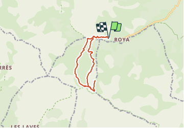
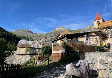
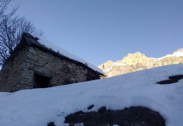
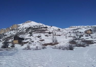
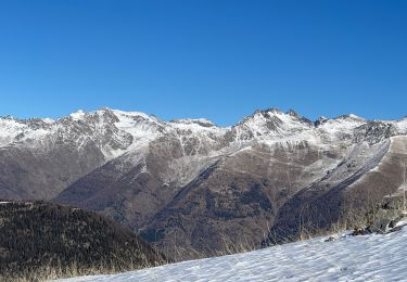
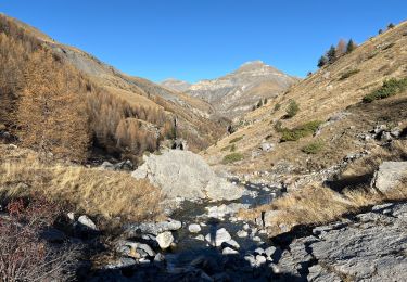
Tour Schneeschuhwandern von 12,3 km verfügbar auf Provence-Alpes-Côte d'Azur, Seealpen, Saint-Étienne-de-Tinée. Diese Tour wird von fredopaca vorgeschlagen.
Beschreibung
départ parking supérieur de ROYA balise 140 direction vallon de l Alp direction balise 95 col de crous prendre sur la gauche vers les crêtes de la cime NEGRE arriver sur le premier plateau vous prendrez dur votre gauche vers crête de la faysse et le mont FERANT 2382 mt retour idem ou une boucle vers le col de crous
Ort
Kommentare
Touren in der Umgebung
![Tour Wandern Saint-Étienne-de-Tinée - Réel Roya Col de Crousette Stèle Valette Petit Mounier et Mounier - Photo](https://media.geolcdn.com/t/375/260/b5c86927-6c55-4c7f-afae-58ada10c53b3.jpg&format=jpg&maxdim=2)
![Wandern Wandern](https://static1.geolcdn.com/sitytour/trail-icons/101.png)
Wandern
![](/images/other/stat-length.png)
![](https://static1.geolcdn.com/siteimages/upload/files/16400158638029165_repeat_loop_refresh_sync_direction_icon.png)
![Tour Zu Fuß Saint-Étienne-de-Tinée - Cime de la Bercha - Photo](https://media.geolcdn.com/t/375/260/06e4d46f-e317-406d-bd2c-01041e541c38.jpeg&format=jpg&maxdim=2)
![Zu Fuß Zu Fuß](https://static1.geolcdn.com/sitytour/trail-icons/100.png)
Zu Fuß
![](/images/other/stat-length.png)
![](https://static1.geolcdn.com/siteimages/upload/files/16400158638029165_repeat_loop_refresh_sync_direction_icon.png)
![Tour Skiwanderen Saint-Étienne-de-Tinée - Mont Triboulet et Mont Rion - Photo](https://media.geolcdn.com/t/375/260/628b9303-05b3-4c82-bf08-aa61a07e7015.jpg&format=jpg&maxdim=2)
![Skiwanderen Skiwanderen](https://static1.geolcdn.com/sitytour/trail-icons/503.png)
Skiwanderen
![](/images/other/stat-length.png)
![](https://static1.geolcdn.com/siteimages/upload/files/16400158638029165_repeat_loop_refresh_sync_direction_icon.png)
![Tour Skiwanderen Saint-Étienne-de-Tinée - Las Donnas et baisse du Colombier - Photo](https://media.geolcdn.com/t/375/260/0cedeff1-332d-460c-af06-a42d22a26fa2.jpg&format=jpg&maxdim=2)
![Skiwanderen Skiwanderen](https://static1.geolcdn.com/sitytour/trail-icons/503.png)
Skiwanderen
![](/images/other/stat-length.png)
![](https://static1.geolcdn.com/siteimages/upload/files/16400158638029165_repeat_loop_refresh_sync_direction_icon.png)
![Tour Schneeschuhwandern Saint-Étienne-de-Tinée - Cabane Vieille - Photo](https://media.geolcdn.com/t/375/260/d08ad509-8448-4a00-bc95-11334e53fd24.jpg&format=jpg&maxdim=2)
![Schneeschuhwandern Schneeschuhwandern](https://static1.geolcdn.com/sitytour/trail-icons/504.png)
Schneeschuhwandern
![](/images/other/stat-length.png)
![](https://static1.geolcdn.com/siteimages/upload/files/16400158638029165_repeat_loop_refresh_sync_direction_icon.png)
![Tour Wandern Saint-Étienne-de-Tinée - Le Mounier - Photo](https://media.geolcdn.com/t/375/260/6d3039c6-e5bd-4a5c-b5ca-417ffa1a190a.jpg&format=jpg&maxdim=2)
![Wandern Wandern](https://static1.geolcdn.com/sitytour/trail-icons/101.png)
Wandern
![](/images/other/stat-length.png)
![](https://static1.geolcdn.com/siteimages/upload/files/16400158638029165_repeat_loop_refresh_sync_direction_icon.png)
![Tour Wandern Saint-Étienne-de-Tinée - Le Corborant - Photo](https://media.geolcdn.com/t/375/260/4e6a72e4-8dfa-499a-bed5-882b283528e3.jpeg&format=jpg&maxdim=2)
![Wandern Wandern](https://static1.geolcdn.com/sitytour/trail-icons/101.png)
Wandern
![](/images/other/stat-length.png)
![](https://static1.geolcdn.com/siteimages/upload/files/16400158638029165_repeat_loop_refresh_sync_direction_icon.png)
![Tour Wandern Saint-Étienne-de-Tinée - De Roya au Col de Blainon, baisse herisson - Photo](https://media.geolcdn.com/t/375/260/f3ff390a-3102-4c2f-baae-0abdbac6b210.jpg&format=jpg&maxdim=2)
![Wandern Wandern](https://static1.geolcdn.com/sitytour/trail-icons/101.png)
Wandern
![](/images/other/stat-length.png)
![](https://static1.geolcdn.com/siteimages/upload/files/16400158638029165_repeat_loop_refresh_sync_direction_icon.png)
![Tour sport Saint-Étienne-de-Tinée - Tête de l autaret Lagos colla longa - Photo](https://media.geolcdn.com/t/375/260/0f54380f-0cc0-41e9-83d3-976012bf1985.jpg&format=jpg&maxdim=2)
sport
![](/images/other/stat-length.png)
![](https://static1.geolcdn.com/siteimages/upload/files/16400158638029165_repeat_loop_refresh_sync_direction_icon.png)