![](/images/other/stat-length.png)
![Tour Schneeschuhwandern Dorres - Chapelle de Belloc - Photo](https://media.geolcdn.com/t/1900/400/ext.pjpeg?maxdim=2&url=https%3A%2F%2Fservices.sitytrail.com%2FGeolivesWS%2FDownloadMedia.ashx%3FTrailID%3D539435%26Media%3Dfix__20160317120113.jpg)
Chapelle de Belloc
jpipacific
Benutzer
![Länge](/images/other/stat-length.png)
Länge
7,9 km
![Maximale Höhe](https://static1.geolcdn.com/siteimages/upload/files/1508320355ic_sort_altitude_max_24dp.png)
Maximale Höhe
1700 m
![Positive Höhendifferenz](https://static1.geolcdn.com/siteimages/upload/files/1508320355ic_sort_den_pos_24dp.png)
Positive Höhendifferenz
261 m
![Km-Effort](/images/other/stat-length.png)
Km-Effort
11,4 km
![Min. Höhe](https://static1.geolcdn.com/siteimages/upload/files/1508320355ic_sort_altitude_min_24dp.png)
Min. Höhe
1448 m
![Negative Höhendifferenz](https://static1.geolcdn.com/siteimages/upload/files/1508320355ic_sort_den_neg_24dp.png)
Negative Höhendifferenz
261 m
![Boucle](https://static1.geolcdn.com/siteimages/upload/files/16400158638029165_repeat_loop_refresh_sync_direction_icon.png)
Boucle
Ja
Erstellungsdatum :
2016-03-18 00:00:00.0
Letzte Änderung :
2016-03-18 00:00:00.0
![Schneeschuhwandern](https://static1.geolcdn.com/sitytour/trail-icons/504.png)
2h37
Schwierigkeit : Einfach
![Scannen Sie diesen QR-Code, um die Tour in der SityTrail-Anwendung zu öffnen](https://capi.geolives.com/qq0zvz2zws4bq2lad0pu/sitytour/trails/539435/qr.png?size=200)
Kostenlosegpshiking-Anwendung
Über SityTrail
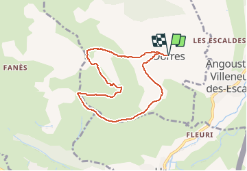
Tour Schneeschuhwandern von 7,9 km verfügbar auf Okzitanien, Ostpyrenäen, Dorres. Diese Tour wird von jpipacific vorgeschlagen.
Beschreibung
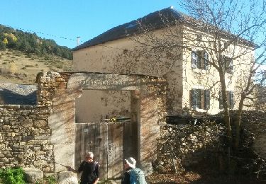
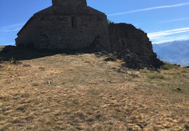
Belle rando facile. Une montée un peu raide, longue descente en pente douce avec un panorama magnifique tout du long. A la chapelle panorama superbe sur toute la vallée et les montagnes environnantes.
Ort
Land:
France
Region :
Okzitanien
Abteilung/Provinz :
Ostpyrenäen
Kommune :
Dorres
Standort:
Unknown
Gehen Sie:(Dec)
Gehen Sie:(UTM)
412905 ; 4704137 (31T) N.
Kommentare
Touren in der Umgebung
![Tour Wandern Ur - de Ur vers La Chapelle de Belloc - Photo](https://media.geolcdn.com/t/375/260/ext.jpg?maxdim=2&url=https%3A%2F%2Fservices.sitytrail.com%2FGeolivesWS%2FDownloadMedia.ashx%3FTrailID%3D661447%26Media%3D20161117163202.jpg)
![Wandern Wandern](https://static1.geolcdn.com/sitytour/trail-icons/101.png)
de Ur vers La Chapelle de Belloc
Wandern
Einfach
(1)
Ur,
Okzitanien,
Ostpyrenäen,
France
![](/images/other/stat-length.png)
20 km | 28 km-effort
7h 14min
![](https://static1.geolcdn.com/siteimages/upload/files/16400158638029165_repeat_loop_refresh_sync_direction_icon.png)
Ja
![Tour Wandern Estavar - 20220328 Estavar-Tartassonne(?) - Photo](https://media.geolcdn.com/t/375/260/d3a84297-78f4-4823-a8d6-7ab122d863c3.jpg&format=jpg&maxdim=2)
![Wandern Wandern](https://static1.geolcdn.com/sitytour/trail-icons/101.png)
20220328 Estavar-Tartassonne(?)
Wandern
Medium
Estavar,
Okzitanien,
Ostpyrenäen,
France
![](/images/other/stat-length.png)
14,8 km | 22 km-effort
3h 16min
![](https://static1.geolcdn.com/siteimages/upload/files/16400158638029165_repeat_loop_refresh_sync_direction_icon.png)
Ja
![Schneeschuhwandern Schneeschuhwandern](https://static1.geolcdn.com/sitytour/trail-icons/504.png)
2021-02-10 Sortie CAF - Port de Maurà depuis Dorres
Schneeschuhwandern
Schwierig
Dorres,
Okzitanien,
Ostpyrenäen,
France
![](/images/other/stat-length.png)
17,9 km | 31 km-effort
9h 0min
![](https://static1.geolcdn.com/siteimages/upload/files/16400158638029165_repeat_loop_refresh_sync_direction_icon.png)
Ja
![Wandern Wandern](https://static1.geolcdn.com/sitytour/trail-icons/101.png)
2021-02-09 Sortie CAF - Dorres - Chapelle de Belloc - Dolmen de Brangoli
Wandern
Einfach
Dorres,
Okzitanien,
Ostpyrenäen,
France
![](/images/other/stat-length.png)
13 km | 19,3 km-effort
5h 0min
![](https://static1.geolcdn.com/siteimages/upload/files/16400158638029165_repeat_loop_refresh_sync_direction_icon.png)
Ja
![Tour Wandern Dorres - d'ores 2 - Photo](https://media.geolcdn.com/t/375/260/8d443e8b-e448-46c9-8d35-e5b2b8654ee9.jpg&format=jpg&maxdim=2)
![Wandern Wandern](https://static1.geolcdn.com/sitytour/trail-icons/101.png)
![Tour Wandern Enveitg - Bena - Photo](https://media.geolcdn.com/t/375/260/165e97a2-1242-4fc7-ad8f-1f50eaed5ba5.jpg&format=jpg&maxdim=2)
![Wandern Wandern](https://static1.geolcdn.com/sitytour/trail-icons/101.png)
![Tour Wandern Dorres - Le chemin du Belloc - Photo](https://media.geolcdn.com/t/375/260/baea90ac-684a-4947-b800-0eea24315e65.jpg&format=jpg&maxdim=2)
![Wandern Wandern](https://static1.geolcdn.com/sitytour/trail-icons/101.png)
Le chemin du Belloc
Wandern
Dorres,
Okzitanien,
Ostpyrenäen,
France
![](/images/other/stat-length.png)
5,6 km | 8,9 km-effort
1h 44min
![](https://static1.geolcdn.com/siteimages/upload/files/16400158638029165_repeat_loop_refresh_sync_direction_icon.png)
Nein
![Tour Wandern Dorres - Dorres vers les estanyets - Photo](https://media.geolcdn.com/t/375/260/ext.jpg?maxdim=2&url=https%3A%2F%2Fservices.sitytrail.com%2FGeolivesWS%2FDownloadMedia.ashx%3FTrailID%3D1011850%26Media%3Dfix__20180727093345.jpg)
![Wandern Wandern](https://static1.geolcdn.com/sitytour/trail-icons/101.png)
Dorres vers les estanyets
Wandern
Schwierig
Dorres,
Okzitanien,
Ostpyrenäen,
France
![](/images/other/stat-length.png)
18 km | 30 km-effort
8h 49min
![](https://static1.geolcdn.com/siteimages/upload/files/16400158638029165_repeat_loop_refresh_sync_direction_icon.png)
Ja
![Tour Wandern Ur - ur - Photo](https://media.geolcdn.com/t/375/260/ext.jpg?maxdim=2&url=https%3A%2F%2Fservices.sitytrail.com%2FGeolivesWS%2FDownloadMedia.ashx%3FTrailID%3D664005%26Media%3Dfix__20161117140353.jpg)
![Wandern Wandern](https://static1.geolcdn.com/sitytour/trail-icons/101.png)