![](/images/other/stat-length.png)
![Tour Wandern Vexin-sur-Epte - Rando Santé 1 - Fontenay en Vexin - Photo](https://media.geolcdn.com/t/1900/400/ext.pjpeg?maxdim=2&url=https%3A%2F%2Fstatic1.geolcdn.com%2Fsiteimages%2Fupload%2Ffiles%2F1553511878bg_sport_marche.png)
Rando Santé 1 - Fontenay en Vexin
marcel.F
Benutzer
![Länge](/images/other/stat-length.png)
Länge
4,9 km
![Maximale Höhe](https://static1.geolcdn.com/siteimages/upload/files/1508320355ic_sort_altitude_max_24dp.png)
Maximale Höhe
145 m
![Positive Höhendifferenz](https://static1.geolcdn.com/siteimages/upload/files/1508320355ic_sort_den_pos_24dp.png)
Positive Höhendifferenz
77 m
![Km-Effort](/images/other/stat-length.png)
Km-Effort
5,9 km
![Min. Höhe](https://static1.geolcdn.com/siteimages/upload/files/1508320355ic_sort_altitude_min_24dp.png)
Min. Höhe
99 m
![Negative Höhendifferenz](https://static1.geolcdn.com/siteimages/upload/files/1508320355ic_sort_den_neg_24dp.png)
Negative Höhendifferenz
76 m
![Boucle](https://static1.geolcdn.com/siteimages/upload/files/16400158638029165_repeat_loop_refresh_sync_direction_icon.png)
Boucle
Ja
Erstellungsdatum :
2019-04-01 20:24:02.411
Letzte Änderung :
2019-04-07 14:10:37.75
![Wandern](https://static1.geolcdn.com/sitytour/trail-icons/101.png)
1h30
Schwierigkeit : Einfach
![Scannen Sie diesen QR-Code, um die Tour in der SityTrail-Anwendung zu öffnen](https://capi.geolives.com/qq0zvz2zws4bq2lad0pu/sitytour/trails/532854/qr.png?size=200)
Kostenlosegpshiking-Anwendung
Über SityTrail
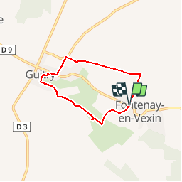
Tour Wandern von 4,9 km verfügbar auf Normandie, Eure, Vexin-sur-Epte. Diese Tour wird von marcel.F vorgeschlagen.
Beschreibung
Boucle au départ du parking école de Fontenay en Vexin (accès par D181 après Les Thilliers en Vexin)
via moulin des Groux et Guitry
Ort
Land:
France
Region :
Normandie
Abteilung/Provinz :
Eure
Kommune :
Vexin-sur-Epte
Standort:
Unknown
Gehen Sie:(Dec)
Gehen Sie:(UTM)
395627 ; 5451836 (31U) N.
Kommentare
Touren in der Umgebung
![Tour Wandern Mézières-en-Vexin - Mézières-en-Vexin - François 1er - Photo](https://media.geolcdn.com/t/375/260/ext.jpg?maxdim=2&url=https%3A%2F%2Fstatic1.geolcdn.com%2Fsiteimages%2Fupload%2Ffiles%2F1553511878bg_sport_marche.png)
![Wandern Wandern](https://static1.geolcdn.com/sitytour/trail-icons/101.png)
Mézières-en-Vexin - François 1er
Wandern
Einfach
(1)
Mézières-en-Vexin,
Normandie,
Eure,
France
![](/images/other/stat-length.png)
11 km | 13,1 km-effort
2h 50min
![](https://static1.geolcdn.com/siteimages/upload/files/16400158638029165_repeat_loop_refresh_sync_direction_icon.png)
Ja
![Tour Wandern Vexin-sur-Epte - Tourny - le moulin de pierre variante 2 - Photo](https://media.geolcdn.com/t/375/260/ext.jpg?maxdim=2&url=https%3A%2F%2Fservices.sitytrail.com%2FGeolivesWS%2FDownloadMedia.ashx%3FTrailID%3D1098186%26Media%3Df5555db9-f7bc-4527-9b07-edd230d56814.jpg)
![Wandern Wandern](https://static1.geolcdn.com/sitytour/trail-icons/101.png)
Tourny - le moulin de pierre variante 2
Wandern
Einfach
Vexin-sur-Epte,
Normandie,
Eure,
France
![](/images/other/stat-length.png)
9,9 km | 11,1 km-effort
2h 22min
![](https://static1.geolcdn.com/siteimages/upload/files/16400158638029165_repeat_loop_refresh_sync_direction_icon.png)
Ja
![Tour Wandern Vexin-sur-Epte - Rando Douce 2 - Tourny - Photo](https://media.geolcdn.com/t/375/260/ext.jpg?maxdim=2&url=https%3A%2F%2Fservices.sitytrail.com%2FGeolivesWS%2FDownloadMedia.ashx%3FTrailID%3D532902%26Media%3Df5555db9-f7bc-4527-9b07-edd230d56814.jpg)
![Wandern Wandern](https://static1.geolcdn.com/sitytour/trail-icons/101.png)
Rando Douce 2 - Tourny
Wandern
Medium
Vexin-sur-Epte,
Normandie,
Eure,
France
![](/images/other/stat-length.png)
6,9 km | 7,8 km-effort
2h 0min
![](https://static1.geolcdn.com/siteimages/upload/files/16400158638029165_repeat_loop_refresh_sync_direction_icon.png)
Ja
![Tour Wandern Vexin-sur-Epte - Rando Santé 1 - Tourny - Photo](https://media.geolcdn.com/t/375/260/ext.jpg?maxdim=2&url=https%3A%2F%2Fservices.sitytrail.com%2FGeolivesWS%2FDownloadMedia.ashx%3FTrailID%3D532901%26Media%3Df5555db9-f7bc-4527-9b07-edd230d56814.jpg)
![Wandern Wandern](https://static1.geolcdn.com/sitytour/trail-icons/101.png)
Rando Santé 1 - Tourny
Wandern
Einfach
Vexin-sur-Epte,
Normandie,
Eure,
France
![](/images/other/stat-length.png)
4,5 km | 5,1 km-effort
1h 30min
![](https://static1.geolcdn.com/siteimages/upload/files/16400158638029165_repeat_loop_refresh_sync_direction_icon.png)
Ja
![Tour Wandern Vexin-sur-Epte - Tourny - le moulin de pierre court - Photo](https://media.geolcdn.com/t/375/260/ext.jpg?maxdim=2&url=https%3A%2F%2Fservices.sitytrail.com%2FGeolivesWS%2FDownloadMedia.ashx%3FTrailID%3D527716%26Media%3Df5555db9-f7bc-4527-9b07-edd230d56814.jpg)
![Wandern Wandern](https://static1.geolcdn.com/sitytour/trail-icons/101.png)
Tourny - le moulin de pierre court
Wandern
Einfach
Vexin-sur-Epte,
Normandie,
Eure,
France
![](/images/other/stat-length.png)
8 km | 9 km-effort
1h 59min
![](https://static1.geolcdn.com/siteimages/upload/files/16400158638029165_repeat_loop_refresh_sync_direction_icon.png)
Ja
![Tour Wandern Villers-en-Vexin - Villers en Vexin à Cantiers - Photo](https://media.geolcdn.com/t/375/260/ext.jpg?maxdim=2&url=https%3A%2F%2Fstatic1.geolcdn.com%2Fsiteimages%2Fupload%2Ffiles%2F1553511878bg_sport_marche.png)
![Wandern Wandern](https://static1.geolcdn.com/sitytour/trail-icons/101.png)
Villers en Vexin à Cantiers
Wandern
Medium
Villers-en-Vexin,
Normandie,
Eure,
France
![](/images/other/stat-length.png)
9,1 km | 10 km-effort
2h 16min
![](https://static1.geolcdn.com/siteimages/upload/files/16400158638029165_repeat_loop_refresh_sync_direction_icon.png)
Ja
![Tour Wandern Vexin-sur-Epte - TOURNY Version MC2 - Photo](https://media.geolcdn.com/t/375/260/ext.jpg?maxdim=2&url=https%3A%2F%2Fstatic1.geolcdn.com%2Fsiteimages%2Fupload%2Ffiles%2F1553511878bg_sport_marche.png)
![Wandern Wandern](https://static1.geolcdn.com/sitytour/trail-icons/101.png)
TOURNY Version MC2
Wandern
Sehr leicht
Vexin-sur-Epte,
Normandie,
Eure,
France
![](/images/other/stat-length.png)
9,7 km | 10,7 km-effort
1h 53min
![](https://static1.geolcdn.com/siteimages/upload/files/16400158638029165_repeat_loop_refresh_sync_direction_icon.png)
Ja
![Tour Wandern Vexin-sur-Epte - Tourny MOulin de Pierre 3 - Photo](https://media.geolcdn.com/t/375/260/ext.jpg?maxdim=2&url=https%3A%2F%2Fstatic1.geolcdn.com%2Fsiteimages%2Fupload%2Ffiles%2F1553511878bg_sport_marche.png)
![Wandern Wandern](https://static1.geolcdn.com/sitytour/trail-icons/101.png)
Tourny MOulin de Pierre 3
Wandern
Schwierig
Vexin-sur-Epte,
Normandie,
Eure,
France
![](/images/other/stat-length.png)
12,2 km | 13,4 km-effort
2h 59min
![](https://static1.geolcdn.com/siteimages/upload/files/16400158638029165_repeat_loop_refresh_sync_direction_icon.png)
Ja
![Tour Wandern Vexin-sur-Epte - Tourny (le moulin de pierre)_12Km - Photo](https://media.geolcdn.com/t/375/260/ext.jpg?maxdim=2&url=https%3A%2F%2Fstatic1.geolcdn.com%2Fsiteimages%2Fupload%2Ffiles%2F1553511878bg_sport_marche.png)
![Wandern Wandern](https://static1.geolcdn.com/sitytour/trail-icons/101.png)
Tourny (le moulin de pierre)_12Km
Wandern
Einfach
Vexin-sur-Epte,
Normandie,
Eure,
France
![](/images/other/stat-length.png)
12 km | 13,2 km-effort
2h 55min
![](https://static1.geolcdn.com/siteimages/upload/files/16400158638029165_repeat_loop_refresh_sync_direction_icon.png)
Ja