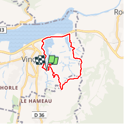
![](/images/other/stat-length.png)
![Tour Wandern Vinça - 66 VINÇA, promenade entre VINÇA et Rodés, tour des lacs de Conillac et des Escoumes - Photo](https://media.geolcdn.com/t/1900/400/ext.pjpeg?maxdim=2&url=https%3A%2F%2Fservices.sitytrail.com%2FGeolivesWS%2FDownloadMedia.ashx%3FTrailID%3D517692%26Media%3D20160124132343.jpg)
66 VINÇA, promenade entre VINÇA et Rodés, tour des lacs de Conillac et des Escoumes
jeff66
Benutzer
![Länge](/images/other/stat-length.png)
![Maximale Höhe](https://static1.geolcdn.com/siteimages/upload/files/1508320355ic_sort_altitude_max_24dp.png)
![Positive Höhendifferenz](https://static1.geolcdn.com/siteimages/upload/files/1508320355ic_sort_den_pos_24dp.png)
![Km-Effort](/images/other/stat-length.png)
![Min. Höhe](https://static1.geolcdn.com/siteimages/upload/files/1508320355ic_sort_altitude_min_24dp.png)
![Negative Höhendifferenz](https://static1.geolcdn.com/siteimages/upload/files/1508320355ic_sort_den_neg_24dp.png)
![Boucle](https://static1.geolcdn.com/siteimages/upload/files/16400158638029165_repeat_loop_refresh_sync_direction_icon.png)
![Wandern](https://static1.geolcdn.com/sitytour/trail-icons/101.png)
1h09
Schwierigkeit : Einfach
![Scannen Sie diesen QR-Code, um die Tour in der SityTrail-Anwendung zu öffnen](https://capi.geolives.com/qq0zvz2zws4bq2lad0pu/sitytour/trails/517692/qr.png?size=200)
Kostenlosegpshiking-Anwendung
Über SityTrail
Tour Wandern von 6,2 km verfügbar auf Okzitanien, Ostpyrenäen, Vinça. Diese Tour wird von jeff66 vorgeschlagen.
Beschreibung
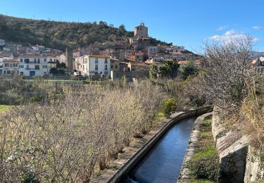
66 VINÇA, parking du camping du lac et du cimetière, vue sur VINÇA, Vall Llovera, route goudronnée puis piste, vue sur Rodés et la plaine du Roussillon puis sur le barrage et le lac de Conillac, lac des Escoumes, longer la voie ferrée - la RN116 et le barrage, PLAGE et tennis club
Ort
Kommentare
Touren in der Umgebung
![Tour Mountainbike Vinça - parcours ronde de Sahorle 2013 - Photo](https://media.geolcdn.com/t/375/260/ext.jpg?maxdim=2&url=https%3A%2F%2Fstatic1.geolcdn.com%2Fsiteimages%2Fupload%2Ffiles%2F1524743154velo.jpg)
![Mountainbike Mountainbike](https://static1.geolcdn.com/sitytour/trail-icons/202.png)
Mountainbike
![](/images/other/stat-length.png)
![](https://static1.geolcdn.com/siteimages/upload/files/16400158638029165_repeat_loop_refresh_sync_direction_icon.png)
![Tour sport Finestret - 20250109 petite boucle depuis Finestret - Photo](https://media.geolcdn.com/t/375/260/e154baa2-7741-43ff-8fd2-a9135305a5c2.jpg&format=jpg&maxdim=2)
sport
![](/images/other/stat-length.png)
![](https://static1.geolcdn.com/siteimages/upload/files/16400158638029165_repeat_loop_refresh_sync_direction_icon.png)
![Tour Wandern Marquixanes - marquixanes - Photo](https://media.geolcdn.com/t/375/260/9f15ae53-8545-42f8-abb5-8d004f9aced2.jpg&format=jpg&maxdim=2)
![Wandern Wandern](https://static1.geolcdn.com/sitytour/trail-icons/101.png)
Wandern
![](/images/other/stat-length.png)
![](https://static1.geolcdn.com/siteimages/upload/files/16400158638029165_repeat_loop_refresh_sync_direction_icon.png)
![Tour Wandern Arboussols - Marcevol - Photo](https://media.geolcdn.com/t/375/260/c36f51d8-a44d-419f-a023-7a6ff9003ad5.jpg&format=jpg&maxdim=2)
![Wandern Wandern](https://static1.geolcdn.com/sitytour/trail-icons/101.png)
Wandern
![](/images/other/stat-length.png)
![](https://static1.geolcdn.com/siteimages/upload/files/16400158638029165_repeat_loop_refresh_sync_direction_icon.png)
![Tour Wandern Boule-d'Amont - 20240104 Tour depuis le prieuré de Serrabonne - Photo](https://media.geolcdn.com/t/375/260/a082747f-89ab-4e46-8caf-fd728589230f.jpg&format=jpg&maxdim=2)
![Wandern Wandern](https://static1.geolcdn.com/sitytour/trail-icons/101.png)
Wandern
![](/images/other/stat-length.png)
![](https://static1.geolcdn.com/siteimages/upload/files/16400158638029165_repeat_loop_refresh_sync_direction_icon.png)
![Tour Wandern Rodès - 20221222 Rodés - Domanova…. Boucle - Photo](https://media.geolcdn.com/t/375/260/a3e631e7-3bf6-4340-8786-449d4c4dba31.jpg&format=jpg&maxdim=2)
![Wandern Wandern](https://static1.geolcdn.com/sitytour/trail-icons/101.png)
Wandern
![](/images/other/stat-length.png)
![](https://static1.geolcdn.com/siteimages/upload/files/16400158638029165_repeat_loop_refresh_sync_direction_icon.png)
![Tour Wandern Rodès - Gorges de la Guillera - Photo](https://media.geolcdn.com/t/375/260/87ffb17c-6b51-479b-b62e-81586c0f819f.jpg&format=jpg&maxdim=2)
![Wandern Wandern](https://static1.geolcdn.com/sitytour/trail-icons/101.png)
Wandern
![](/images/other/stat-length.png)
![](https://static1.geolcdn.com/siteimages/upload/files/16400158638029165_repeat_loop_refresh_sync_direction_icon.png)
![Tour Wandern Rodès - 20220217 au départ de Rodes - Photo](https://media.geolcdn.com/t/375/260/d4c22c06-1901-4b1d-a9f2-7a9ffb0df265.jpg&format=jpg&maxdim=2)
![Wandern Wandern](https://static1.geolcdn.com/sitytour/trail-icons/101.png)
Wandern
![](/images/other/stat-length.png)
![](https://static1.geolcdn.com/siteimages/upload/files/16400158638029165_repeat_loop_refresh_sync_direction_icon.png)
![Tour Wandern Bouleternère - Bouleternere - Photo](https://media.geolcdn.com/t/375/260/b8679bcf-38b4-4ac8-93cb-e26997648e61.jpg&format=jpg&maxdim=2)
![Wandern Wandern](https://static1.geolcdn.com/sitytour/trail-icons/101.png)
Wandern
![](/images/other/stat-length.png)
![](https://static1.geolcdn.com/siteimages/upload/files/16400158638029165_repeat_loop_refresh_sync_direction_icon.png)
cassagne