![](/images/other/stat-length.png)
Bouin_Les écluses
neoroll44
Benutzer
![Länge](/images/other/stat-length.png)
Länge
12,9 km
![Maximale Höhe](https://static1.geolcdn.com/siteimages/upload/files/1508320355ic_sort_altitude_max_24dp.png)
Maximale Höhe
6 m
![Positive Höhendifferenz](https://static1.geolcdn.com/siteimages/upload/files/1508320355ic_sort_den_pos_24dp.png)
Positive Höhendifferenz
34 m
![Km-Effort](/images/other/stat-length.png)
Km-Effort
13,4 km
![Min. Höhe](https://static1.geolcdn.com/siteimages/upload/files/1508320355ic_sort_altitude_min_24dp.png)
Min. Höhe
-2 m
![Negative Höhendifferenz](https://static1.geolcdn.com/siteimages/upload/files/1508320355ic_sort_den_neg_24dp.png)
Negative Höhendifferenz
35 m
![Boucle](https://static1.geolcdn.com/siteimages/upload/files/16400158638029165_repeat_loop_refresh_sync_direction_icon.png)
Boucle
Ja
Erstellungsdatum :
2016-03-09 00:00:00.0
Letzte Änderung :
2016-03-09 00:00:00.0
![Wandern](https://static1.geolcdn.com/sitytour/trail-icons/101.png)
2h19
Schwierigkeit : Einfach
![Scannen Sie diesen QR-Code, um die Tour in der SityTrail-Anwendung zu öffnen](https://capi.geolives.com/qq0zvz2zws4bq2lad0pu/sitytour/trails/516620/qr.png?size=200)
Kostenlosegpshiking-Anwendung
Über SityTrail
Tour Wandern von 12,9 km verfügbar auf Pays de la Loire, Vendée, Bouin. Diese Tour wird von neoroll44 vorgeschlagen.
Beschreibung
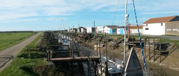
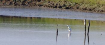
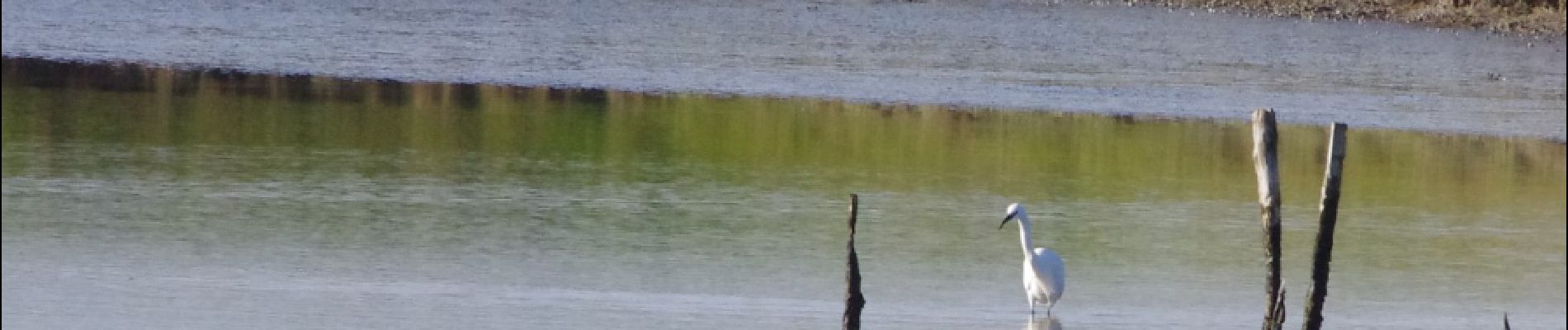
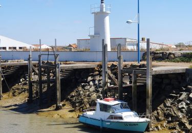
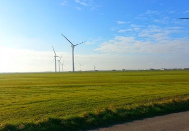
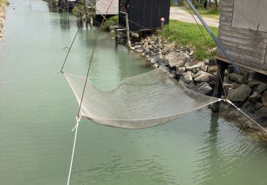
Depuis l'église, suivez le circuit 1 à travers le marais puis bifurquez à droite vers l'écluse des pêcheries. Longez la digue et rejoignez le circuit 1 après les pars à huîtres. Repartez vers le port des Champs, approchez des éoliennes et rentrez par la petite route.
Ort
Land:
France
Region :
Pays de la Loire
Abteilung/Provinz :
Vendée
Kommune :
Bouin
Standort:
Unknown
Gehen Sie:(Dec)
Gehen Sie:(UTM)
576154 ; 5202828 (30T) N.
Kommentare
Touren in der Umgebung
![Tour Fahrrad Bouin - bouin - port des brochets - Photo](https://media.geolcdn.com/t/375/260/ext.jpg?maxdim=2&url=https%3A%2F%2Fstatic1.geolcdn.com%2Fsiteimages%2Fupload%2Ffiles%2F1524743154velo.jpg)
![Fahrrad Fahrrad](https://static1.geolcdn.com/sitytour/trail-icons/200.png)
bouin - port des brochets
Fahrrad
Sehr leicht
(1)
Bouin,
Pays de la Loire,
Vendée,
France
![](/images/other/stat-length.png)
15,8 km | 16,4 km-effort
1h 50min
![](https://static1.geolcdn.com/siteimages/upload/files/16400158638029165_repeat_loop_refresh_sync_direction_icon.png)
Ja
![Tour Hybrid-Bike Bouin - Bouin-Boucle marais et digues - Photo](https://media.geolcdn.com/t/375/260/ext.jpg?maxdim=2&url=https%3A%2F%2Fmedia.geolcdn.com%2Ff%2F76a8df03-2986-44c5-9c04-b5c448f6a754.jpg)
![Hybrid-Bike Hybrid-Bike](https://static1.geolcdn.com/sitytour/trail-icons/203.png)
Bouin-Boucle marais et digues
Hybrid-Bike
Sehr leicht
Bouin,
Pays de la Loire,
Vendée,
France
![](/images/other/stat-length.png)
14,2 km | 14,6 km-effort
1h 29min
![](https://static1.geolcdn.com/siteimages/upload/files/16400158638029165_repeat_loop_refresh_sync_direction_icon.png)
Ja
![Tour Zu Fuß Bouin - Vers la Mer et les Digues - Photo](https://media.geolcdn.com/t/375/260/ext.jpg?maxdim=2&url=https%3A%2F%2Fmedia.geolcdn.com%2Ff%2F4ef582e9-f45f-4cb1-9a18-91197588b89d.jpeg)
![Zu Fuß Zu Fuß](https://static1.geolcdn.com/sitytour/trail-icons/100.png)
Vers la Mer et les Digues
Zu Fuß
Einfach
Bouin,
Pays de la Loire,
Vendée,
France
![](/images/other/stat-length.png)
9,6 km | 9,9 km-effort
2h 15min
![](https://static1.geolcdn.com/siteimages/upload/files/16400158638029165_repeat_loop_refresh_sync_direction_icon.png)
Ja
![Tour Zu Fuß Bouin - Chemin des Oiseaux - Photo](https://media.geolcdn.com/t/375/260/ext.jpg?maxdim=2&url=https%3A%2F%2Fmedia.geolcdn.com%2Ff%2Fafc4cdca-c735-43d5-92c0-996474eda780.jpeg)
![Zu Fuß Zu Fuß](https://static1.geolcdn.com/sitytour/trail-icons/100.png)
Chemin des Oiseaux
Zu Fuß
Einfach
Bouin,
Pays de la Loire,
Vendée,
France
![](/images/other/stat-length.png)
13,8 km | 14,2 km-effort
3h 13min
![](https://static1.geolcdn.com/siteimages/upload/files/16400158638029165_repeat_loop_refresh_sync_direction_icon.png)
Nein
![Tour Wandern Bouin - Bouin - Photo](https://media.geolcdn.com/t/375/260/ext.jpg?maxdim=2&url=https%3A%2F%2Fmedia.geolcdn.com%2Ff%2F1b7acdf2-1617-4b0e-aa20-13ce31269f6d.jpg)
![Wandern Wandern](https://static1.geolcdn.com/sitytour/trail-icons/101.png)
![Tour Wandern Bouin - Bouin_Le port des champs - Photo](https://media.geolcdn.com/t/375/260/ext.jpg?maxdim=2&url=https%3A%2F%2Fservices.sitytrail.com%2FGeolivesWS%2FDownloadMedia.ashx%3FTrailID%3D517646%26Media%3Dd8693f7d-a190-4a8e-893c-e13ff6aed3e7.JPG)
![Wandern Wandern](https://static1.geolcdn.com/sitytour/trail-icons/101.png)
Bouin_Le port des champs
Wandern
Einfach
Bouin,
Pays de la Loire,
Vendée,
France
![](/images/other/stat-length.png)
9,9 km | 10,3 km-effort
2h 20min
![](https://static1.geolcdn.com/siteimages/upload/files/16400158638029165_repeat_loop_refresh_sync_direction_icon.png)
Ja
![Tour Wandern Bouin - Autour de Bouin - Photo](https://media.geolcdn.com/t/375/260/ext.jpg?maxdim=2&url=https%3A%2F%2Fstatic1.geolcdn.com%2Fsiteimages%2Fupload%2Ffiles%2F1553511878bg_sport_marche.png)
![Wandern Wandern](https://static1.geolcdn.com/sitytour/trail-icons/101.png)
Autour de Bouin
Wandern
Bouin,
Pays de la Loire,
Vendée,
France
![](/images/other/stat-length.png)
12,9 km | 13,3 km-effort
2h 21min
![](https://static1.geolcdn.com/siteimages/upload/files/16400158638029165_repeat_loop_refresh_sync_direction_icon.png)
Ja
![Tour Fahrrad Bouin - bouin le bec - Photo](https://media.geolcdn.com/t/375/260/ext.jpg?maxdim=2&url=https%3A%2F%2Fstatic1.geolcdn.com%2Fsiteimages%2Fupload%2Ffiles%2F1524743154velo.jpg)
![Fahrrad Fahrrad](https://static1.geolcdn.com/sitytour/trail-icons/200.png)
bouin le bec
Fahrrad
Einfach
Bouin,
Pays de la Loire,
Vendée,
France
![](/images/other/stat-length.png)
26 km | 27 km-effort
2h 45min
![](https://static1.geolcdn.com/siteimages/upload/files/16400158638029165_repeat_loop_refresh_sync_direction_icon.png)
Ja
![Tour Wandern Bouin - Marais breton-vendéen - Photo](https://media.geolcdn.com/t/375/260/ext.jpg?maxdim=2&url=https%3A%2F%2Fstatic1.geolcdn.com%2Fsiteimages%2Fupload%2Ffiles%2F1553511878bg_sport_marche.png)
![Wandern Wandern](https://static1.geolcdn.com/sitytour/trail-icons/101.png)
Marais breton-vendéen
Wandern
Sehr leicht
Bouin,
Pays de la Loire,
Vendée,
France
![](/images/other/stat-length.png)
10,3 km | 10,7 km-effort
2h 39min
![](https://static1.geolcdn.com/siteimages/upload/files/16400158638029165_repeat_loop_refresh_sync_direction_icon.png)
Ja