![](/images/other/stat-length.png)
![Tour Wandern Castellane - Castellane: Le tour du Roc - Photo](https://media.geolcdn.com/t/1900/400/ext.pjpeg?maxdim=2&url=https%3A%2F%2Fstatic1.geolcdn.com%2Fsiteimages%2Fupload%2Ffiles%2F1553511878bg_sport_marche.png)
Castellane: Le tour du Roc
lviallet
Benutzer
![Länge](/images/other/stat-length.png)
Länge
3,5 km
![Maximale Höhe](https://static1.geolcdn.com/siteimages/upload/files/1508320355ic_sort_altitude_max_24dp.png)
Maximale Höhe
862 m
![Positive Höhendifferenz](https://static1.geolcdn.com/siteimages/upload/files/1508320355ic_sort_den_pos_24dp.png)
Positive Höhendifferenz
176 m
![Km-Effort](/images/other/stat-length.png)
Km-Effort
5,9 km
![Min. Höhe](https://static1.geolcdn.com/siteimages/upload/files/1508320355ic_sort_altitude_min_24dp.png)
Min. Höhe
721 m
![Negative Höhendifferenz](https://static1.geolcdn.com/siteimages/upload/files/1508320355ic_sort_den_neg_24dp.png)
Negative Höhendifferenz
176 m
![Boucle](https://static1.geolcdn.com/siteimages/upload/files/16400158638029165_repeat_loop_refresh_sync_direction_icon.png)
Boucle
Ja
Erstellungsdatum :
2016-09-02 00:00:00.0
Letzte Änderung :
2016-09-02 00:00:00.0
![Wandern](https://static1.geolcdn.com/sitytour/trail-icons/101.png)
1h06
Schwierigkeit : Einfach
![Scannen Sie diesen QR-Code, um die Tour in der SityTrail-Anwendung zu öffnen](https://capi.geolives.com/qq0zvz2zws4bq2lad0pu/sitytour/trails/515270/qr.png?size=200)
Kostenlosegpshiking-Anwendung
Über SityTrail
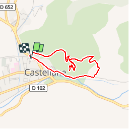
Tour Wandern von 3,5 km verfügbar auf Provence-Alpes-Côte d'Azur, Alpes-de-Haute-Provence, Castellane. Diese Tour wird von lviallet vorgeschlagen.
Beschreibung
Après Moustiers-Ste-Marie, dans les gorges.
Unique vestige de l'ancienne Pétra Castellana, Notre-Dame du Roc offre un panorama remarquable sur Castellane et le Verdon.
Ort
Land:
France
Region :
Provence-Alpes-Côte d'Azur
Abteilung/Provinz :
Alpes-de-Haute-Provence
Kommune :
Castellane
Standort:
Unknown
Gehen Sie:(Dec)
Gehen Sie:(UTM)
299921 ; 4857996 (32T) N.
Kommentare
Touren in der Umgebung
![Tour Wandern Castellane - Sentier des Siréniens - Photo](https://media.geolcdn.com/t/375/260/ext.jpg?maxdim=2&url=https%3A%2F%2Fservices.sitytrail.com%2FGeolivesWS%2FDownloadMedia.ashx%3FTrailID%3D1056050%26Media%3Dfix__20181013150513.jpg)
![Wandern Wandern](https://static1.geolcdn.com/sitytour/trail-icons/101.png)
Sentier des Siréniens
Wandern
Sehr leicht
(1)
Castellane,
Provence-Alpes-Côte d'Azur,
Alpes-de-Haute-Provence,
France
![](/images/other/stat-length.png)
3,8 km | 5,5 km-effort
1h 9min
![](https://static1.geolcdn.com/siteimages/upload/files/16400158638029165_repeat_loop_refresh_sync_direction_icon.png)
Ja
![Tour Wandern Castellane - cadiere de brandis - Photo](https://media.geolcdn.com/t/375/260/ext.jpg?maxdim=2&url=https%3A%2F%2Fservices.sitytrail.com%2FGeolivesWS%2FDownloadMedia.ashx%3FTrailID%3D138609%26Media%3D20120712104941.jpeg)
![Wandern Wandern](https://static1.geolcdn.com/sitytour/trail-icons/101.png)
cadiere de brandis
Wandern
Sehr leicht
(1)
Castellane,
Provence-Alpes-Côte d'Azur,
Alpes-de-Haute-Provence,
France
![](/images/other/stat-length.png)
8,9 km | 14,6 km-effort
2h 27min
![](https://static1.geolcdn.com/siteimages/upload/files/16400158638029165_repeat_loop_refresh_sync_direction_icon.png)
Nein
![Mountainbike Mountainbike](https://static1.geolcdn.com/sitytour/trail-icons/202.png)
vtt-de-castellane-au-lac-de-castillon
Mountainbike
Sehr leicht
Castellane,
Provence-Alpes-Côte d'Azur,
Alpes-de-Haute-Provence,
France
![](/images/other/stat-length.png)
14,7 km | 19,5 km-effort
Unbekannt
![](https://static1.geolcdn.com/siteimages/upload/files/16400158638029165_repeat_loop_refresh_sync_direction_icon.png)
Ja
![Tour Wandern Castellane - Cadières de Brandis version Light - Photo](https://media.geolcdn.com/t/375/260/605f0da0-c80c-45b5-84af-1edbec3be1ea.jpg&format=jpg&maxdim=2)
![Wandern Wandern](https://static1.geolcdn.com/sitytour/trail-icons/101.png)
Cadières de Brandis version Light
Wandern
Schwierig
Castellane,
Provence-Alpes-Côte d'Azur,
Alpes-de-Haute-Provence,
France
![](/images/other/stat-length.png)
9,2 km | 15,4 km-effort
3h 0min
![](https://static1.geolcdn.com/siteimages/upload/files/16400158638029165_repeat_loop_refresh_sync_direction_icon.png)
Ja
![Tour Wandern Castellane - Cadières de Brandis - Photo](https://media.geolcdn.com/t/375/260/ext.jpg?maxdim=2&url=https%3A%2F%2Fstatic1.geolcdn.com%2Fsiteimages%2Fupload%2Ffiles%2F1553511878bg_sport_marche.png)
![Wandern Wandern](https://static1.geolcdn.com/sitytour/trail-icons/101.png)
Cadières de Brandis
Wandern
Medium
(1)
Castellane,
Provence-Alpes-Côte d'Azur,
Alpes-de-Haute-Provence,
France
![](/images/other/stat-length.png)
10,7 km | 18,4 km-effort
3h 51min
![](https://static1.geolcdn.com/siteimages/upload/files/16400158638029165_repeat_loop_refresh_sync_direction_icon.png)
Ja
![Tour Wandern Castellane - la colle cadieres de brandis 20kms 1086m - Photo](https://media.geolcdn.com/t/375/260/d2556f93-acba-4de2-87f5-52e88683f173.jpg&format=jpg&maxdim=2)
![Wandern Wandern](https://static1.geolcdn.com/sitytour/trail-icons/101.png)
la colle cadieres de brandis 20kms 1086m
Wandern
Medium
(1)
Castellane,
Provence-Alpes-Côte d'Azur,
Alpes-de-Haute-Provence,
France
![](/images/other/stat-length.png)
19,6 km | 33 km-effort
7h 44min
![](https://static1.geolcdn.com/siteimages/upload/files/16400158638029165_repeat_loop_refresh_sync_direction_icon.png)
Ja
![Tour Wandern Castellane - castellane - Photo](https://media.geolcdn.com/t/375/260/ef06b05b-8807-4e7d-9459-ab4108fe9a75.jpg&format=jpg&maxdim=2)
![Wandern Wandern](https://static1.geolcdn.com/sitytour/trail-icons/101.png)
castellane
Wandern
Medium
Castellane,
Provence-Alpes-Côte d'Azur,
Alpes-de-Haute-Provence,
France
![](/images/other/stat-length.png)
4,7 km | 8 km-effort
1h 26min
![](https://static1.geolcdn.com/siteimages/upload/files/16400158638029165_repeat_loop_refresh_sync_direction_icon.png)
Ja
![Tour Wandern Castellane - La Colle : Cadières de Brandis - Photo](https://media.geolcdn.com/t/375/260/c8417374-dd6d-4c42-aafc-c75ff17f0957.jpg&format=jpg&maxdim=2)
![Wandern Wandern](https://static1.geolcdn.com/sitytour/trail-icons/101.png)
La Colle : Cadières de Brandis
Wandern
Schwierig
Castellane,
Provence-Alpes-Côte d'Azur,
Alpes-de-Haute-Provence,
France
![](/images/other/stat-length.png)
17,5 km | 30 km-effort
6h 54min
![](https://static1.geolcdn.com/siteimages/upload/files/16400158638029165_repeat_loop_refresh_sync_direction_icon.png)
Ja
![Tour Wandern Demandolx - Demandolx cremon 1000m 16kms - Photo](https://media.geolcdn.com/t/375/260/b7cd96b9-33eb-4641-9b29-6e612e91eee7.jpg&format=jpg&maxdim=2)
![Wandern Wandern](https://static1.geolcdn.com/sitytour/trail-icons/101.png)
Demandolx cremon 1000m 16kms
Wandern
Sehr schwierig
Demandolx,
Provence-Alpes-Côte d'Azur,
Alpes-de-Haute-Provence,
France
![](/images/other/stat-length.png)
14,8 km | 27 km-effort
8h 5min
![](https://static1.geolcdn.com/siteimages/upload/files/16400158638029165_repeat_loop_refresh_sync_direction_icon.png)
Ja