![](/images/other/stat-length.png)
![Tour Wandern Forcalquier - Forcalquier: Les Mourres - 6.4km 209m - Photo](https://media.geolcdn.com/t/1900/400/ext.pjpeg?maxdim=2&url=https%3A%2F%2Fservices.sitytrail.com%2FGeolivesWS%2FDownloadMedia.ashx%3FTrailID%3D511906%26Media%3Dc847d10f-a83b-46c6-8bcc-8ec9bf2fc288.jpg)
Forcalquier: Les Mourres - 6.4km 209m
lviallet
Benutzer
![Länge](/images/other/stat-length.png)
Länge
6,4 km
![Maximale Höhe](https://static1.geolcdn.com/siteimages/upload/files/1508320355ic_sort_altitude_max_24dp.png)
Maximale Höhe
731 m
![Positive Höhendifferenz](https://static1.geolcdn.com/siteimages/upload/files/1508320355ic_sort_den_pos_24dp.png)
Positive Höhendifferenz
209 m
![Km-Effort](/images/other/stat-length.png)
Km-Effort
9,2 km
![Min. Höhe](https://static1.geolcdn.com/siteimages/upload/files/1508320355ic_sort_altitude_min_24dp.png)
Min. Höhe
531 m
![Negative Höhendifferenz](https://static1.geolcdn.com/siteimages/upload/files/1508320355ic_sort_den_neg_24dp.png)
Negative Höhendifferenz
211 m
![Boucle](https://static1.geolcdn.com/siteimages/upload/files/16400158638029165_repeat_loop_refresh_sync_direction_icon.png)
Boucle
Ja
Erstellungsdatum :
2016-09-02 00:00:00.0
Letzte Änderung :
2022-01-02 09:04:14.183
![Wandern](https://static1.geolcdn.com/sitytour/trail-icons/101.png)
1h54
Schwierigkeit : Einfach
![Scannen Sie diesen QR-Code, um die Tour in der SityTrail-Anwendung zu öffnen](https://capi.geolives.com/qq0zvz2zws4bq2lad0pu/sitytour/trails/511906/qr.png?size=200)
Kostenlosegpshiking-Anwendung
Über SityTrail
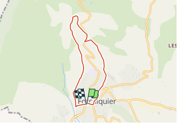
Tour Wandern von 6,4 km verfügbar auf Provence-Alpes-Côte d'Azur, Alpes-de-Haute-Provence, Forcalquier. Diese Tour wird von lviallet vorgeschlagen.
Beschreibung
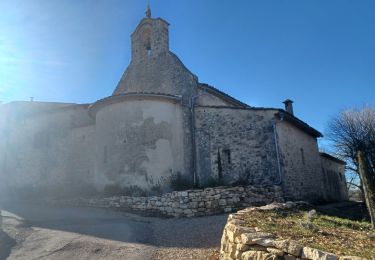
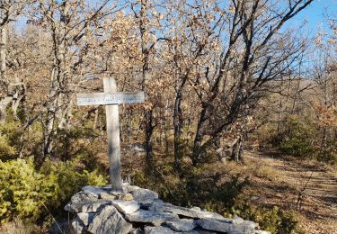
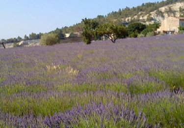
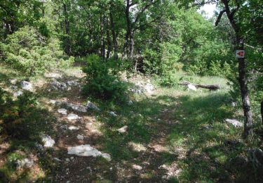
Départ: Forcalquier.
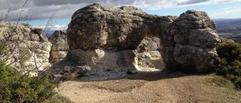
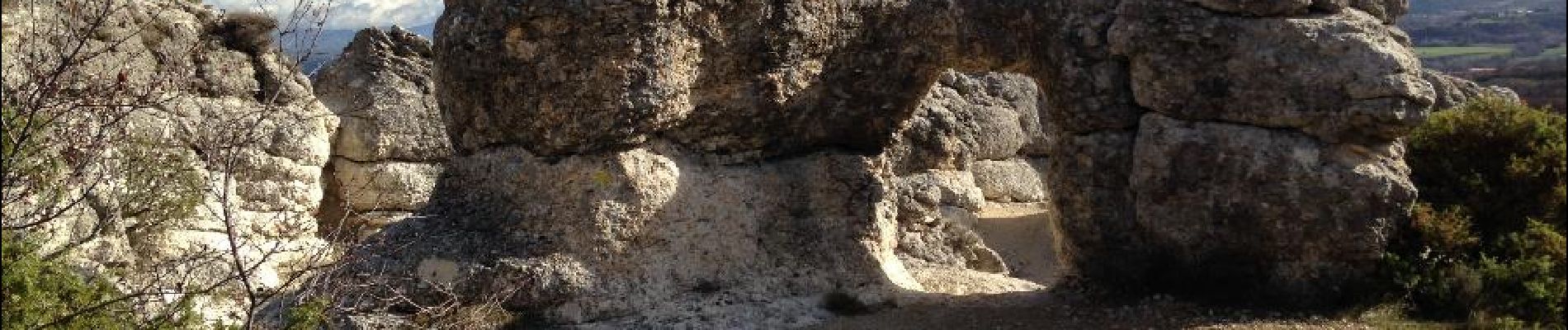
Paysage ruiniforme. Erosions marno-calcaires du miocène à sculter sur le mode des cheminées de fées un paysage de rochers en forme de têtes, de champignons, d'arches ou de ponts.
Ort
Land:
France
Region :
Provence-Alpes-Côte d'Azur
Abteilung/Provinz :
Alpes-de-Haute-Provence
Kommune :
Forcalquier
Standort:
Unknown
Gehen Sie:(Dec)
Gehen Sie:(UTM)
722807 ; 4870941 (31T) N.
Kommentare
Touren in der Umgebung
![Tour Wandern Mane - MANE. Prieuré de Salagon , Pont romain , petit Sauvan , carrières, tour de Pourchere chapelles , ol l s - Photo](https://media.geolcdn.com/t/375/260/d1588e6f-dded-4027-aaae-990874136ea9.jpg&format=jpg&maxdim=2)
![Wandern Wandern](https://static1.geolcdn.com/sitytour/trail-icons/101.png)
MANE. Prieuré de Salagon , Pont romain , petit Sauvan , carrières, tour de P...
Wandern
Medium
(1)
Mane,
Provence-Alpes-Côte d'Azur,
Alpes-de-Haute-Provence,
France
![](/images/other/stat-length.png)
13,2 km | 17,4 km-effort
3h 50min
![](https://static1.geolcdn.com/siteimages/upload/files/16400158638029165_repeat_loop_refresh_sync_direction_icon.png)
Ja
![Tour Wandern Forcalquier - GR6 - Mère des Fontaines - Roche Ruine - Les Mourres - Photo](https://media.geolcdn.com/t/375/260/76cb3b2d-ea42-47ba-83f0-25484645e194.jpg&format=jpg&maxdim=2)
![Wandern Wandern](https://static1.geolcdn.com/sitytour/trail-icons/101.png)
GR6 - Mère des Fontaines - Roche Ruine - Les Mourres
Wandern
Einfach
(1)
Forcalquier,
Provence-Alpes-Côte d'Azur,
Alpes-de-Haute-Provence,
France
![](/images/other/stat-length.png)
18 km | 26 km-effort
4h 42min
![](https://static1.geolcdn.com/siteimages/upload/files/16400158638029165_repeat_loop_refresh_sync_direction_icon.png)
Ja
![Tour Fahrrad Forcalquier - Parcours n°17 - Forcalquier - Photo](https://media.geolcdn.com/t/375/260/ext.jpg?maxdim=2&url=https%3A%2F%2Fservices.sitytrail.com%2FGeolivesWS%2FDownloadMedia.ashx%3FTrailID%3D375418%26Media%3D84c90ab1-7dbd-443e-924d-85d77bb4fdae.jpg)
![Fahrrad Fahrrad](https://static1.geolcdn.com/sitytour/trail-icons/200.png)
Parcours n°17 - Forcalquier
Fahrrad
Einfach
(1)
Forcalquier,
Provence-Alpes-Côte d'Azur,
Alpes-de-Haute-Provence,
France
![](/images/other/stat-length.png)
21 km | 25 km-effort
1h 28min
![](https://static1.geolcdn.com/siteimages/upload/files/16400158638029165_repeat_loop_refresh_sync_direction_icon.png)
Ja
![Tour Wandern Mane - MANE Tours de la laye 3 - Photo](https://media.geolcdn.com/t/375/260/ext.jpg?maxdim=2&url=https%3A%2F%2Fstatic1.geolcdn.com%2Fsiteimages%2Fupload%2Ffiles%2F1553511878bg_sport_marche.png)
![Wandern Wandern](https://static1.geolcdn.com/sitytour/trail-icons/101.png)
MANE Tours de la laye 3
Wandern
Medium
(1)
Mane,
Provence-Alpes-Côte d'Azur,
Alpes-de-Haute-Provence,
France
![](/images/other/stat-length.png)
15,1 km | 22 km-effort
5h 59min
![](https://static1.geolcdn.com/siteimages/upload/files/16400158638029165_repeat_loop_refresh_sync_direction_icon.png)
Ja
![Tour Wandern Mane - 110ter-Mane.Les Ybourgues. sans passer par Chateauneuf. Mane - Photo](https://media.geolcdn.com/t/375/260/ext.jpg?maxdim=2&url=https%3A%2F%2Fservices.sitytrail.com%2FGeolivesWS%2FDownloadMedia.ashx%3FTrailID%3D260790%26Media%3Dfix__20140326084226.jpg)
![Wandern Wandern](https://static1.geolcdn.com/sitytour/trail-icons/101.png)
110ter-Mane.Les Ybourgues. sans passer par Chateauneuf. Mane
Wandern
Medium
(1)
Mane,
Provence-Alpes-Côte d'Azur,
Alpes-de-Haute-Provence,
France
![](/images/other/stat-length.png)
13,2 km | 19,8 km-effort
3h 0min
![](https://static1.geolcdn.com/siteimages/upload/files/16400158638029165_repeat_loop_refresh_sync_direction_icon.png)
Ja
![Tour Mountainbike Forcalquier - La classique du Clot, circuit n°5 - Pays de Forcalquier - Photo](https://media.geolcdn.com/t/375/260/ext.jpg?maxdim=2&url=https%3A%2F%2Fservices.sitytrail.com%2FGeolivesWS%2FDownloadMedia.ashx%3FTrailID%3D214952%26Media%3D15520_2.jpg)
![Mountainbike Mountainbike](https://static1.geolcdn.com/sitytour/trail-icons/202.png)
La classique du Clot, circuit n°5 - Pays de Forcalquier
Mountainbike
Schwierig
(1)
Forcalquier,
Provence-Alpes-Côte d'Azur,
Alpes-de-Haute-Provence,
France
![](/images/other/stat-length.png)
14,7 km | 20 km-effort
2h 0min
![](https://static1.geolcdn.com/siteimages/upload/files/16400158638029165_repeat_loop_refresh_sync_direction_icon.png)
Ja
![Tour Wandern Mane - MANE , pont romain , chapelle S Jean et chapelle Châteauneuf o l s - Photo](https://media.geolcdn.com/t/375/260/f11acae6-d29d-4a56-adfa-70f020f219fb.jpg&format=jpg&maxdim=2)
![Wandern Wandern](https://static1.geolcdn.com/sitytour/trail-icons/101.png)
MANE , pont romain , chapelle S Jean et chapelle Châteauneuf o l s
Wandern
Einfach
Mane,
Provence-Alpes-Côte d'Azur,
Alpes-de-Haute-Provence,
France
![](/images/other/stat-length.png)
12,1 km | 16,2 km-effort
3h 1min
![](https://static1.geolcdn.com/siteimages/upload/files/16400158638029165_repeat_loop_refresh_sync_direction_icon.png)
Ja
![Tour Wandern Mane - MANE Saint Michel Observatoire o - Photo](https://media.geolcdn.com/t/375/260/39e7d3b3-522e-416b-a76a-f14dbd0f25fb.jpg&format=jpg&maxdim=2)
![Wandern Wandern](https://static1.geolcdn.com/sitytour/trail-icons/101.png)
MANE Saint Michel Observatoire o
Wandern
Schwierig
Mane,
Provence-Alpes-Côte d'Azur,
Alpes-de-Haute-Provence,
France
![](/images/other/stat-length.png)
18,1 km | 24 km-effort
6h 23min
![](https://static1.geolcdn.com/siteimages/upload/files/16400158638029165_repeat_loop_refresh_sync_direction_icon.png)
Ja
![Tour Fahrrad Forcalquier - Le Pays de Forcalquier - Montagne de Lure à vélo - Photo](https://media.geolcdn.com/t/375/260/ext.jpg?maxdim=2&url=https%3A%2F%2Fservices.sitytrail.com%2FGeolivesWS%2FDownloadMedia.ashx%3FTrailID%3D375430%26Media%3D23b539a2-af76-456a-868b-6b919a4761e7.jpg)
![Fahrrad Fahrrad](https://static1.geolcdn.com/sitytour/trail-icons/200.png)
Le Pays de Forcalquier - Montagne de Lure à vélo
Fahrrad
Medium
Forcalquier,
Provence-Alpes-Côte d'Azur,
Alpes-de-Haute-Provence,
France
![](/images/other/stat-length.png)
81 km | 99 km-effort
5h 36min
![](https://static1.geolcdn.com/siteimages/upload/files/16400158638029165_repeat_loop_refresh_sync_direction_icon.png)
Ja
très joli site les rochers des Mourres