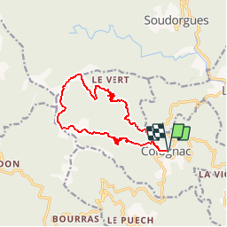
![](/images/other/stat-length.png)
![Tour Wandern Colognac - colognac camp barrat - Photo](https://media.geolcdn.com/t/1900/400/ext.pjpeg?maxdim=2&url=https%3A%2F%2Fstatic1.geolcdn.com%2Fsiteimages%2Fupload%2Ffiles%2F1553511878bg_sport_marche.png)
colognac camp barrat
hvezinet
Benutzer
![Länge](/images/other/stat-length.png)
![Maximale Höhe](https://static1.geolcdn.com/siteimages/upload/files/1508320355ic_sort_altitude_max_24dp.png)
![Positive Höhendifferenz](https://static1.geolcdn.com/siteimages/upload/files/1508320355ic_sort_den_pos_24dp.png)
![Km-Effort](/images/other/stat-length.png)
![Min. Höhe](https://static1.geolcdn.com/siteimages/upload/files/1508320355ic_sort_altitude_min_24dp.png)
![Negative Höhendifferenz](https://static1.geolcdn.com/siteimages/upload/files/1508320355ic_sort_den_neg_24dp.png)
![Boucle](https://static1.geolcdn.com/siteimages/upload/files/16400158638029165_repeat_loop_refresh_sync_direction_icon.png)
![Wandern](https://static1.geolcdn.com/sitytour/trail-icons/101.png)
4h16
Schwierigkeit : Medium
![Scannen Sie diesen QR-Code, um die Tour in der SityTrail-Anwendung zu öffnen](https://capi.geolives.com/qq0zvz2zws4bq2lad0pu/sitytour/trails/490508/qr.png?size=200)
Kostenlosegpshiking-Anwendung
Über SityTrail
Tour Wandern von 12,8 km verfügbar auf Okzitanien, Gard, Colognac. Diese Tour wird von hvezinet vorgeschlagen.
Beschreibung
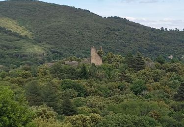
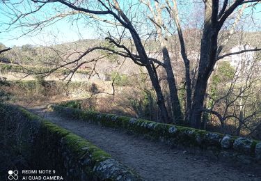
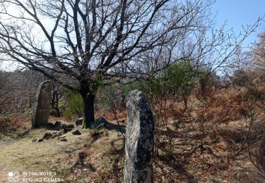
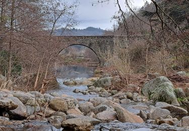
Les drailles et la crete de camp Barrat. On suit le GR6 jusqu'au col des fosses. Au debut le long du ruisseau de coulegne etses jolies cascades. Le chemin monte ensuite en lacets traverse un chemin et continue en echarpe avec de jolies vues. dommage qu'il soit si dégradé et penible a marcher par endroit. On arrive au col des fosses puis oncontinue sur le GR on longe le Gite des fosses et en balcon on rejoint le CAMP BARRAT. Il faut alors prendre a droite un sentier a peine marqué par endroit qui suit globalement la crete vers le nord est. se guider aux balises bleues. A un replat obliquer sud est toujours en crete et avec les balises bleues. le parcours devient plus boisé. la pente s'accentue et la sente balisee bleue debouche sur un chemin.prendre a gauche et descendre plein nord, traverser un ruisseau puis le hameau en ruine de Picard. 300 metres apres le hameau prendre a droite un sentier qui descend en lacet entre des maisons en ruine. il descend sud est a la Poujade. traverser le ruisseau de Bouzon et emprunter le chemin jusqu'à Colognac.
Ort
Kommentare
Touren in der Umgebung
![Tour Wandern Lasalle - Lasalle (la Salendrinque) - Photo](https://media.geolcdn.com/t/375/260/ext.jpg?maxdim=2&url=https%3A%2F%2Fstatic1.geolcdn.com%2Fsiteimages%2Fupload%2Ffiles%2F1553511878bg_sport_marche.png)
![Wandern Wandern](https://static1.geolcdn.com/sitytour/trail-icons/101.png)
Wandern
![](/images/other/stat-length.png)
![](https://static1.geolcdn.com/siteimages/upload/files/16400158638029165_repeat_loop_refresh_sync_direction_icon.png)
![Tour Wandern Soudorgues - Vallée Salindrenque - Photo](https://media.geolcdn.com/t/375/260/cdaa973a-fc3c-410e-b572-e43390419aac.jpg&format=jpg&maxdim=2)
![Wandern Wandern](https://static1.geolcdn.com/sitytour/trail-icons/101.png)
Wandern
![](/images/other/stat-length.png)
![](https://static1.geolcdn.com/siteimages/upload/files/16400158638029165_repeat_loop_refresh_sync_direction_icon.png)
![Tour Wandern Lasalle - LASALLE - SAINTE-CROIX-DE-CADERLE – CALVIAC - 8.3Km - 02h30 - Dénivelé 352 m - Photo](https://media.geolcdn.com/t/375/260/ext.jpg?maxdim=2&url=https%3A%2F%2Fstatic1.geolcdn.com%2Fsiteimages%2Fupload%2Ffiles%2F1553511878bg_sport_marche.png)
![Wandern Wandern](https://static1.geolcdn.com/sitytour/trail-icons/101.png)
Wandern
![](/images/other/stat-length.png)
![](https://static1.geolcdn.com/siteimages/upload/files/16400158638029165_repeat_loop_refresh_sync_direction_icon.png)
![Tour Wandern Soudorgues - 30 le mauripe 12/01/25 - Photo](https://media.geolcdn.com/t/375/260/c58da66e-da90-432e-9b8e-79a3a5c374cc.jpg&format=jpg&maxdim=2)
![Wandern Wandern](https://static1.geolcdn.com/sitytour/trail-icons/101.png)
Wandern
![](/images/other/stat-length.png)
![](https://static1.geolcdn.com/siteimages/upload/files/16400158638029165_repeat_loop_refresh_sync_direction_icon.png)
![Tour Wandern Sainte-Croix-de-Caderle - Sainte croix de caderne - Photo](https://media.geolcdn.com/t/375/260/ba9120ca-f6c8-4e17-a730-5e8fa60dbcd0.jpg&format=jpg&maxdim=2)
![Wandern Wandern](https://static1.geolcdn.com/sitytour/trail-icons/101.png)
Wandern
![](/images/other/stat-length.png)
![](https://static1.geolcdn.com/siteimages/upload/files/16400158638029165_repeat_loop_refresh_sync_direction_icon.png)
![Tour Zu Fuß Colognac - 30 du Cayrel au Camp Barrat 20/02/24 - Photo](https://media.geolcdn.com/t/375/260/db46be15-0ade-41ce-a4c3-6381b880347f.jpg&format=jpg&maxdim=2)
![Zu Fuß Zu Fuß](https://static1.geolcdn.com/sitytour/trail-icons/100.png)
Zu Fuß
![](/images/other/stat-length.png)
![](https://static1.geolcdn.com/siteimages/upload/files/16400158638029165_repeat_loop_refresh_sync_direction_icon.png)
![Tour Wandern Lasalle - Lasalle - Photo](https://media.geolcdn.com/t/375/260/f5798f1a-39ae-4247-a0e3-4c9a96cfa841.jpg&format=jpg&maxdim=2)
![Wandern Wandern](https://static1.geolcdn.com/sitytour/trail-icons/101.png)
Wandern
![](/images/other/stat-length.png)
![](https://static1.geolcdn.com/siteimages/upload/files/16400158638029165_repeat_loop_refresh_sync_direction_icon.png)
![Tour Wandern Lasalle - LaSalle - Photo](https://media.geolcdn.com/t/375/260/7a654ce7-e102-4459-8e43-06423b1a0861.jpg&format=jpg&maxdim=2)
![Wandern Wandern](https://static1.geolcdn.com/sitytour/trail-icons/101.png)
Wandern
![](/images/other/stat-length.png)
![](https://static1.geolcdn.com/siteimages/upload/files/16400158638029165_repeat_loop_refresh_sync_direction_icon.png)
![Tour Wandern Lasalle - vallée Salindrenque autour de Lasalle - Photo](https://media.geolcdn.com/t/375/260/a73dda74-f27d-4781-8977-cf2b7ac09d72.jpg&format=jpg&maxdim=2)
![Wandern Wandern](https://static1.geolcdn.com/sitytour/trail-icons/101.png)
Wandern
![](/images/other/stat-length.png)
![](https://static1.geolcdn.com/siteimages/upload/files/16400158638029165_repeat_loop_refresh_sync_direction_icon.png)