![](/images/other/stat-length.png)
![Tour Wandern Douarnenez - PR 32 Chemin de la Sardine - Photo](https://media.geolcdn.com/t/1900/400/ext.pjpeg?maxdim=2&url=https%3A%2F%2Fstatic1.geolcdn.com%2Fsiteimages%2Fupload%2Ffiles%2F1553511878bg_sport_marche.png)
PR 32 Chemin de la Sardine
CHEVE
Benutzer
![Länge](/images/other/stat-length.png)
Länge
4,3 km
![Maximale Höhe](https://static1.geolcdn.com/siteimages/upload/files/1508320355ic_sort_altitude_max_24dp.png)
Maximale Höhe
30 m
![Positive Höhendifferenz](https://static1.geolcdn.com/siteimages/upload/files/1508320355ic_sort_den_pos_24dp.png)
Positive Höhendifferenz
67 m
![Km-Effort](/images/other/stat-length.png)
Km-Effort
5,1 km
![Min. Höhe](https://static1.geolcdn.com/siteimages/upload/files/1508320355ic_sort_altitude_min_24dp.png)
Min. Höhe
0 m
![Negative Höhendifferenz](https://static1.geolcdn.com/siteimages/upload/files/1508320355ic_sort_den_neg_24dp.png)
Negative Höhendifferenz
60 m
![Boucle](https://static1.geolcdn.com/siteimages/upload/files/16400158638029165_repeat_loop_refresh_sync_direction_icon.png)
Boucle
Nein
Erstellungsdatum :
2016-01-13 00:00:00.0
Letzte Änderung :
2016-01-13 00:00:00.0
![Wandern](https://static1.geolcdn.com/sitytour/trail-icons/101.png)
1h14
Schwierigkeit : Sehr leicht
![Scannen Sie diesen QR-Code, um die Tour in der SityTrail-Anwendung zu öffnen](https://capi.geolives.com/qq0zvz2zws4bq2lad0pu/sitytour/trails/489228/qr.png?size=200)
Kostenlosegpshiking-Anwendung
Über SityTrail
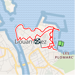
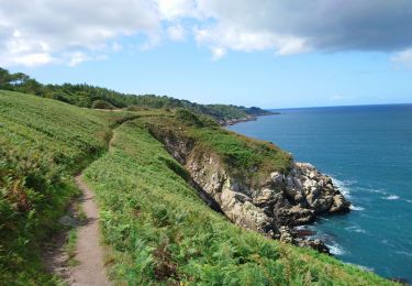
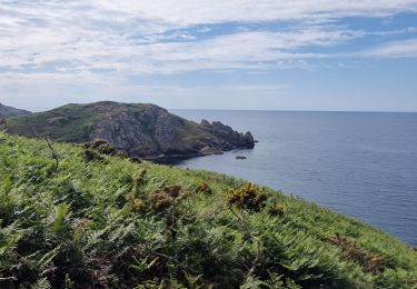
Tour Wandern von 4,3 km verfügbar auf Bretagne, Finistère, Douarnenez. Diese Tour wird von CHEVE vorgeschlagen.
Beschreibung
PR 32, du topo guide 294.
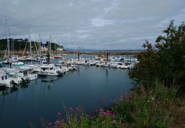
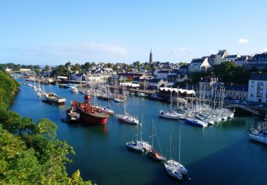
Chemin de la sardine à Douarnenez permettant de cheminer au coeur de la ville de Douarnenez en passant par les deux ports, Le Rosmeur et le port musée du Port RHU
Ort
Land:
France
Region :
Bretagne
Abteilung/Provinz :
Finistère
Kommune :
Douarnenez
Standort:
Unknown
Gehen Sie:(Dec)
Gehen Sie:(UTM)
401456 ; 5327459 (30U) N.
Kommentare
Touren in der Umgebung
![Tour Wandern Douarnenez - Douarnenez - GR34 AR les Roches Blanches Pointe de la Jument - 9.3km 250m 3h30 - 2019 09 01 - Photo](https://media.geolcdn.com/t/375/260/ab448e69-f6b6-4c7f-80fa-8b9533bb0920.jpg&format=jpg&maxdim=2)
![Wandern Wandern](https://static1.geolcdn.com/sitytour/trail-icons/101.png)
Douarnenez - GR34 AR les Roches Blanches Pointe de la Jument - 9.3km 250m 3h...
Wandern
Medium
(1)
Douarnenez,
Bretagne,
Finistère,
France
![](/images/other/stat-length.png)
9,3 km | 12,6 km-effort
3h 30min
![](https://static1.geolcdn.com/siteimages/upload/files/16400158638029165_repeat_loop_refresh_sync_direction_icon.png)
Ja
![Tour Wandern Douarnenez - TREK RCY GR34 2022 j2 Douarnenez- Beuzec - Photo](https://media.geolcdn.com/t/375/260/8fdd798e-9630-4ffb-bea5-9ee3ec61b3a8.jpg&format=jpg&maxdim=2)
![Wandern Wandern](https://static1.geolcdn.com/sitytour/trail-icons/101.png)
TREK RCY GR34 2022 j2 Douarnenez- Beuzec
Wandern
Medium
Douarnenez,
Bretagne,
Finistère,
France
![](/images/other/stat-length.png)
23 km | 30 km-effort
6h 32min
![](https://static1.geolcdn.com/siteimages/upload/files/16400158638029165_repeat_loop_refresh_sync_direction_icon.png)
Nein
![Tour Wandern Douarnenez - Trek RCY GR 34 2022- journée 1 Balade Douarnenez - Photo](https://media.geolcdn.com/t/375/260/e6241847-f9f8-4845-8061-377f37ea1e75.jpg&format=jpg&maxdim=2)
![Wandern Wandern](https://static1.geolcdn.com/sitytour/trail-icons/101.png)
Trek RCY GR 34 2022- journée 1 Balade Douarnenez
Wandern
Sehr leicht
Douarnenez,
Bretagne,
Finistère,
France
![](/images/other/stat-length.png)
10,9 km | 13,3 km-effort
2h 33min
![](https://static1.geolcdn.com/siteimages/upload/files/16400158638029165_repeat_loop_refresh_sync_direction_icon.png)
Nein
![Tour Zu Fuß Douarnenez - Le chemin de la sardine - Photo](https://media.geolcdn.com/t/375/260/9ce746a4-512e-4653-b738-0ff8fd3fd82c.jpeg&format=jpg&maxdim=2)
![Zu Fuß Zu Fuß](https://static1.geolcdn.com/sitytour/trail-icons/100.png)
Le chemin de la sardine
Zu Fuß
Einfach
Douarnenez,
Bretagne,
Finistère,
France
![](/images/other/stat-length.png)
4,1 km | 5 km-effort
1h 8min
![](https://static1.geolcdn.com/siteimages/upload/files/16400158638029165_repeat_loop_refresh_sync_direction_icon.png)
Nein
![Tour Wandern Douarnenez - Douarnenez - GR34 du port de plaisance aux Roches Blanches - 9.7km 165m 2h30 - 2019 09 06 - Photo](https://media.geolcdn.com/t/375/260/d1eb9c88-a75c-496a-a8ef-0db250d9eb67.jpg&format=jpg&maxdim=2)
![Wandern Wandern](https://static1.geolcdn.com/sitytour/trail-icons/101.png)
Douarnenez - GR34 du port de plaisance aux Roches Blanches - 9.7km 165m 2h30 ...
Wandern
Einfach
Douarnenez,
Bretagne,
Finistère,
France
![](/images/other/stat-length.png)
9,7 km | 11,9 km-effort
2h 30min
![](https://static1.geolcdn.com/siteimages/upload/files/16400158638029165_repeat_loop_refresh_sync_direction_icon.png)
Ja
![Tour Wandern Douarnenez - Douarnenez - du Port Rhu - 5.8km 115m 1h45 - 2019 09 01 - Photo](https://media.geolcdn.com/t/375/260/28ac96a0-9369-40eb-a4d8-7b2ede676873.jpg&format=jpg&maxdim=2)
![Wandern Wandern](https://static1.geolcdn.com/sitytour/trail-icons/101.png)
Douarnenez - du Port Rhu - 5.8km 115m 1h45 - 2019 09 01
Wandern
Sehr leicht
(1)
Douarnenez,
Bretagne,
Finistère,
France
![](/images/other/stat-length.png)
5,8 km | 7,3 km-effort
1h 45min
![](https://static1.geolcdn.com/siteimages/upload/files/16400158638029165_repeat_loop_refresh_sync_direction_icon.png)
Ja
![Tour Wandern Douarnenez - GR34 Douarnenez-- Pors Peron - Photo](https://media.geolcdn.com/t/375/260/55c8cb23-826e-4476-a89b-d5fdee2975ce.jpg&format=jpg&maxdim=2)
![Wandern Wandern](https://static1.geolcdn.com/sitytour/trail-icons/101.png)
GR34 Douarnenez-- Pors Peron
Wandern
Sehr schwierig
Douarnenez,
Bretagne,
Finistère,
France
![](/images/other/stat-length.png)
23 km | 29 km-effort
6h 29min
![](https://static1.geolcdn.com/siteimages/upload/files/16400158638029165_repeat_loop_refresh_sync_direction_icon.png)
Nein
![Tour Wandern Douarnenez - DOUARNENEZ - Photo](https://media.geolcdn.com/t/375/260/669ff4fd-0def-4571-a23c-23ec26be7050.jpg&format=jpg&maxdim=2)
![Wandern Wandern](https://static1.geolcdn.com/sitytour/trail-icons/101.png)
DOUARNENEZ
Wandern
Sehr schwierig
Douarnenez,
Bretagne,
Finistère,
France
![](/images/other/stat-length.png)
22 km | 27 km-effort
5h 7min
![](https://static1.geolcdn.com/siteimages/upload/files/16400158638029165_repeat_loop_refresh_sync_direction_icon.png)
Ja
![Tour Wandern Douarnenez - TREK RCY GR34 2022 J1 Balade du soir - Photo](https://media.geolcdn.com/t/375/260/6afdc80c-f966-4c00-935f-4079c9c4567d.jpg&format=jpg&maxdim=2)
![Wandern Wandern](https://static1.geolcdn.com/sitytour/trail-icons/101.png)
TREK RCY GR34 2022 J1 Balade du soir
Wandern
Sehr leicht
Douarnenez,
Bretagne,
Finistère,
France
![](/images/other/stat-length.png)
6,5 km | 8,5 km-effort
1h 22min
![](https://static1.geolcdn.com/siteimages/upload/files/16400158638029165_repeat_loop_refresh_sync_direction_icon.png)
Ja