![](/images/other/stat-length.png)
![Tour Wandern Bex - Bex, Vallon de Nant - Photo](https://media.geolcdn.com/t/1900/400/ext.pjpeg?maxdim=2&url=https%3A%2F%2Fstatic1.geolcdn.com%2Fsiteimages%2Fupload%2Ffiles%2F1553511878bg_sport_marche.png)
Bex, Vallon de Nant
rpf
Benutzer
![Länge](/images/other/stat-length.png)
Länge
10 km
![Maximale Höhe](https://static1.geolcdn.com/siteimages/upload/files/1508320355ic_sort_altitude_max_24dp.png)
Maximale Höhe
1699 m
![Positive Höhendifferenz](https://static1.geolcdn.com/siteimages/upload/files/1508320355ic_sort_den_pos_24dp.png)
Positive Höhendifferenz
532 m
![Km-Effort](/images/other/stat-length.png)
Km-Effort
17,1 km
![Min. Höhe](https://static1.geolcdn.com/siteimages/upload/files/1508320355ic_sort_altitude_min_24dp.png)
Min. Höhe
1258 m
![Negative Höhendifferenz](https://static1.geolcdn.com/siteimages/upload/files/1508320355ic_sort_den_neg_24dp.png)
Negative Höhendifferenz
532 m
![Boucle](https://static1.geolcdn.com/siteimages/upload/files/16400158638029165_repeat_loop_refresh_sync_direction_icon.png)
Boucle
Ja
Erstellungsdatum :
2014-12-10 00:00:00.0
Letzte Änderung :
2014-12-10 00:00:00.0
![Wandern](https://static1.geolcdn.com/sitytour/trail-icons/101.png)
4h30
Schwierigkeit : Unbekannt
![Scannen Sie diesen QR-Code, um die Tour in der SityTrail-Anwendung zu öffnen](https://capi.geolives.com/qq0zvz2zws4bq2lad0pu/sitytour/trails/48748/qr.png?size=200)
Kostenlosegpshiking-Anwendung
Über SityTrail
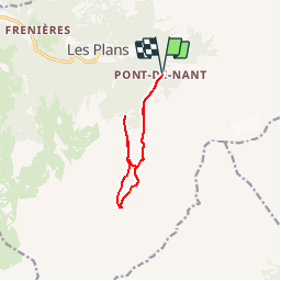
Tour Wandern von 10 km verfügbar auf Waadt, District d'Aigle, Bex. Diese Tour wird von rpf vorgeschlagen.
Beschreibung
Sous les parois rocheuses des Muverans et de la Dent de Morcles... Une réserve naturelle... un jardin alpin, la Thomasia... Des ruisseaux, des pierriers, des forêts, une riche végétation... Tous les ingrédients pour une journée réussie !
Une balade de " www.toprando.ch "
Ort
Land:
Switzerland
Region :
Waadt
Abteilung/Provinz :
District d'Aigle
Kommune :
Bex
Standort:
Unknown
Gehen Sie:(Dec)
Gehen Sie:(UTM)
354374 ; 5123762 (32T) N.
Kommentare
Touren in der Umgebung
![Tour Wandern Bex - Tour du miroir d'Argentine - Photo](https://media.geolcdn.com/t/375/260/a11a4556-d584-4f15-acfa-cb865f305df7.jpg&format=jpg&maxdim=2)
![Wandern Wandern](https://static1.geolcdn.com/sitytour/trail-icons/101.png)
Tour du miroir d'Argentine
Wandern
Sehr schwierig
Bex,
Waadt,
District d'Aigle,
Switzerland
![](/images/other/stat-length.png)
16,8 km | 30 km-effort
7h 5min
![](https://static1.geolcdn.com/siteimages/upload/files/16400158638029165_repeat_loop_refresh_sync_direction_icon.png)
Ja
![Tour Wandern Olun - st_bg_villars1 - Photo](https://media.geolcdn.com/t/375/260/ext.jpg?maxdim=2&url=https%3A%2F%2Fstatic1.geolcdn.com%2Fsiteimages%2Fupload%2Ffiles%2F1553511878bg_sport_marche.png)
![Wandern Wandern](https://static1.geolcdn.com/sitytour/trail-icons/101.png)
st_bg_villars1
Wandern
Sehr leicht
Olun,
Waadt,
District d'Aigle,
Switzerland
![](/images/other/stat-length.png)
5,6 km | 8,3 km-effort
Unbekannt
![](https://static1.geolcdn.com/siteimages/upload/files/16400158638029165_repeat_loop_refresh_sync_direction_icon.png)
Nein
![Tour Wandern Bex - Bex (Genferseegebiet) - Photo](https://media.geolcdn.com/t/375/260/ext.jpg?maxdim=2&url=https%3A%2F%2Fstatic1.geolcdn.com%2Fsiteimages%2Fupload%2Ffiles%2F1553511878bg_sport_marche.png)
![Wandern Wandern](https://static1.geolcdn.com/sitytour/trail-icons/101.png)
Bex (Genferseegebiet)
Wandern
Sehr leicht
Bex,
Waadt,
District d'Aigle,
Switzerland
![](/images/other/stat-length.png)
10,5 km | 18,6 km-effort
5h 55min
![](https://static1.geolcdn.com/siteimages/upload/files/16400158638029165_repeat_loop_refresh_sync_direction_icon.png)
Ja
![Tour Mountainbike Olun - Bike32918 - Photo](https://media.geolcdn.com/t/375/260/ext.jpg?maxdim=2&url=https%3A%2F%2Fstatic1.geolcdn.com%2Fsiteimages%2Fupload%2Ffiles%2F1524743154velo.jpg)
![Mountainbike Mountainbike](https://static1.geolcdn.com/sitytour/trail-icons/202.png)
Bike32918
Mountainbike
Sehr leicht
Olun,
Waadt,
District d'Aigle,
Switzerland
![](/images/other/stat-length.png)
22 km | 35 km-effort
Unbekannt
![](https://static1.geolcdn.com/siteimages/upload/files/16400158638029165_repeat_loop_refresh_sync_direction_icon.png)
Ja
![Tour Laufen Gryon - Mxalps - Photo](https://media.geolcdn.com/t/375/260/ext.jpg?maxdim=2&url=https%3A%2F%2Fstatic1.geolcdn.com%2Fsiteimages%2Fupload%2Ffiles%2F1524743154running.jpg)
![Laufen Laufen](https://static1.geolcdn.com/sitytour/trail-icons/103.png)
Mxalps
Laufen
Schwierig
Gryon,
Waadt,
District d'Aigle,
Switzerland
![](/images/other/stat-length.png)
61 km | 116 km-effort
10h 0min
![](https://static1.geolcdn.com/siteimages/upload/files/16400158638029165_repeat_loop_refresh_sync_direction_icon.png)
Nein
![Tour Laufen Gryon - Mxalps - Photo](https://media.geolcdn.com/t/375/260/ext.jpg?maxdim=2&url=https%3A%2F%2Fstatic1.geolcdn.com%2Fsiteimages%2Fupload%2Ffiles%2F1524743154running.jpg)
![Laufen Laufen](https://static1.geolcdn.com/sitytour/trail-icons/103.png)
Mxalps
Laufen
Schwierig
Gryon,
Waadt,
District d'Aigle,
Switzerland
![](/images/other/stat-length.png)
61 km | 116 km-effort
Unbekannt
![](https://static1.geolcdn.com/siteimages/upload/files/16400158638029165_repeat_loop_refresh_sync_direction_icon.png)
Nein
![Tour Wandern Lavey-Morcles - Morcles, Pointe des Martinets - Photo](https://media.geolcdn.com/t/375/260/ext.jpg?maxdim=2&url=https%3A%2F%2Fstatic1.geolcdn.com%2Fsiteimages%2Fupload%2Ffiles%2F1553511878bg_sport_marche.png)
![Wandern Wandern](https://static1.geolcdn.com/sitytour/trail-icons/101.png)
Morcles, Pointe des Martinets
Wandern
Sehr leicht
Lavey-Morcles,
Waadt,
District d'Aigle,
Switzerland
![](/images/other/stat-length.png)
9,4 km | 22 km-effort
6h 30min
![](https://static1.geolcdn.com/siteimages/upload/files/16400158638029165_repeat_loop_refresh_sync_direction_icon.png)
Ja
![Tour Wandern Chamoson - Ovronnaz, Les Pointes de Tsérié - Photo](https://media.geolcdn.com/t/375/260/ext.jpg?maxdim=2&url=https%3A%2F%2Fstatic1.geolcdn.com%2Fsiteimages%2Fupload%2Ffiles%2F1553511878bg_sport_marche.png)
![Wandern Wandern](https://static1.geolcdn.com/sitytour/trail-icons/101.png)
Ovronnaz, Les Pointes de Tsérié
Wandern
Sehr leicht
Chamoson,
Wallis,
Gundis,
Switzerland
![](/images/other/stat-length.png)
10,2 km | 23 km-effort
7h 30min
![](https://static1.geolcdn.com/siteimages/upload/files/16400158638029165_repeat_loop_refresh_sync_direction_icon.png)
Ja
![Tour Wandern Chamoson - Ovronnaz, Dent de Chamosentze - Photo](https://media.geolcdn.com/t/375/260/ext.jpg?maxdim=2&url=https%3A%2F%2Fstatic1.geolcdn.com%2Fsiteimages%2Fupload%2Ffiles%2F1553511878bg_sport_marche.png)
![Wandern Wandern](https://static1.geolcdn.com/sitytour/trail-icons/101.png)
Ovronnaz, Dent de Chamosentze
Wandern
Sehr leicht
Chamoson,
Wallis,
Gundis,
Switzerland
![](/images/other/stat-length.png)
6,9 km | 15,4 km-effort
4h 30min
![](https://static1.geolcdn.com/siteimages/upload/files/16400158638029165_repeat_loop_refresh_sync_direction_icon.png)
Ja