![](/images/other/stat-length.png)
![Tour Wandern Villeneuve-de-la-Raho - 66 VILLENEUVE-DE-LA-RAHO - grand tour périphérique du lac par les lignes de crêtes - Photo](https://media.geolcdn.com/t/1900/400/ext.pjpeg?maxdim=2&url=https%3A%2F%2Fstatic1.geolcdn.com%2Fsiteimages%2Fupload%2Ffiles%2F1553511878bg_sport_marche.png)
66 VILLENEUVE-DE-LA-RAHO - grand tour périphérique du lac par les lignes de crêtes
jeff66
Benutzer
![Länge](/images/other/stat-length.png)
![Maximale Höhe](https://static1.geolcdn.com/siteimages/upload/files/1508320355ic_sort_altitude_max_24dp.png)
![Positive Höhendifferenz](https://static1.geolcdn.com/siteimages/upload/files/1508320355ic_sort_den_pos_24dp.png)
![Km-Effort](/images/other/stat-length.png)
![Min. Höhe](https://static1.geolcdn.com/siteimages/upload/files/1508320355ic_sort_altitude_min_24dp.png)
![Negative Höhendifferenz](https://static1.geolcdn.com/siteimages/upload/files/1508320355ic_sort_den_neg_24dp.png)
![Boucle](https://static1.geolcdn.com/siteimages/upload/files/16400158638029165_repeat_loop_refresh_sync_direction_icon.png)
![Wandern](https://static1.geolcdn.com/sitytour/trail-icons/101.png)
1h44
Schwierigkeit : Einfach
![Scannen Sie diesen QR-Code, um die Tour in der SityTrail-Anwendung zu öffnen](https://capi.geolives.com/qq0zvz2zws4bq2lad0pu/sitytour/trails/477197/qr.png?size=200)
Kostenlosegpshiking-Anwendung
Über SityTrail
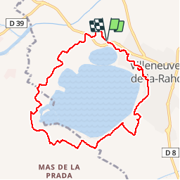
Tour Wandern von 10 km verfügbar auf Okzitanien, Ostpyrenäen, Villeneuve-de-la-Raho. Diese Tour wird von jeff66 vorgeschlagen.
Beschreibung
66 VILLENEUVE-DE-LA-RAHO parking du lac côté Mas Richemont, emprunter la RD39, puis prendre la route en direction de la base nautique - prendre à droite le chemin de terre qui monte vers la crête - réserve écologique - domaine monplaisir propriétaire Joseph Puech - Vulpillères - la Llantia - els Estanyots - stade André Sanac, salle polyvalente, boulodrome, tennis club - quartier de val Marie - ancien stade - la colomina - quartier le val des vignes - rues Joseph Cazeilles, des sports, du Château d'Eau, espace jean Malé, rue de la tramontane,
Cimetiere, table d'orientation. Rue Gustave Violet, avenue du 8 Mai, rues du général Leclerc et du maréchal Joffre, pinède, traverser la RD39 pour arriver au parking
Ort
Kommentare
Touren in der Umgebung
![Tour Quad Montescot - Villeneuve-de-la-Raho-Collioure (Septembre/Juin) - Photo](https://media.geolcdn.com/t/375/260/4ff70784-96c3-45ae-a310-36bc0ac2c85e.jpg&format=jpg&maxdim=2)
![Quad Quad](https://static1.geolcdn.com/sitytour/trail-icons/404.png)
Quad
![](/images/other/stat-length.png)
![](https://static1.geolcdn.com/siteimages/upload/files/16400158638029165_repeat_loop_refresh_sync_direction_icon.png)
![Tour Wandern Montescot - 66 VILLENEUVE-DE-LA-RAHO grand tour du lac en Sens horaire - Photo](https://media.geolcdn.com/t/375/260/ext.jpg?maxdim=2&url=https%3A%2F%2Fservices.sitytrail.com%2FGeolivesWS%2FDownloadMedia.ashx%3FTrailID%3D526864%26Media%3D20160209171243.jpg)
![Wandern Wandern](https://static1.geolcdn.com/sitytour/trail-icons/101.png)
Wandern
![](/images/other/stat-length.png)
![](https://static1.geolcdn.com/siteimages/upload/files/16400158638029165_repeat_loop_refresh_sync_direction_icon.png)
![Tour Wandern Théza - 66 THEZA - CORNEILLA-DEL-VERCOL - Photo](https://media.geolcdn.com/t/375/260/ext.jpg?maxdim=2&url=https%3A%2F%2Fservices.sitytrail.com%2FGeolivesWS%2FDownloadMedia.ashx%3FTrailID%3D460837%26Media%3D20150818162338.jpg)
![Wandern Wandern](https://static1.geolcdn.com/sitytour/trail-icons/101.png)
Wandern
![](/images/other/stat-length.png)
![](https://static1.geolcdn.com/siteimages/upload/files/16400158638029165_repeat_loop_refresh_sync_direction_icon.png)
![Tour Wandern Saleilles - 66 SALEILLES - St-NAZAIRE, entre FOSSEILLE et REART - Photo](https://media.geolcdn.com/t/375/260/ext.jpg?maxdim=2&url=https%3A%2F%2Fstatic1.geolcdn.com%2Fsiteimages%2Fupload%2Ffiles%2F1553511878bg_sport_marche.png)
![Wandern Wandern](https://static1.geolcdn.com/sitytour/trail-icons/101.png)
Wandern
![](/images/other/stat-length.png)
![](https://static1.geolcdn.com/siteimages/upload/files/16400158638029165_repeat_loop_refresh_sync_direction_icon.png)
![Tour Quad Villeneuve-de-la-Raho - Villeneuve-de-la-Raho-Collioure(Juillet-Aout) - Photo](https://media.geolcdn.com/t/375/260/94b9111a-30bb-4d36-9ee6-84d7d83dae26.jpg&format=jpg&maxdim=2)
![Quad Quad](https://static1.geolcdn.com/sitytour/trail-icons/404.png)
Quad
![](/images/other/stat-length.png)
![](https://static1.geolcdn.com/siteimages/upload/files/16400158638029165_repeat_loop_refresh_sync_direction_icon.png)
![Wandern Wandern](https://static1.geolcdn.com/sitytour/trail-icons/101.png)
Wandern
![](/images/other/stat-length.png)
![](https://static1.geolcdn.com/siteimages/upload/files/16400158638029165_repeat_loop_refresh_sync_direction_icon.png)
![Tour Wandern Corneilla-del-Vercol - thématique mo tescot du 18 02 2023 - Photo](https://media.geolcdn.com/t/375/260/c486579c-e3ee-457f-8014-e2e51dcdf4f6.jpg&format=jpg&maxdim=2)
![Wandern Wandern](https://static1.geolcdn.com/sitytour/trail-icons/101.png)
Wandern
![](/images/other/stat-length.png)
![](https://static1.geolcdn.com/siteimages/upload/files/16400158638029165_repeat_loop_refresh_sync_direction_icon.png)
![Tour Wandern Perpignan - Perpignan - Photo](https://media.geolcdn.com/t/375/260/904ff4bb-4f73-47d8-906f-dc7922d74f80.jpg&format=jpg&maxdim=2)
![Wandern Wandern](https://static1.geolcdn.com/sitytour/trail-icons/101.png)
Wandern
![](/images/other/stat-length.png)
![](https://static1.geolcdn.com/siteimages/upload/files/16400158638029165_repeat_loop_refresh_sync_direction_icon.png)
![Tour Wandern Perpignan - canal Perpignan - Photo](https://media.geolcdn.com/t/375/260/ext.jpg?maxdim=2&url=https%3A%2F%2Fservices.sitytrail.com%2FGeolivesWS%2FDownloadMedia.ashx%3FTrailID%3D745865%26Media%3Dfix__20170316151123.jpg)
![Wandern Wandern](https://static1.geolcdn.com/sitytour/trail-icons/101.png)
Wandern
![](/images/other/stat-length.png)
![](https://static1.geolcdn.com/siteimages/upload/files/16400158638029165_repeat_loop_refresh_sync_direction_icon.png)
très bien. je me suis régalée Sabrinasabrinalx66@gmail.com
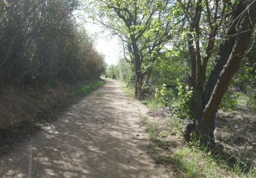
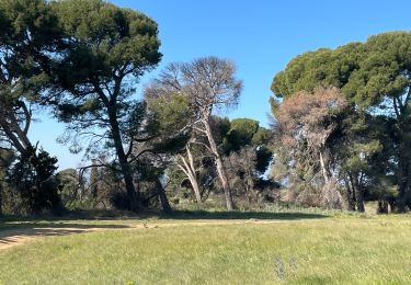
Très belle rando jamais bien loin du lac mais en surplomb. Quelques passages en plein champ.