![](/images/other/stat-length.png)
![Tour Wandern Vienne - Vienne est - 10 km - 273 m de dénivelé - 3h30 - Photo](https://media.geolcdn.com/t/1900/400/ext.pjpeg?maxdim=2&url=https%3A%2F%2Fstatic1.geolcdn.com%2Fsiteimages%2Fupload%2Ffiles%2F1553511878bg_sport_marche.png)
Vienne est - 10 km - 273 m de dénivelé - 3h30
Clubléorando
Benutzer
![Länge](/images/other/stat-length.png)
Länge
10,4 km
![Maximale Höhe](https://static1.geolcdn.com/siteimages/upload/files/1508320355ic_sort_altitude_max_24dp.png)
Maximale Höhe
395 m
![Positive Höhendifferenz](https://static1.geolcdn.com/siteimages/upload/files/1508320355ic_sort_den_pos_24dp.png)
Positive Höhendifferenz
273 m
![Km-Effort](/images/other/stat-length.png)
Km-Effort
14 km
![Min. Höhe](https://static1.geolcdn.com/siteimages/upload/files/1508320355ic_sort_altitude_min_24dp.png)
Min. Höhe
153 m
![Negative Höhendifferenz](https://static1.geolcdn.com/siteimages/upload/files/1508320355ic_sort_den_neg_24dp.png)
Negative Höhendifferenz
272 m
![Boucle](https://static1.geolcdn.com/siteimages/upload/files/16400158638029165_repeat_loop_refresh_sync_direction_icon.png)
Boucle
Ja
Erstellungsdatum :
2015-09-13 00:00:00.0
Letzte Änderung :
2021-04-06 12:17:49.601
![Wandern](https://static1.geolcdn.com/sitytour/trail-icons/101.png)
3h30
Schwierigkeit : Medium
![Scannen Sie diesen QR-Code, um die Tour in der SityTrail-Anwendung zu öffnen](https://capi.geolives.com/qq0zvz2zws4bq2lad0pu/sitytour/trails/471220/qr.png?size=200)
Kostenlosegpshiking-Anwendung
Über SityTrail
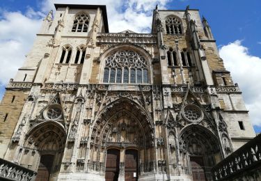
Tour Wandern von 10,4 km verfügbar auf Auvergne-Rhone-Alpen, Isère, Vienne. Diese Tour wird von Clubléorando vorgeschlagen.
Beschreibung
Ballade en boucle au départ de Vienne St Germain puis grimpette direction est, jusqu'au hameau de Manin, et retour par le centre équestre des Charmilles avant de redescendre par le quartier de Coupe Jarret
Ort
Land:
France
Region :
Auvergne-Rhone-Alpen
Abteilung/Provinz :
Isère
Kommune :
Vienne
Standort:
Unknown
Gehen Sie:(Dec)
Gehen Sie:(UTM)
645659 ; 5041661 (31T) N.
Kommentare
Touren in der Umgebung
![Tour Wandern Loire-sur-Rhône - 42 le grisard (vienne) - Photo](https://media.geolcdn.com/t/375/260/c8c552c2-c833-47f9-98c4-fadea207952f.jpg&format=jpg&maxdim=2)
![Wandern Wandern](https://static1.geolcdn.com/sitytour/trail-icons/101.png)
42 le grisard (vienne)
Wandern
Sehr leicht
Loire-sur-Rhône,
Auvergne-Rhone-Alpen,
Rhône,
France
![](/images/other/stat-length.png)
5,6 km | 8,2 km-effort
2h 8min
![](https://static1.geolcdn.com/siteimages/upload/files/16400158638029165_repeat_loop_refresh_sync_direction_icon.png)
Ja
![Tour Zu Fuß Jardin - Jardin - 10,7 km - 255 m de dénivelé - 3h30 - Photo](https://media.geolcdn.com/t/375/260/ext.jpg?maxdim=2&url=https%3A%2F%2Fstatic1.geolcdn.com%2Fsiteimages%2Fupload%2Ffiles%2F1545311037marcheuse_200dpi.jpg)
![Zu Fuß Zu Fuß](https://static1.geolcdn.com/sitytour/trail-icons/100.png)
Jardin - 10,7 km - 255 m de dénivelé - 3h30
Zu Fuß
Medium
(1)
Jardin,
Auvergne-Rhone-Alpen,
Isère,
France
![](/images/other/stat-length.png)
10,7 km | 14,1 km-effort
3h 30min
![](https://static1.geolcdn.com/siteimages/upload/files/16400158638029165_repeat_loop_refresh_sync_direction_icon.png)
Ja
![Tour Mountainbike Serpaize - canyon de Serpaize - Photo](https://media.geolcdn.com/t/375/260/ext.jpg?maxdim=2&url=https%3A%2F%2Fstatic1.geolcdn.com%2Fsiteimages%2Fupload%2Ffiles%2F1524743154velo.jpg)
![Mountainbike Mountainbike](https://static1.geolcdn.com/sitytour/trail-icons/202.png)
canyon de Serpaize
Mountainbike
Einfach
(1)
Serpaize,
Auvergne-Rhone-Alpen,
Isère,
France
![](/images/other/stat-length.png)
13,4 km | 16,8 km-effort
1h 46min
![](https://static1.geolcdn.com/siteimages/upload/files/16400158638029165_repeat_loop_refresh_sync_direction_icon.png)
Ja
![Tour Wandern Saint-Romain-en-Gal - le grisard - Photo](https://media.geolcdn.com/t/375/260/ext.jpg?maxdim=2&url=https%3A%2F%2Fstatic1.geolcdn.com%2Fsiteimages%2Fupload%2Ffiles%2F1553511878bg_sport_marche.png)
![Wandern Wandern](https://static1.geolcdn.com/sitytour/trail-icons/101.png)
le grisard
Wandern
Medium
(1)
Saint-Romain-en-Gal,
Auvergne-Rhone-Alpen,
Rhône,
France
![](/images/other/stat-length.png)
5,3 km | 7,9 km-effort
1h 48min
![](https://static1.geolcdn.com/siteimages/upload/files/16400158638029165_repeat_loop_refresh_sync_direction_icon.png)
Ja
![Tour Wandern Vienne - naïade nocturne digestive à Vienne - Isère - Photo](https://media.geolcdn.com/t/375/260/3e0ddf70-00b3-4de3-8743-20a20b07d4cf.jpg&format=jpg&maxdim=2)
![Wandern Wandern](https://static1.geolcdn.com/sitytour/trail-icons/101.png)
naïade nocturne digestive à Vienne - Isère
Wandern
Sehr leicht
Vienne,
Auvergne-Rhone-Alpen,
Isère,
France
![](/images/other/stat-length.png)
3 km | 3,6 km-effort
1h 38min
![](https://static1.geolcdn.com/siteimages/upload/files/16400158638029165_repeat_loop_refresh_sync_direction_icon.png)
Ja
![Tour Wandern Vienne - 38-Vienne-visite-4.5km-mai21 - Photo](https://media.geolcdn.com/t/375/260/15a6f21e-b5a5-4e05-9520-6ac715530426.jpg&format=jpg&maxdim=2)
![Wandern Wandern](https://static1.geolcdn.com/sitytour/trail-icons/101.png)
38-Vienne-visite-4.5km-mai21
Wandern
Einfach
Vienne,
Auvergne-Rhone-Alpen,
Isère,
France
![](/images/other/stat-length.png)
4,6 km | 5,2 km-effort
1h 47min
![](https://static1.geolcdn.com/siteimages/upload/files/16400158638029165_repeat_loop_refresh_sync_direction_icon.png)
Ja
![Tour Wandern Reventin-Vaugris - REVENTIN 18 JC - Photo](https://media.geolcdn.com/t/375/260/ext.jpg?maxdim=2&url=https%3A%2F%2Fstatic1.geolcdn.com%2Fsiteimages%2Fupload%2Ffiles%2F1553511878bg_sport_marche.png)
![Wandern Wandern](https://static1.geolcdn.com/sitytour/trail-icons/101.png)
REVENTIN 18 JC
Wandern
Sehr leicht
(1)
Reventin-Vaugris,
Auvergne-Rhone-Alpen,
Isère,
France
![](/images/other/stat-length.png)
7,3 km | 10,5 km-effort
2h 12min
![](https://static1.geolcdn.com/siteimages/upload/files/16400158638029165_repeat_loop_refresh_sync_direction_icon.png)
Ja
![Tour Wandern Reventin-Vaugris - REVENTIN VAUGRIS 2 JC - Photo](https://media.geolcdn.com/t/375/260/ext.jpg?maxdim=2&url=https%3A%2F%2Fstatic1.geolcdn.com%2Fsiteimages%2Fupload%2Ffiles%2F1553511878bg_sport_marche.png)
![Wandern Wandern](https://static1.geolcdn.com/sitytour/trail-icons/101.png)
REVENTIN VAUGRIS 2 JC
Wandern
Sehr leicht
(1)
Reventin-Vaugris,
Auvergne-Rhone-Alpen,
Isère,
France
![](/images/other/stat-length.png)
12,9 km | 17,8 km-effort
3h 45min
![](https://static1.geolcdn.com/siteimages/upload/files/16400158638029165_repeat_loop_refresh_sync_direction_icon.png)
Ja
![Tour Mountainbike Reventin-Vaugris - Écureuil 2013 - Photo](https://media.geolcdn.com/t/375/260/ext.jpg?maxdim=2&url=https%3A%2F%2Fstatic1.geolcdn.com%2Fsiteimages%2Fupload%2Ffiles%2F1524743154velo.jpg)
![Mountainbike Mountainbike](https://static1.geolcdn.com/sitytour/trail-icons/202.png)
Écureuil 2013
Mountainbike
Schwierig
(1)
Reventin-Vaugris,
Auvergne-Rhone-Alpen,
Isère,
France
![](/images/other/stat-length.png)
30 km | 40 km-effort
2h 34min
![](https://static1.geolcdn.com/siteimages/upload/files/16400158638029165_repeat_loop_refresh_sync_direction_icon.png)
Ja