Tour Wandern Savignies - Savignies le détroit - Photo

Savignies le détroit

© OpenStreetMap contributors
Länge
Länge
10,2 km
Maximale Höhe
Maximale Höhe
221 m
Positive Höhendifferenz
182 m
Km-Effort
Km-Effort  
12,6 km
Min. Höhe
Min. Höhe
144 m
Negative Höhendifferenz
181 m
Boucle
Boucle
Ja
Erstellungsdatum :
2015-09-01 00:00:00.0
Letzte Änderung :
2015-09-01 00:00:00.0

(1 Nachricht)

Wandern
Wandern
2h45
Schwierigkeit : Medium

Scannen Sie diesen QR-Code, um die Tour in der SityTrail-Anwendung zu öffnen

Kostenlosegpshiking-Anwendung

Logo SityTrail SityTrail

IGN / Geografische Institute

SityTrail aus dem App Store herunterladen SityTrail von Google Play herunterladen

Logo SityTrail SityTrail World

Die Welt öffnet sich für Sie

SityTrail aus dem App Store herunterladen SityTrail von Google Play herunterladen SityTrail auf Huawei AppGallery herunterladen

Über SityTrail

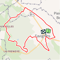
Tour Wandern von 10,2 km verfügbar auf Nordfrankreich, Oise, Savignies. Diese Tour wird von Marie-Claire-mcp vorgeschlagen.

Beschreibung

savignies , Beauvaisis, terre de potiers

Höhenprofil

Ort

Land:
France
Region :
Nordfrankreich
Abteilung/Provinz :
Oise
Kommune :
Savignies
Standort:
Unknown
Gehen Sie:(Dec)
Gehen Sie:(UTM)
425023 ; 5479644 (31U) N.

Kommentare

Bitte melden Sie sich an, um einen Kommentar oder eine Bewertung zu hinterlassen


non


Touren in der Umgebung

Tour Mountainbike Lachapelle-aux-Pots - ACTIVE LOG 003 - Photo
Mountainbike
sebcar

Mountainbike

Medium
(1)
Lachapelle-aux-Pots, Nordfrankreich, Oise, France
19,1 km | 24 km-effort
1h 39min
Ja
Tour Mountainbike Pierrefitte-en-Beauvaisis - Grand tour - Photo
Mountainbike
jjeletufe

Mountainbike

(1)
Pierrefitte-en-Beauvaisis, Nordfrankreich, Oise, France
30 km | 35 km-effort
1h 44min
Ja
Tour Wandern Lachapelle-aux-Pots - Lachapelle-aux-pots - Héricourt - La Frénoye - Armentières - Photo
Wandern
Marie-Claire-mcp

Wandern

Schwierig
Lachapelle-aux-Pots, Nordfrankreich, Oise, France
10,7 km | 13,7 km-effort
3h 6min
Ja
Tour Wandern Lachapelle-aux-Pots - Lachapelle aux pots - Armentières 11 km - Photo
Wandern
Marie-Claire-mcp

Wandern

Schwierig
Lachapelle-aux-Pots, Nordfrankreich, Oise, France
10,6 km | 13,5 km-effort
3h 4min
Ja
Tour Wandern Lachapelle-aux-Pots - Lachapelle aux Pots - Rando santé 1 - Photo
Wandern
marcel.F

Wandern

Medium
Lachapelle-aux-Pots, Nordfrankreich, Oise, France
5,6 km | 6,4 km-effort
1h 24min
Ja
Tour Wandern Lachapelle-aux-Pots - Lachapelle-aux-Pots - autour de la Crapaudière vers 2 - Photo
Wandern
marcel.F

Wandern

Einfach
Lachapelle-aux-Pots, Nordfrankreich, Oise, France
9,9 km | 11,5 km-effort
2h 32min
Ja
Tour Wandern Lachapelle-aux-Pots - Lachapelle-aux-Pots - autour de la Crapaudière - Photo
Wandern
marcel.F

Wandern

Einfach
Lachapelle-aux-Pots, Nordfrankreich, Oise, France
9,4 km | 10,9 km-effort
2h 25min
Ja
Tour Wandern Lachapelle-aux-Pots - Lachapelle aux pots Gare - Photo
Wandern
Marie-Claire-mcp

Wandern

Medium
Lachapelle-aux-Pots, Nordfrankreich, Oise, France
10,6 km | 12,4 km-effort
2h 37min
Ja
Tour Wandern Lachapelle-aux-Pots - Lachapelle aux pots - Photo
Wandern
Marie-Claire-mcp

Wandern

Einfach
Lachapelle-aux-Pots, Nordfrankreich, Oise, France
10,2 km | 12 km-effort
2h 37min
Ja


Schließen
Meine Abonnements