![](/images/other/stat-length.png)
![Tour Wandern Saint-Cergue - YHH082 La Cure - St Cergue - Photo](https://media.geolcdn.com/t/1900/400/ext.pjpeg?maxdim=2&url=https%3A%2F%2Fstatic1.geolcdn.com%2Fsiteimages%2Fupload%2Ffiles%2F1553511878bg_sport_marche.png)
YHH082 La Cure - St Cergue
yveshumbert
Benutzer
![Länge](/images/other/stat-length.png)
Länge
12,8 km
![Maximale Höhe](https://static1.geolcdn.com/siteimages/upload/files/1508320355ic_sort_altitude_max_24dp.png)
Maximale Höhe
1466 m
![Positive Höhendifferenz](https://static1.geolcdn.com/siteimages/upload/files/1508320355ic_sort_den_pos_24dp.png)
Positive Höhendifferenz
415 m
![Km-Effort](/images/other/stat-length.png)
Km-Effort
18,7 km
![Min. Höhe](https://static1.geolcdn.com/siteimages/upload/files/1508320355ic_sort_altitude_min_24dp.png)
Min. Höhe
1046 m
![Negative Höhendifferenz](https://static1.geolcdn.com/siteimages/upload/files/1508320355ic_sort_den_neg_24dp.png)
Negative Höhendifferenz
525 m
![Boucle](https://static1.geolcdn.com/siteimages/upload/files/16400158638029165_repeat_loop_refresh_sync_direction_icon.png)
Boucle
Nein
Erstellungsdatum :
2014-12-10 00:00:00.0
Letzte Änderung :
2014-12-10 00:00:00.0
![Wandern](https://static1.geolcdn.com/sitytour/trail-icons/101.png)
4h00
Schwierigkeit : Unbekannt
![Scannen Sie diesen QR-Code, um die Tour in der SityTrail-Anwendung zu öffnen](https://capi.geolives.com/qq0zvz2zws4bq2lad0pu/sitytour/trails/46659/qr.png?size=200)
Kostenlosegpshiking-Anwendung
Über SityTrail
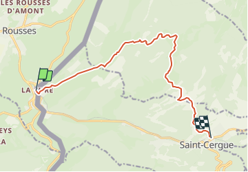
Tour Wandern von 12,8 km verfügbar auf Waadt, District de Nyon, Saint-Cergue. Diese Tour wird von yveshumbert vorgeschlagen.
Beschreibung
Parquer se voiture à St-Cergue dans le parking de l''office du tourisme. Marcher les 5 minutes pour aller à la gare. Prendre le train pour aller à la Cure. On revient à St-Cergue par de jolis petit chemins.
Ort
Land:
Switzerland
Region :
Waadt
Abteilung/Provinz :
District de Nyon
Kommune :
Saint-Cergue
Standort:
Unknown
Gehen Sie:(Dec)
Gehen Sie:(UTM)
275256 ; 5149870 (32T) N.
Kommentare
Touren in der Umgebung
![Tour Fahrrad - Lac de Lamoura et Valserine - Prémanon - Photo](https://media.geolcdn.com/t/375/260/ext.jpg?maxdim=2&url=https%3A%2F%2Fservices.sitytrail.com%2FGeolivesWS%2FDownloadMedia.ashx%3FTrailID%3D317353%26Media%3D16571_5.jpg)
![Fahrrad Fahrrad](https://static1.geolcdn.com/sitytour/trail-icons/200.png)
Lac de Lamoura et Valserine - Prémanon
Fahrrad
Medium
(1)
,
Burgund und Freigrafschaft,
Jura,
France
![](/images/other/stat-length.png)
39 km | 49 km-effort
2h 0min
![](https://static1.geolcdn.com/siteimages/upload/files/16400158638029165_repeat_loop_refresh_sync_direction_icon.png)
Ja
![Tour Wandern - Le Belvédère des Maquisards - Prémanon - Photo](https://media.geolcdn.com/t/375/260/ext.jpg?maxdim=2&url=https%3A%2F%2Fservices.sitytrail.com%2FGeolivesWS%2FDownloadMedia.ashx%3FTrailID%3D191470%26Media%3D15062_5.jpg)
![Wandern Wandern](https://static1.geolcdn.com/sitytour/trail-icons/101.png)
Le Belvédère des Maquisards - Prémanon
Wandern
Medium
(1)
,
Burgund und Freigrafschaft,
Jura,
France
![](/images/other/stat-length.png)
5,4 km | 7,8 km-effort
2h 0min
![](https://static1.geolcdn.com/siteimages/upload/files/16400158638029165_repeat_loop_refresh_sync_direction_icon.png)
Ja
![Tour Wandern - Autour de Prémanon - Photo](https://media.geolcdn.com/t/375/260/ext.jpg?maxdim=2&url=https%3A%2F%2Fservices.sitytrail.com%2FGeolivesWS%2FDownloadMedia.ashx%3FTrailID%3D191468%26Media%3D15060_4.jpg)
![Wandern Wandern](https://static1.geolcdn.com/sitytour/trail-icons/101.png)
Autour de Prémanon
Wandern
Sehr schwierig
(1)
,
Burgund und Freigrafschaft,
Jura,
France
![](/images/other/stat-length.png)
18 km | 27 km-effort
6h 0min
![](https://static1.geolcdn.com/siteimages/upload/files/16400158638029165_repeat_loop_refresh_sync_direction_icon.png)
Ja
![Tour Wandern Les Rousses - Le Noirmont - Les Rousses - Photo](https://media.geolcdn.com/t/375/260/ext.jpg?maxdim=2&url=https%3A%2F%2Fservices.sitytrail.com%2FGeolivesWS%2FDownloadMedia.ashx%3FTrailID%3D191437%26Media%3D15025_5.jpg)
![Wandern Wandern](https://static1.geolcdn.com/sitytour/trail-icons/101.png)
Le Noirmont - Les Rousses
Wandern
Sehr schwierig
(2)
Les Rousses,
Burgund und Freigrafschaft,
Jura,
France
![](/images/other/stat-length.png)
15,1 km | 23 km-effort
6h 0min
![](https://static1.geolcdn.com/siteimages/upload/files/16400158638029165_repeat_loop_refresh_sync_direction_icon.png)
Ja
![Tour Wandern Prémanon - dole1 - Photo](https://media.geolcdn.com/t/375/260/ext.jpg?maxdim=2&url=https%3A%2F%2Fservices.sitytrail.com%2FGeolivesWS%2FDownloadMedia.ashx%3FTrailID%3D136383%26Media%3D20120623131628.jpg)
![Wandern Wandern](https://static1.geolcdn.com/sitytour/trail-icons/101.png)
dole1
Wandern
Sehr leicht
(2)
Prémanon,
Burgund und Freigrafschaft,
Jura,
France
![](/images/other/stat-length.png)
6,6 km | 12,5 km-effort
1h 49min
![](https://static1.geolcdn.com/siteimages/upload/files/16400158638029165_repeat_loop_refresh_sync_direction_icon.png)
Ja
![Tour Zu Fuß - Les Arcets - Photo](https://media.geolcdn.com/t/375/260/dbf9401a-4a63-43b8-9f8e-030f59772016.jpeg&format=jpg&maxdim=2)
![Zu Fuß Zu Fuß](https://static1.geolcdn.com/sitytour/trail-icons/100.png)
Les Arcets
Zu Fuß
Einfach
,
Burgund und Freigrafschaft,
Jura,
France
![](/images/other/stat-length.png)
9 km | 13,6 km-effort
3h 5min
![](https://static1.geolcdn.com/siteimages/upload/files/16400158638029165_repeat_loop_refresh_sync_direction_icon.png)
Ja
![Tour Zu Fuß Gingins - La Dôle - Photo](https://media.geolcdn.com/t/375/260/bf264b50-f9a3-4efb-927b-5cb1cac5e347.jpeg&format=jpg&maxdim=2)
![Zu Fuß Zu Fuß](https://static1.geolcdn.com/sitytour/trail-icons/100.png)
La Dôle
Zu Fuß
Einfach
Gingins,
Waadt,
District de Nyon,
Switzerland
![](/images/other/stat-length.png)
8 km | 15,4 km-effort
3h 30min
![](https://static1.geolcdn.com/siteimages/upload/files/16400158638029165_repeat_loop_refresh_sync_direction_icon.png)
Ja
![Tour Wandern - Prémanon, Mont Fier - Photo](https://media.geolcdn.com/t/375/260/ext.jpg?maxdim=2&url=https%3A%2F%2Fstatic1.geolcdn.com%2Fsiteimages%2Fupload%2Ffiles%2F1553511878bg_sport_marche.png)
![Wandern Wandern](https://static1.geolcdn.com/sitytour/trail-icons/101.png)
Prémanon, Mont Fier
Wandern
Sehr leicht
(1)
,
Burgund und Freigrafschaft,
Jura,
France
![](/images/other/stat-length.png)
10,9 km | 15,8 km-effort
2h 34min
![](https://static1.geolcdn.com/siteimages/upload/files/16400158638029165_repeat_loop_refresh_sync_direction_icon.png)
Nein
![Tour Schneeschuhwandern Les Rousses - Lac des Rousses - Photo](https://media.geolcdn.com/t/375/260/ext.jpg?maxdim=2&url=https%3A%2F%2Fstatic1.geolcdn.com%2Fsiteimages%2Fupload%2Ffiles%2F1524743153raquette.jpg)
![Schneeschuhwandern Schneeschuhwandern](https://static1.geolcdn.com/sitytour/trail-icons/504.png)
Lac des Rousses
Schneeschuhwandern
Medium
(1)
Les Rousses,
Burgund und Freigrafschaft,
Jura,
France
![](/images/other/stat-length.png)
13,8 km | 18,4 km-effort
4h 15min
![](https://static1.geolcdn.com/siteimages/upload/files/16400158638029165_repeat_loop_refresh_sync_direction_icon.png)
Ja