![](/images/other/stat-length.png)
![Tour Wandern Beaufort - Ref de la Laie vers refuge du Presset - Photo](https://media.geolcdn.com/t/1900/400/ext.pjpeg?maxdim=2&url=https%3A%2F%2Fstatic1.geolcdn.com%2Fsiteimages%2Fupload%2Ffiles%2F1553511878bg_sport_marche.png)
Ref de la Laie vers refuge du Presset
stjullie
Benutzer
![Länge](/images/other/stat-length.png)
![Maximale Höhe](https://static1.geolcdn.com/siteimages/upload/files/1508320355ic_sort_altitude_max_24dp.png)
![Positive Höhendifferenz](https://static1.geolcdn.com/siteimages/upload/files/1508320355ic_sort_den_pos_24dp.png)
![Km-Effort](/images/other/stat-length.png)
![Min. Höhe](https://static1.geolcdn.com/siteimages/upload/files/1508320355ic_sort_altitude_min_24dp.png)
![Negative Höhendifferenz](https://static1.geolcdn.com/siteimages/upload/files/1508320355ic_sort_den_neg_24dp.png)
![Boucle](https://static1.geolcdn.com/siteimages/upload/files/16400158638029165_repeat_loop_refresh_sync_direction_icon.png)
![Wandern](https://static1.geolcdn.com/sitytour/trail-icons/101.png)
5h17
Schwierigkeit : Medium
![Scannen Sie diesen QR-Code, um die Tour in der SityTrail-Anwendung zu öffnen](https://capi.geolives.com/qq0zvz2zws4bq2lad0pu/sitytour/trails/466170/qr.png?size=200)
Kostenlosegpshiking-Anwendung
Über SityTrail
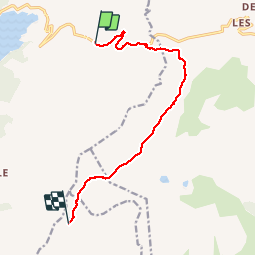
Tour Wandern von 10,6 km verfügbar auf Auvergne-Rhone-Alpen, Savoyen, Beaufort. Diese Tour wird von stjullie vorgeschlagen.
Beschreibung
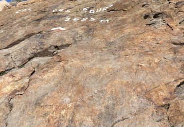
Obligation de prendre la route jusqu'au Cormet de Roselend, mais ça passe très vite. Très belle montée sans difficultés avec le Mont Blanc dans le Dos. Petit pierrier avant le passage du Col du Grand Fond. Au Col : c'est fantastique. Refuge du Presset flambant neuf, gardien et aides gardiens au top ! La vue du refuge est exceptionnelle. Electricité et douche chaude : le grand luxe.
Ort
Kommentare
Touren in der Umgebung
![Tour Wandern Beaufort - Du refuge du Plan de la laie au refuge de la Croix du Bonhomme - Photo](https://media.geolcdn.com/t/375/260/ext.jpg?maxdim=2&url=https%3A%2F%2Fservices.sitytrail.com%2FGeolivesWS%2FDownloadMedia.ashx%3FTrailID%3D605207%26Media%3D510e5eef-7385-455b-8e69-ea984ac16f39.jpg)
![Wandern Wandern](https://static1.geolcdn.com/sitytour/trail-icons/101.png)
Wandern
![](/images/other/stat-length.png)
![](https://static1.geolcdn.com/siteimages/upload/files/16400158638029165_repeat_loop_refresh_sync_direction_icon.png)
![Tour Wandern Bourg-Saint-Maurice - suuntoapp-Hiking-2024-09-10T06-18-18Z - Photo](https://media.geolcdn.com/t/375/260/2ffa221c-2b68-468e-ba02-fb43d145165a.jpg&format=jpg&maxdim=2)
![Wandern Wandern](https://static1.geolcdn.com/sitytour/trail-icons/101.png)
Wandern
![](/images/other/stat-length.png)
![](https://static1.geolcdn.com/siteimages/upload/files/16400158638029165_repeat_loop_refresh_sync_direction_icon.png)
![Tour Wandern La Plagne-Tarentaise - suuntoapp-Hiking-2024-09-09T06-09-09Z - Photo](https://media.geolcdn.com/t/375/260/b6087b8c-1dc3-46a1-846c-8446c87c1444.jpg&format=jpg&maxdim=2)
![Wandern Wandern](https://static1.geolcdn.com/sitytour/trail-icons/101.png)
Wandern
![](/images/other/stat-length.png)
![](https://static1.geolcdn.com/siteimages/upload/files/16400158638029165_repeat_loop_refresh_sync_direction_icon.png)
![Tour Skiwanderen Beaufort - Passage d'Arpire, col Bresson, brèche de Parozan - Photo](https://media.geolcdn.com/t/375/260/cef576dc-81b5-4e18-a375-2d133cd76090.jpg&format=jpg&maxdim=2)
![Skiwanderen Skiwanderen](https://static1.geolcdn.com/sitytour/trail-icons/503.png)
Skiwanderen
![](/images/other/stat-length.png)
![](https://static1.geolcdn.com/siteimages/upload/files/16400158638029165_repeat_loop_refresh_sync_direction_icon.png)
![Tour Wandern Beaufort - lac de Presset et passeur de la Mintaz (belvédère de la Pierra Menta) - Photo](https://media.geolcdn.com/t/375/260/0e1a7432-483a-440c-958e-0a3e3d697f7b.jpg&format=jpg&maxdim=2)
![Wandern Wandern](https://static1.geolcdn.com/sitytour/trail-icons/101.png)
Wandern
![](/images/other/stat-length.png)
![](https://static1.geolcdn.com/siteimages/upload/files/16400158638029165_repeat_loop_refresh_sync_direction_icon.png)
![Tour Wandern La Plagne-Tarentaise - Du refuge de Presset au refuge de la Coire - Photo](https://media.geolcdn.com/t/375/260/ext.jpg?maxdim=2&url=https%3A%2F%2Fservices.sitytrail.com%2FGeolivesWS%2FDownloadMedia.ashx%3FTrailID%3D612521%26Media%3D65c78503-17c1-4137-a504-eeeac73dd9ba.jpg)
![Wandern Wandern](https://static1.geolcdn.com/sitytour/trail-icons/101.png)
Wandern
![](/images/other/stat-length.png)
![](https://static1.geolcdn.com/siteimages/upload/files/16400158638029165_repeat_loop_refresh_sync_direction_icon.png)
![Tour Wandern Beaufort - Rocher du Vent 7,8 km -570 m + - Photo](https://media.geolcdn.com/t/375/260/9d77b27d-0052-43ba-aa7f-4b36e35a1567.jpg&format=jpg&maxdim=2)
![Wandern Wandern](https://static1.geolcdn.com/sitytour/trail-icons/101.png)
Wandern
![](/images/other/stat-length.png)
![](https://static1.geolcdn.com/siteimages/upload/files/16400158638029165_repeat_loop_refresh_sync_direction_icon.png)
![Tour Wandern Beaufort - Lac d’Amour - col du Coin 10 km -680 m dénivelé + - Photo](https://media.geolcdn.com/t/375/260/3b47f1f6-ac20-42ea-91ad-660067538617.jpg&format=jpg&maxdim=2)
![Wandern Wandern](https://static1.geolcdn.com/sitytour/trail-icons/101.png)
Wandern
![](/images/other/stat-length.png)
![](https://static1.geolcdn.com/siteimages/upload/files/16400158638029165_repeat_loop_refresh_sync_direction_icon.png)
![Tour Wandern Bourg-Saint-Maurice - Les chapieux-col des four - Photo](https://media.geolcdn.com/t/375/260/95a94c92-2d9f-4b93-87c7-1335119f6081.jpeg&format=jpg&maxdim=2)
![Wandern Wandern](https://static1.geolcdn.com/sitytour/trail-icons/101.png)
Wandern
![](/images/other/stat-length.png)
![](https://static1.geolcdn.com/siteimages/upload/files/16400158638029165_repeat_loop_refresh_sync_direction_icon.png)