![](/images/other/stat-length.png)
![Tour Wandern Saint-Dalmas-le-Selvage - FORT CARRA - Photo](https://media.geolcdn.com/t/1900/400/ext.pjpeg?maxdim=2&url=https%3A%2F%2Fstatic1.geolcdn.com%2Fsiteimages%2Fupload%2Ffiles%2F1553511878bg_sport_marche.png)
FORT CARRA
fredopaca
Benutzer
![Länge](/images/other/stat-length.png)
![Maximale Höhe](https://static1.geolcdn.com/siteimages/upload/files/1508320355ic_sort_altitude_max_24dp.png)
![Positive Höhendifferenz](https://static1.geolcdn.com/siteimages/upload/files/1508320355ic_sort_den_pos_24dp.png)
![Km-Effort](/images/other/stat-length.png)
![Min. Höhe](https://static1.geolcdn.com/siteimages/upload/files/1508320355ic_sort_altitude_min_24dp.png)
![Negative Höhendifferenz](https://static1.geolcdn.com/siteimages/upload/files/1508320355ic_sort_den_neg_24dp.png)
![Boucle](https://static1.geolcdn.com/siteimages/upload/files/16400158638029165_repeat_loop_refresh_sync_direction_icon.png)
![Wandern](https://static1.geolcdn.com/sitytour/trail-icons/101.png)
5h09
Schwierigkeit : Schwierig
![Scannen Sie diesen QR-Code, um die Tour in der SityTrail-Anwendung zu öffnen](https://capi.geolives.com/qq0zvz2zws4bq2lad0pu/sitytour/trails/458043/qr.png?size=200)
Kostenlosegpshiking-Anwendung
Über SityTrail
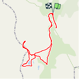
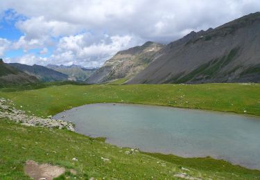
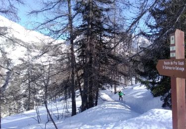
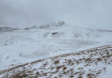
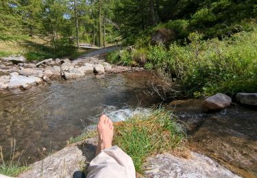
Tour Wandern von 12,5 km verfügbar auf Provence-Alpes-Côte d'Azur, Seealpen, Saint-Dalmas-le-Selvage. Diese Tour wird von fredopaca vorgeschlagen.
Beschreibung
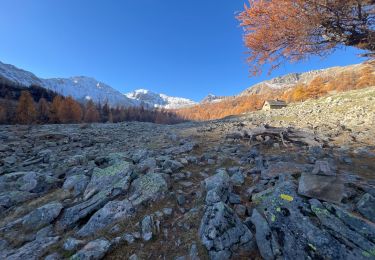
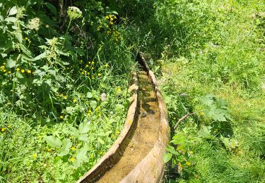
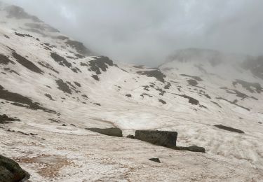
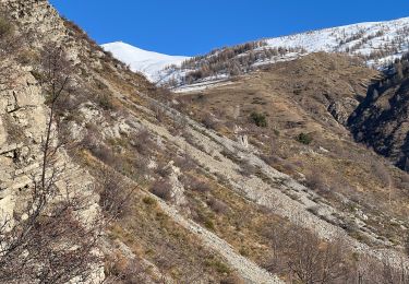
de st dalmas de selvage prévoir voiture 4x4 pour aller au DÉPART BALISE 73 remonter le vallon de Gialorgues prendre direction le refuge prendre sur la droite au niveau de sagne chemin a coter du ruisseau cairn sur la droite et évoluer sur pente rocheuses et ensuite herbeuses bien raide jusqu’au la brèche du fort carra retour soit par le même chemin ou une boucle vers lacs de gialorgues et direction le refuge retour sur le point de départ balise 73 une jolie cascade à voir au bout de cette balise sur sentier carrossable jolie point vue
Ort
Kommentare
Touren in der Umgebung
![Tour Zu Fuß Saint-Dalmas-le-Selvage - Col de Gialorgues - Photo](https://media.geolcdn.com/t/375/260/00cae92e-e0d3-4da8-9c98-398ca7383338.jpeg&format=jpg&maxdim=2)
![Zu Fuß Zu Fuß](https://static1.geolcdn.com/sitytour/trail-icons/100.png)
Zu Fuß
![](/images/other/stat-length.png)
![](https://static1.geolcdn.com/siteimages/upload/files/16400158638029165_repeat_loop_refresh_sync_direction_icon.png)
![Tour Skiwanderen Saint-Dalmas-le-Selvage - tentative de la crête de carpasse, et la croix de carlet - Photo](https://media.geolcdn.com/t/375/260/1fd4df26-1c9e-4eb6-8b35-62f8038fd665.jpg&format=jpg&maxdim=2)
![Skiwanderen Skiwanderen](https://static1.geolcdn.com/sitytour/trail-icons/503.png)
Skiwanderen
![](/images/other/stat-length.png)
![](https://static1.geolcdn.com/siteimages/upload/files/16400158638029165_repeat_loop_refresh_sync_direction_icon.png)
![Tour Schneeschuhwandern Saint-Dalmas-le-Selvage - Col de l’Escuzier - Photo](https://media.geolcdn.com/t/375/260/a7996d3e-274b-4a79-9e99-e849df4c64a6.jpg&format=jpg&maxdim=2)
![Schneeschuhwandern Schneeschuhwandern](https://static1.geolcdn.com/sitytour/trail-icons/504.png)
Schneeschuhwandern
![](/images/other/stat-length.png)
![](https://static1.geolcdn.com/siteimages/upload/files/16400158638029165_repeat_loop_refresh_sync_direction_icon.png)
![Tour Wandern Saint-Dalmas-le-Selvage - Tête de la Clape - Photo](https://media.geolcdn.com/t/375/260/0e3fdea2-c0e9-46f3-8d17-68d5856dfe0e.jpg&format=jpg&maxdim=2)
![Wandern Wandern](https://static1.geolcdn.com/sitytour/trail-icons/101.png)
Wandern
![](/images/other/stat-length.png)
![](https://static1.geolcdn.com/siteimages/upload/files/16400158638029165_repeat_loop_refresh_sync_direction_icon.png)
![Tour Wandern Saint-Dalmas-le-Selvage - Crête de Pre Gaze et Abri de Giant, de Saint Dalmas de Selvage - Photo](https://media.geolcdn.com/t/375/260/ee9e49c5-2367-43ef-addb-6f9c220a2acc.jpg&format=jpg&maxdim=2)
![Wandern Wandern](https://static1.geolcdn.com/sitytour/trail-icons/101.png)
Wandern
![](/images/other/stat-length.png)
![](https://static1.geolcdn.com/siteimages/upload/files/16400158638029165_repeat_loop_refresh_sync_direction_icon.png)
![Tour Wandern Saint-Dalmas-le-Selvage - Col de la Braïssa - Photo](https://media.geolcdn.com/t/375/260/170d0a5a-0a27-455b-95e1-d5466fcdcb91.jpg&format=jpg&maxdim=2)
![Wandern Wandern](https://static1.geolcdn.com/sitytour/trail-icons/101.png)
Wandern
![](/images/other/stat-length.png)
![](https://static1.geolcdn.com/siteimages/upload/files/16400158638029165_repeat_loop_refresh_sync_direction_icon.png)
![Tour Schneeschuhwandern Saint-Dalmas-le-Selvage - Col de la Moutière - Photo](https://media.geolcdn.com/t/375/260/6193d5c1-3fac-4078-bf82-dfec6429945b.jpg&format=jpg&maxdim=2)
![Schneeschuhwandern Schneeschuhwandern](https://static1.geolcdn.com/sitytour/trail-icons/504.png)
Schneeschuhwandern
![](/images/other/stat-length.png)
![](https://static1.geolcdn.com/siteimages/upload/files/16400158638029165_repeat_loop_refresh_sync_direction_icon.png)
![Tour Schneeschuhwandern Saint-Dalmas-le-Selvage - Tête de Vinaigre - Photo](https://media.geolcdn.com/t/375/260/988ed70f-3fed-482a-9d6b-d2e36aaeab12.jpg&format=jpg&maxdim=2)
![Schneeschuhwandern Schneeschuhwandern](https://static1.geolcdn.com/sitytour/trail-icons/504.png)
Schneeschuhwandern
![](/images/other/stat-length.png)
![](https://static1.geolcdn.com/siteimages/upload/files/16400158638029165_repeat_loop_refresh_sync_direction_icon.png)
![Tour Wandern Saint-Dalmas-le-Selvage - Sestrieres - col de Braïssa - Photo](https://media.geolcdn.com/t/375/260/dd0ea3c4-8af4-4c42-9f9e-1a7bed2e435d.jpg&format=jpg&maxdim=2)
![Wandern Wandern](https://static1.geolcdn.com/sitytour/trail-icons/101.png)
Wandern
![](/images/other/stat-length.png)
![](https://static1.geolcdn.com/siteimages/upload/files/16400158638029165_repeat_loop_refresh_sync_direction_icon.png)