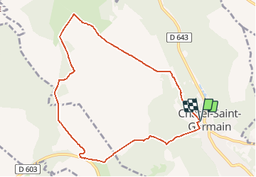
![](/images/other/stat-length.png)
![Tour Wandern Sankt German - Promenade des orchidées - Photo](https://media.geolcdn.com/t/1900/400/ext.pjpeg?maxdim=2&url=https%3A%2F%2Fstatic1.geolcdn.com%2Fsiteimages%2Fupload%2Ffiles%2F1553511878bg_sport_marche.png)
Promenade des orchidées
ticaillou
Benutzer
![Länge](/images/other/stat-length.png)
![Maximale Höhe](https://static1.geolcdn.com/siteimages/upload/files/1508320355ic_sort_altitude_max_24dp.png)
![Positive Höhendifferenz](https://static1.geolcdn.com/siteimages/upload/files/1508320355ic_sort_den_pos_24dp.png)
![Km-Effort](/images/other/stat-length.png)
![Min. Höhe](https://static1.geolcdn.com/siteimages/upload/files/1508320355ic_sort_altitude_min_24dp.png)
![Negative Höhendifferenz](https://static1.geolcdn.com/siteimages/upload/files/1508320355ic_sort_den_neg_24dp.png)
![Boucle](https://static1.geolcdn.com/siteimages/upload/files/16400158638029165_repeat_loop_refresh_sync_direction_icon.png)
![Kennzeichnung](https://services.sitytrail.com/GeolivesWS/DownloadMedia.ashx?TrailID=457270&Media=balise.png)
![Wandern](https://static1.geolcdn.com/sitytour/trail-icons/101.png)
2h26
Schwierigkeit : Sehr leicht
![Scannen Sie diesen QR-Code, um die Tour in der SityTrail-Anwendung zu öffnen](https://capi.geolives.com/qq0zvz2zws4bq2lad0pu/sitytour/trails/457270/qr.png?size=200)
Kostenlosegpshiking-Anwendung
Über SityTrail
Tour Wandern von 8,8 km verfügbar auf Großer Osten, Mosel, Sankt German. Diese Tour wird von ticaillou vorgeschlagen.
Beschreibung
Au départ du square de Tagnon en contrebas de l'entrée du parking prendre le sentier du Prieuré et monter au Mont-Saint-Germain. Traverser le site, la pelouse calcaire et prendre le route de guerre à gauche. Au parking prendre la route de Vernéville, dépasser la ferme de Leipzig. Avant la ferme de la Folie prendre à gauche le chemin des Bannaires. Pénétrer dans le bois, prendre à gauche en direction de la ferme Saint Hubert. Le monument de la bataille de 1870 se situe au débouché d'un chemin creux, la taie au renard, montant des Génivaux vers le plateau, voie utilisée par les Prussiens, par l'armée américaine en novembre 1944 et peut-être déjà par les romains. Après la ferme Saint-Hubert se diriger vers la ferme de Moscou, longer le Fort Jeanne d'Arc par la gauche et continuer tout droit en passant au Hêtre des batailles. Couper la route de guerre et descendre vers Châtel par le chemin de Gravelotte. A la rue de Bonne Fontaine prendre à gauche pour retourner au square de Tagnon.
Ort
Kommentare
Touren in der Umgebung
![Tour Wandern Papolsheim - Saint Quentin - Photo](https://media.geolcdn.com/t/375/260/ext.jpg?maxdim=2&url=https%3A%2F%2Fservices.sitytrail.com%2FGeolivesWS%2FDownloadMedia.ashx%3FTrailID%3D159776%26Media%3D20121024120133.jpg)
![Wandern Wandern](https://static1.geolcdn.com/sitytour/trail-icons/101.png)
Wandern
![](/images/other/stat-length.png)
![](https://static1.geolcdn.com/siteimages/upload/files/16400158638029165_repeat_loop_refresh_sync_direction_icon.png)
![Tour Wandern Sankt German - Châtel-Saint-Germain - Photo](https://media.geolcdn.com/t/375/260/ext.jpg?maxdim=2&url=https%3A%2F%2Fservices.sitytrail.com%2FGeolivesWS%2FDownloadMedia.ashx%3FTrailID%3D150891%26Media%3D20120830125222.jpg)
![Wandern Wandern](https://static1.geolcdn.com/sitytour/trail-icons/101.png)
Wandern
![](/images/other/stat-length.png)
![](https://static1.geolcdn.com/siteimages/upload/files/16400158638029165_repeat_loop_refresh_sync_direction_icon.png)
![Tour Wandern Papolsheim - Autour du fort de Plappeville. - Photo](https://media.geolcdn.com/t/375/260/ext.jpg?maxdim=2&url=https%3A%2F%2Fservices.sitytrail.com%2FGeolivesWS%2FDownloadMedia.ashx%3FTrailID%3D147559%26Media%3D20120816102740.jpg)
![Wandern Wandern](https://static1.geolcdn.com/sitytour/trail-icons/101.png)
Wandern
![](/images/other/stat-length.png)
![](https://static1.geolcdn.com/siteimages/upload/files/16400158638029165_repeat_loop_refresh_sync_direction_icon.png)
![Tour Zu Fuß Wals - Circuit de la Vallée de la Mance - Photo](https://media.geolcdn.com/t/375/260/981790cb-52ff-420b-b1f6-a906426f0c54.jpeg&format=jpg&maxdim=2)
![Zu Fuß Zu Fuß](https://static1.geolcdn.com/sitytour/trail-icons/100.png)
Zu Fuß
![](/images/other/stat-length.png)
![](https://static1.geolcdn.com/siteimages/upload/files/16400158638029165_repeat_loop_refresh_sync_direction_icon.png)
![Tour Zu Fuß Lessingen - Circuit de Plappeville - Photo](https://media.geolcdn.com/t/375/260/7273a269-0c57-4318-8c49-dbed329cb79a.jpeg&format=jpg&maxdim=2)
![Zu Fuß Zu Fuß](https://static1.geolcdn.com/sitytour/trail-icons/100.png)
Zu Fuß
![](/images/other/stat-length.png)
![](https://static1.geolcdn.com/siteimages/upload/files/16400158638029165_repeat_loop_refresh_sync_direction_icon.png)
![Tour Zu Fuß Scy-Chazelles - Circuit Robert Schuman - Photo](https://media.geolcdn.com/t/375/260/7afac14e-8e32-42d2-8dfe-26d9e6a8df51.jpeg&format=jpg&maxdim=2)
![Zu Fuß Zu Fuß](https://static1.geolcdn.com/sitytour/trail-icons/100.png)
Zu Fuß
![](/images/other/stat-length.png)
![](https://static1.geolcdn.com/siteimages/upload/files/16400158638029165_repeat_loop_refresh_sync_direction_icon.png)
![Tour Zu Fuß Scy-Chazelles - Circuit du Tour du Mont St Quentin - Photo](https://media.geolcdn.com/t/375/260/0227a6bb-ecc7-41f2-b92a-b603e3858c5b.jpeg&format=jpg&maxdim=2)
![Zu Fuß Zu Fuß](https://static1.geolcdn.com/sitytour/trail-icons/100.png)
Zu Fuß
![](/images/other/stat-length.png)
![](https://static1.geolcdn.com/siteimages/upload/files/16400158638029165_repeat_loop_refresh_sync_direction_icon.png)
![Tour Wandern Saulny - plesnois - Photo](https://media.geolcdn.com/t/375/260/30dd64af-04ad-4ba2-adb2-9542b50b478b.jpg&format=jpg&maxdim=2)
![Wandern Wandern](https://static1.geolcdn.com/sitytour/trail-icons/101.png)
![Tour Wandern Saulny - Saulny 8 mai 2013 14 km - Photo](https://media.geolcdn.com/t/375/260/ext.jpg?maxdim=2&url=https%3A%2F%2Fstatic1.geolcdn.com%2Fsiteimages%2Fupload%2Ffiles%2F1553511878bg_sport_marche.png)
![Wandern Wandern](https://static1.geolcdn.com/sitytour/trail-icons/101.png)
Wandern
![](/images/other/stat-length.png)
![](https://static1.geolcdn.com/siteimages/upload/files/16400158638029165_repeat_loop_refresh_sync_direction_icon.png)