![](/images/other/stat-length.png)
![Tour Fahrrad Weismes - Waimes-Montenau-Honsfeld - Photo](https://media.geolcdn.com/t/1900/400/ext.pjpeg?maxdim=2&url=https%3A%2F%2Fstatic1.geolcdn.com%2Fsiteimages%2Fupload%2Ffiles%2F1524743154velo.jpg)
Waimes-Montenau-Honsfeld
leeho
Benutzer
![Länge](/images/other/stat-length.png)
Länge
39 km
![Maximale Höhe](https://static1.geolcdn.com/siteimages/upload/files/1508320355ic_sort_altitude_max_24dp.png)
Maximale Höhe
633 m
![Positive Höhendifferenz](https://static1.geolcdn.com/siteimages/upload/files/1508320355ic_sort_den_pos_24dp.png)
Positive Höhendifferenz
524 m
![Km-Effort](/images/other/stat-length.png)
Km-Effort
46 km
![Min. Höhe](https://static1.geolcdn.com/siteimages/upload/files/1508320355ic_sort_altitude_min_24dp.png)
Min. Höhe
420 m
![Negative Höhendifferenz](https://static1.geolcdn.com/siteimages/upload/files/1508320355ic_sort_den_neg_24dp.png)
Negative Höhendifferenz
520 m
![Boucle](https://static1.geolcdn.com/siteimages/upload/files/16400158638029165_repeat_loop_refresh_sync_direction_icon.png)
Boucle
Ja
Erstellungsdatum :
2015-08-01 00:00:00.0
Letzte Änderung :
2015-08-01 00:00:00.0
![Fahrrad](https://static1.geolcdn.com/sitytour/trail-icons/200.png)
2h39
Schwierigkeit : Einfach
![Scannen Sie diesen QR-Code, um die Tour in der SityTrail-Anwendung zu öffnen](https://capi.geolives.com/qq0zvz2zws4bq2lad0pu/sitytour/trails/452586/qr.png?size=200)
Kostenlosegpshiking-Anwendung
Über SityTrail
Tour Fahrrad von 39 km verfügbar auf Wallonien, Lüttich, Weismes. Diese Tour wird von leeho vorgeschlagen.
Beschreibung
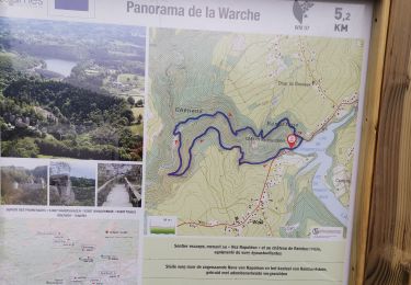
D'après la carte EuroVelo "Hautes Fagnes-Eiffel". Circuit au départ de l'ancienne gare de Waimes, empruntant le Ravel de la Vennbahn et routes secondaires. Retour par le Ravel de L45.
Ort
Land:
Belgium
Region :
Wallonien
Abteilung/Provinz :
Lüttich
Kommune :
Weismes
Standort:
Waimes
Gehen Sie:(Dec)
Gehen Sie:(UTM)
295369 ; 5588166 (32U) N.
Kommentare
Touren in der Umgebung
![Tour Wandern Weismes - 2023-11-10_22h16m17_t119964214_sur les versants de la warchenne w10.gpx.xml - Photo](https://media.geolcdn.com/t/375/260/ca458986-945b-4d88-aa31-13c1465e60e5.jpg&format=jpg&maxdim=2)
![Wandern Wandern](https://static1.geolcdn.com/sitytour/trail-icons/101.png)
2023-11-10_22h16m17_t119964214_sur les versants de la warchenne w10.gpx.xml
Wandern
Medium
(2)
Weismes,
Wallonien,
Lüttich,
Belgium
![](/images/other/stat-length.png)
6,8 km | 8,6 km-effort
1h 57min
![](https://static1.geolcdn.com/siteimages/upload/files/16400158638029165_repeat_loop_refresh_sync_direction_icon.png)
Ja
![Tour Wandern Malmedy - ligneuville - ondeval aller retour - Photo](https://media.geolcdn.com/t/375/260/5d217ee2-30bd-4bc8-82e6-a4da860aa974.jpg&format=jpg&maxdim=2)
![Wandern Wandern](https://static1.geolcdn.com/sitytour/trail-icons/101.png)
ligneuville - ondeval aller retour
Wandern
Einfach
(1)
Malmedy,
Wallonien,
Lüttich,
Belgium
![](/images/other/stat-length.png)
14,4 km | 18,3 km-effort
4h 2min
![](https://static1.geolcdn.com/siteimages/upload/files/16400158638029165_repeat_loop_refresh_sync_direction_icon.png)
Ja
![Tour Wandern Weismes - Waimes 21 km - Photo](https://media.geolcdn.com/t/375/260/ae7b64e4-00bf-4852-8640-e3d490be341c.jpg&format=jpg&maxdim=2)
![Wandern Wandern](https://static1.geolcdn.com/sitytour/trail-icons/101.png)
Waimes 21 km
Wandern
Einfach
(1)
Weismes,
Wallonien,
Lüttich,
Belgium
![](/images/other/stat-length.png)
21 km | 27 km-effort
6h 15min
![](https://static1.geolcdn.com/siteimages/upload/files/16400158638029165_repeat_loop_refresh_sync_direction_icon.png)
Nein
![Tour Wandern Weismes - autour d outrewarche - Photo](https://media.geolcdn.com/t/375/260/24e94693-f32d-413a-bd88-27a7125a5718.jpg&format=jpg&maxdim=2)
![Wandern Wandern](https://static1.geolcdn.com/sitytour/trail-icons/101.png)
autour d outrewarche
Wandern
Sehr leicht
(1)
Weismes,
Wallonien,
Lüttich,
Belgium
![](/images/other/stat-length.png)
7,5 km | 9 km-effort
1h 55min
![](https://static1.geolcdn.com/siteimages/upload/files/16400158638029165_repeat_loop_refresh_sync_direction_icon.png)
Ja
![Tour Wandern Weismes - ROBERTVILLE ... par le Château de REINHARDSTEIN. - Photo](https://media.geolcdn.com/t/375/260/97f54fe4-d67d-4cf5-8933-573ab6ce439e.jpg&format=jpg&maxdim=2)
![Wandern Wandern](https://static1.geolcdn.com/sitytour/trail-icons/101.png)
ROBERTVILLE ... par le Château de REINHARDSTEIN.
Wandern
Medium
(4)
Weismes,
Wallonien,
Lüttich,
Belgium
![](/images/other/stat-length.png)
5,6 km | 7,5 km-effort
1h 16min
![](https://static1.geolcdn.com/siteimages/upload/files/16400158638029165_repeat_loop_refresh_sync_direction_icon.png)
Ja
![Tour Rollerblading Malmedy - Vallée de l'Amblève - Photo](https://media.geolcdn.com/t/375/260/ext.jpg?maxdim=2&url=https%3A%2F%2Fservices.sitytrail.com%2FGeolivesWS%2FDownloadMedia.ashx%3FTrailID%3D767158%26Media%3Dfix__20170605123453.jpg)
![Rollerblading Rollerblading](https://static1.geolcdn.com/sitytour/trail-icons/901.png)
Vallée de l'Amblève
Rollerblading
Einfach
(1)
Malmedy,
Wallonien,
Lüttich,
Belgium
![](/images/other/stat-length.png)
6,4 km | 8,1 km-effort
1h 20min
![](https://static1.geolcdn.com/siteimages/upload/files/16400158638029165_repeat_loop_refresh_sync_direction_icon.png)
Ja
![Tour Wandern Weismes - Robertville. Reinhardstein - Photo](https://media.geolcdn.com/t/375/260/ext.jpg?maxdim=2&url=https%3A%2F%2Fservices.sitytrail.com%2FGeolivesWS%2FDownloadMedia.ashx%3FTrailID%3D94288%26Media%3D20111112151951.jpg)
![Wandern Wandern](https://static1.geolcdn.com/sitytour/trail-icons/101.png)
Robertville. Reinhardstein
Wandern
Medium
(1)
Weismes,
Wallonien,
Lüttich,
Belgium
![](/images/other/stat-length.png)
5,5 km | 7,5 km-effort
Unbekannt
![](https://static1.geolcdn.com/siteimages/upload/files/16400158638029165_repeat_loop_refresh_sync_direction_icon.png)
Ja
![Tour Wandern Amel - La rivière d'or (9km) - Photo](https://media.geolcdn.com/t/375/260/eac006de-c0aa-46b2-933f-e559c8a45d2b.jpg&format=jpg&maxdim=2)
![Wandern Wandern](https://static1.geolcdn.com/sitytour/trail-icons/101.png)
La rivière d'or (9km)
Wandern
Medium
(1)
Amel,
Wallonien,
Lüttich,
Belgium
![](/images/other/stat-length.png)
9 km | 11,9 km-effort
2h 42min
![](https://static1.geolcdn.com/siteimages/upload/files/16400158638029165_repeat_loop_refresh_sync_direction_icon.png)
Ja
![Tour Wandern Weismes - 20240429 - Robertville 7.4 Km - Photo](https://media.geolcdn.com/t/375/260/814945c7-2a01-435d-8d51-d5b6fa569bbb.jpeg&format=jpg&maxdim=2)
![Wandern Wandern](https://static1.geolcdn.com/sitytour/trail-icons/101.png)
20240429 - Robertville 7.4 Km
Wandern
Medium
Weismes,
Wallonien,
Lüttich,
Belgium
![](/images/other/stat-length.png)
7,4 km | 8,9 km-effort
2h 16min
![](https://static1.geolcdn.com/siteimages/upload/files/16400158638029165_repeat_loop_refresh_sync_direction_icon.png)
Ja