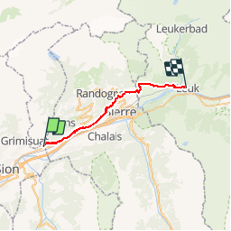
![](/images/other/stat-length.png)
![Tour Wandern Saint-Léonard - Chemin du Vignoble - Photo](https://media.geolcdn.com/t/1900/400/ext.pjpeg?maxdim=2&url=https%3A%2F%2Fservices.sitytrail.com%2FGeolivesWS%2FDownloadMedia.ashx%3FTrailID%3D44672%26Media%3Dimage0.jpg)
Chemin du Vignoble
Maison du Tourisme Crans-Montana
Randonnées de la Maison du tourisme de Crans-Montana GUIDE+
![Länge](/images/other/stat-length.png)
![Maximale Höhe](https://static1.geolcdn.com/siteimages/upload/files/1508320355ic_sort_altitude_max_24dp.png)
![Positive Höhendifferenz](https://static1.geolcdn.com/siteimages/upload/files/1508320355ic_sort_den_pos_24dp.png)
![Km-Effort](/images/other/stat-length.png)
![Min. Höhe](https://static1.geolcdn.com/siteimages/upload/files/1508320355ic_sort_altitude_min_24dp.png)
![Negative Höhendifferenz](https://static1.geolcdn.com/siteimages/upload/files/1508320355ic_sort_den_neg_24dp.png)
![Boucle](https://static1.geolcdn.com/siteimages/upload/files/16400158638029165_repeat_loop_refresh_sync_direction_icon.png)
![Wandern](https://static1.geolcdn.com/sitytour/trail-icons/101.png)
9h00
Schwierigkeit : Unbekannt
![Scannen Sie diesen QR-Code, um die Tour in der SityTrail-Anwendung zu öffnen](https://capi.geolives.com/qq0zvz2zws4bq2lad0pu/sitytour/trails/44672/qr.png?size=200)
Kostenlosegpshiking-Anwendung
Über SityTrail
Tour Wandern von 25 km verfügbar auf Wallis, Siders, Saint-Léonard. Diese Tour wird von Maison du Tourisme Crans-Montana vorgeschlagen.
Beschreibung
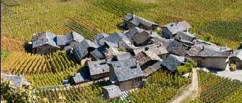
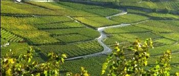
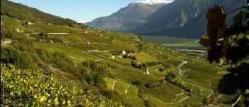
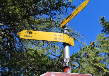
Le chemin du vignoble, c’est environ 25 km répartis entre Saint Léonard et la gare de Loèche-Susten que tout au long du parcours vous pourrez situer en dessous des paraboles de la station terrienne de communication satellite que vous apercevez sur les hauts de Loèche. Ce tracé évoluant entre 500 et 800 m d’altitude est particulièrement adapté à une découverte en plusieurs étapes. En effet sur son tracé, vous croiserez des lignes de transport publics. Le moment idéal dans l’année pour découvrir le vignoble, c’est évidemment les mois d’août septembre alors que les raisins arrivent à maturité sur les ceps vigoureux des coteaux de Flanthey, Corin, Venthône, Salquenen et Varone. Ces parchets de vignes sont travaillés par des vignerons minutieux qui font que la terre, l’eau, l’air et le soleil de notre région se retrouvent sur les meilleures tables, jusqu’au confins du continent et même d’outre mer.
POIs
Ort
Kommentare
Touren in der Umgebung
![Tour Wandern Crans-Montana - Chemin du Vignoble - Itinéraire dégustation - Photo](https://media.geolcdn.com/t/375/260/ext.jpg?maxdim=2&url=https%3A%2F%2Fservices.sitytrail.com%2FGeolivesWS%2FDownloadMedia.ashx%3FTrailID%3D46260%26Media%3Dimage6.jpg)
![Wandern Wandern](https://static1.geolcdn.com/sitytour/trail-icons/101.png)
Wandern
![](/images/other/stat-length.png)
![](https://static1.geolcdn.com/siteimages/upload/files/16400158638029165_repeat_loop_refresh_sync_direction_icon.png)
![Tour Wandern Icogne - Bisse du Sillonin - Photo](https://media.geolcdn.com/t/375/260/ext.jpg?maxdim=2&url=https%3A%2F%2Fservices.sitytrail.com%2FGeolivesWS%2FDownloadMedia.ashx%3FTrailID%3D44661%26Media%3Dimage10.jpg)
![Wandern Wandern](https://static1.geolcdn.com/sitytour/trail-icons/101.png)
Wandern
![](/images/other/stat-length.png)
![](https://static1.geolcdn.com/siteimages/upload/files/16400158638029165_repeat_loop_refresh_sync_direction_icon.png)
![Tour Wandern Savièse - Mayen de la Zour-Prabé - Photo](https://media.geolcdn.com/t/375/260/ext.jpg?maxdim=2&url=https%3A%2F%2Fstatic1.geolcdn.com%2Fsiteimages%2Fupload%2Ffiles%2F1553511878bg_sport_marche.png)
![Wandern Wandern](https://static1.geolcdn.com/sitytour/trail-icons/101.png)
Wandern
![](/images/other/stat-length.png)
![](https://static1.geolcdn.com/siteimages/upload/files/16400158638029165_repeat_loop_refresh_sync_direction_icon.png)
![Tour Wandern Ayent - Au pied du Wildhorn - Photo](https://media.geolcdn.com/t/375/260/ext.jpg?maxdim=2&url=https%3A%2F%2Fstatic1.geolcdn.com%2Fsiteimages%2Fupload%2Ffiles%2F1553511878bg_sport_marche.png)
![Wandern Wandern](https://static1.geolcdn.com/sitytour/trail-icons/101.png)
Wandern
![](/images/other/stat-length.png)
![](https://static1.geolcdn.com/siteimages/upload/files/16400158638029165_repeat_loop_refresh_sync_direction_icon.png)
![Tour Nordic Walking Arbaz - Grimisuat - Photo](https://media.geolcdn.com/t/375/260/7db261da-47d1-45af-86a8-5f533a77d10f.jpg&format=jpg&maxdim=2)
![Nordic Walking Nordic Walking](https://static1.geolcdn.com/sitytour/trail-icons/102.png)
Nordic Walking
![](/images/other/stat-length.png)
![](https://static1.geolcdn.com/siteimages/upload/files/16400158638029165_repeat_loop_refresh_sync_direction_icon.png)
![Tour Nordic Walking Ayent - 07.08.20 Tour des Alpages - Photo](https://media.geolcdn.com/t/375/260/847ec8c8-ca52-45ee-88b9-2d42ecd58e52.jpg&format=jpg&maxdim=2)
![Nordic Walking Nordic Walking](https://static1.geolcdn.com/sitytour/trail-icons/102.png)
Nordic Walking
![](/images/other/stat-length.png)
![](https://static1.geolcdn.com/siteimages/upload/files/16400158638029165_repeat_loop_refresh_sync_direction_icon.png)
![Tour Nordic Walking Arbaz - 27.07.20 Pas de Maimbré - Photo](https://media.geolcdn.com/t/375/260/b8e2c4c6-f220-4a39-9235-6deb05a62b05.jpg&format=jpg&maxdim=2)
![Nordic Walking Nordic Walking](https://static1.geolcdn.com/sitytour/trail-icons/102.png)
Nordic Walking
![](/images/other/stat-length.png)
![](https://static1.geolcdn.com/siteimages/upload/files/16400158638029165_repeat_loop_refresh_sync_direction_icon.png)
![Tour Nordic Walking Arbaz - 23.07.20 Anzère - Photo](https://media.geolcdn.com/t/375/260/6936dbcc-15e7-4a23-9260-f5f09bf86c64.jpg&format=jpg&maxdim=2)
![Nordic Walking Nordic Walking](https://static1.geolcdn.com/sitytour/trail-icons/102.png)
Nordic Walking
![](/images/other/stat-length.png)
![](https://static1.geolcdn.com/siteimages/upload/files/16400158638029165_repeat_loop_refresh_sync_direction_icon.png)